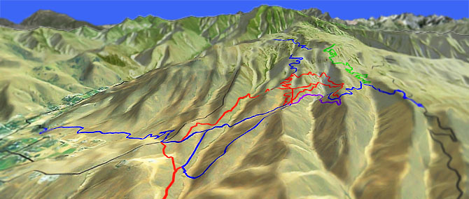
Sage Hills Tr1570
Twitter Search
#SageHillsTrail

Overall: 4
Aerobic: 4
Technical: 4
Steepness: 5
Flow: 5
Singletrack: 100%
West of Wenatchee Washington, Sage Hills is a collection of local trails on BLM and PUD land.
Type
Loop
Length
Avg: 6.5mi
Ascent
Moderate
Elevation Change
TH:1150'
Avg Ascent:1750'
Ascent Incline
7%
Duration
Avg: 1.5hr
Weather
Forecast
NOAA
popup
BLM
Trail
Review
Not a destination ride, the terrain consists of several drainages, with creeks which flow to the Wenatchee River.
With some effort it is possible to get in a 10mi ride but the typical loop is 5-7mi.
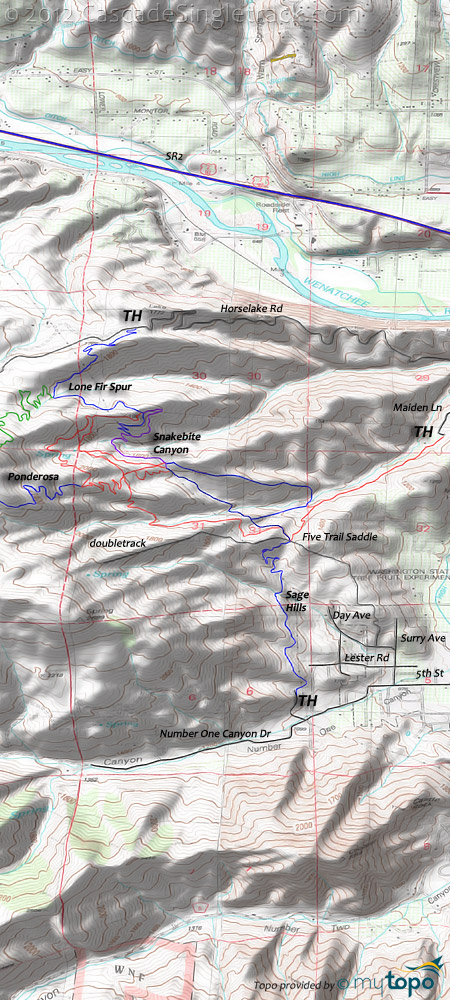
Most of the trails don't have an official name, and consist of interconnected loops and a few spurs which are used for access. Some names have been applied to various trails, either based on what they have been called or some landmark, just to assist with trail description.
Closed trails are either blocked off or signed with red-dots, and are often too steep to be used in a sustainable manner.
These are multiuser trail and expect hikers on the entire trail system.
Sage Hills is closed from December 1 to April 1, to allow mule deer to winter in the area.
All of the access points are in residential areas. The end of Sage Hills Road is closed and posted 'No Parking.'
Day Rd Parking: Go west on 5th Street .6mi past Western Ave. Go right onto Surry Ave, left onto Lester Rd, then right onto Day Rd and stay on Day Rd through a sharp left curve then a sharp right curve. Park on the left roadside, just before the 'Stay Out' signs. Go on the trail uphill from the pullout, which intersects with Lester Trail.
Overflow Parking. Park along 5th Street between Jennings St and Surry Ave.
Horselake Road and Maiden Lane parking is further away from residential areas and so less restricted. Just find a responsible place to park.
The loop described below is often done CW but the terrain is moderate enough for either direction.
Directions: Sage Hills 'Lester Trail' parking: Go west on 5th Street past Western Ave, then bear left onto Number One Canyon Rd and go .4mi to the Sage Hills Rd intersection and park alongside Number One Canyon Rd (7 car limit). View Larger Map. No Map?.

Loop Directions
rolling meadows
- TH: From Sage Hills road, climb Lester Trail (sometimes called Sage Hills Trail) to the 5-trail saddle intersection.
- 1.5mi: Bear to the left, then bear to the right at 1.6mi, onto 'Gut Saddle' trail, cross a creek and ascend to the ridgeline.
- 2.3mi: Crest the ridge then pass through several intersections onto 'Snakebite Canyon' trail. Cross a creek at 2.6mi then traverse the steep hillside to the ridgeline.
- 3.2mi: Cross the Lone Fir Spur trail intersection and pass the ride summit, descending the ridge on 'Coyote Canyon' trail, passing a 4 way intersection at 3.9mi.
- 5mi: Cross a creek at 4.3mi then continue the descent to the intersection, then bear right to go to the 5-trail saddle intersection and back to the TH.
Trail Index
This Ride
Sage Hills Trail, Foothills Trail, Gut Saddle Trail, Homestead Trail, Ponderosa Ridge Trail, Snakebite Trail
XC Ski
Trail Rankings
Ranking consistently applied to all of the listed trails.
- Overall Rating: Ride quality and challenge
- Aerobic: Ascent challenge
- Technical Difficulty: Terrain challenge
- Steepness: Average incline
- Flow: Uninterrupted riding
- Elevation Change: Total elevation gain
- Ride Difficulty: Terrain challenge


