
Pipeline Tr1200
Twitter Search
#SquilchuckTrail

Overall: 5
Aerobic: 6
Technical: 5
Steepness: 7
Flow: 6
Singletrack: 99%
Otherwise known as the Clara Lake loop, the Blewett Pass Washington Squilchuck Trail 'pipeline' loop ties into Devils Gulch Tr1220 and Mission Ridge Tr1201 for a short but steep intermediate ride.
Type
Loop
Length
Avg: 9.5mi
Ascent
Moderate
Elevation Change
TH:4650'
Avg Ascent:3000'
Ascent Incline
15%
Duration
Avg: 2hr
Weather
Forecast
NOAA
popup
USFS
A CW ride begins with Pipeline Tr1200, riding from the ski area to Clara Lake, then going left on FR9712 to Mission Rdg Tr1201 to Devils Gulch Tr1220 and back.
Could be ridden as a figure 8 with Mission Rdg Tr1201 and Devils Gulch Tr1220. Can also loop with Devils Spur Tr1203.
The Devils Gulch/Mission Ridge/Tronsen Ridge trails make the Mission Ridge ski area one of the better ski resort mountain bike destinations in the Cascade range.
The Squilchuck Tr1200 northern TH is across from the Devils Gulch Tr1220 FR240 TH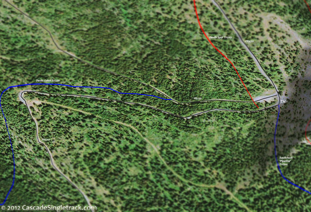
View of the Devils Gulch, Squilchuck FR9712 TH, at an unsigned small roadside pullout, next to a talus slope.
The Squilchuck 'Pipeline' Tr1200 gets some winter use by XC Skiers. From the Devils Gulch Tr1220 FR240 TH, Pipeline ascends 150' then undulates through talus fields and larch glades, traversing the hillside toward the Mission Ridge Ski Area.
From the Beehive Spring picnic area, Beehive Tr1202 ascends 2mi over moderate terrain to Devils Spur Tr1203, as a moderate warmup OAB.
Devils Spur Tr1203 (Devils Tie-In) is mostly FR7121, a hillside traverse to FR9712, with some exposure just to keep things interesting.
Directions: NW Forest Pass required right at the TH. Park at Mission Ridge ski area. View Larger Map. No Map?.

Loop Directions
on a mission
Squilchuck Pipeline Area Topo Map
- TH: Ride from the Mission Ridge Ski Area on SR711 to the Squilchuck Tr1200 TH, hike-a-bike to the T intersection and go left. After a steep climb, the terrain moderates, then pass the Clara Lake Trail intersection at 1mi. The terrain in this section is somewhat rocky and technical.
- 2mi: After a brief descent, go left on FR9712 and climb to the Mission Ridge Tr1201 TH.
- 2.7mi: At the sharp FR9712 curve (the ride summit), go right onto Mission Ridge Tr1201 and begin the fast descent to the Devils Gulch Tr1220 intersection. Pass a connector trail on the left at 3.2mi.
- 4.7mi: Pass through a minor saddle, then go right at the Devils Gulch Tr1220 fork intersection. Option: extend the ride with some Mission Ridge Tr1201 OAB.
- 7mi: After crossing East Fork Mission Creek tributaries at 5.3mi and 6.8mi, climb to FR9712 and go left .4mi to the northern Squilchuck Tr1200 TH and go right. Note: Not shown on the map but some riders use FR240 to parallel FR9712, then cross the road to Squilchuck Tr1200.
- 7.4mi: Go onto Squilchuck Tr1200, traverse the hillside over moderate terrain, and return to the TH.

Trail Index
This Ride
Beehive Trail 1202, Clara Lake Trail, Devils Gulch Trail 1220, Devils Spur Trail 1203, Mission Ridge Trail 1201, Mission Peak Trail, Squilchuck Trail 1200
Area
XC Ski
Squilchuck 'Pipeline' Tr1200
Campgrounds
Trail Rankings
Ranking consistently applied to all of the listed trails.
- Overall Rating: Ride quality and challenge
- Aerobic: Ascent challenge
- Technical Difficulty: Terrain challenge
- Steepness: Average incline
- Flow: Uninterrupted riding
- Elevation Change: Total elevation gain
- Ride Difficulty: Terrain challenge
