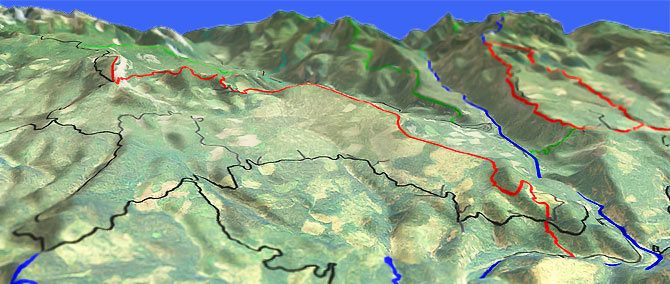
Little Bald Mountain Tr961

Overall: 6
Aerobic: 7
Technical: 5
Steepness: 6
Flow: 7
Singletrack: 100%
The Ellensburg Washington Little Bald Mtn Trail offers some smooth cliffside singletrack exposure, overlooking the William O Douglas wilderness Bumping River valley.
Type
OAB
Length
Avg: 18mi
Ascent
Intense
Elevation Change
TH:2950'
Avg Ascent:4700'
Ascent Incline
8%
Duration
Avg: 5hr
Weather
Forecast
NOAA
popup
USFS
Trail
Review
For intermediate climbers, Little Bald Mtn Tr961 is manageable as an 18mi (4700' ascent) OAB ride.
The OAB option is the suggested route for this ride, even though the road-rage version is described in the guide below.
The OAB ride requires little description, starting from the FR1709 intersection and ascending the smooth cliffside trail.
The Saddle Camp ascent loose rock trail surface will be too difficult to climb for most riders, who may choose to turnaround prior to this final section.
If the OAB seems like too much, consider shuttling between FR1709 and Saddle Camp, to avoid the 13mi fireroad grind. Watch the intersections, with many lesser fireroads crossing FR1709.
Plenty of camping options in the area, with the Halfway Flat Campground, Lindsay Campground and Indian Flat Campground close to the TH and many campgrounds along Bumping Lake FR1800.
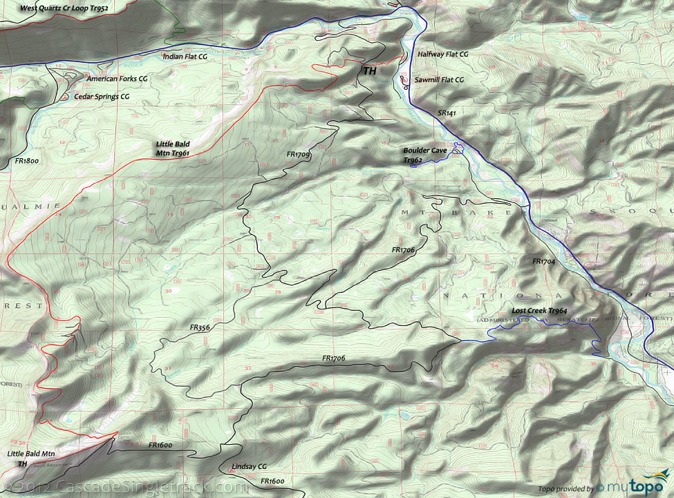
Directions: See Map. SR141 to FR1709. View Larger Map. No Map?.

Loop Directions
long climb, fast descent
- TH: From the FR1709 intersection with Little Bald Mtn Tr961, ascend 1.5mi out of the Naches River valley then continue in a moderate ascent, crossing Devil Creek at 3.2mi.
- 6.2mi: After crossing Swamp Creek, bear right onto FR1706 and continue the pine forest ascent. The ascent intensifies at 8.6mi, while traversing the Lost Creek drainage. The next 4mi ascent to Saddle Camp continues at a steady grade.
- 11.3mi: Go right onto FR1600, passing the 'Little Bald Mtn 3' sign, and complete the climb to Saddle Camp.
- 12.9mi: At the sharp left bend, go right onto Little Bald Mtn Tr961. The trail traverses to the ridgeline, reaching the ride summit at 14.3mi, with a loose, rocky trail surface which will require some hike-a-bike.
- 15.5mi: Cross FR366 at the edge of a clearcut and jog left to find the trail again. Get lost, then find the trail again and traverse the clearcut back to the ridgeline, then ride the uninterrupted ridgeline at the edge of the William O Douglas wilderness for 4mi.
- 20.2mi: The trail breaks away from the sloping ridgeline, with a traverse back to the FR1709 TH.
William O Douglas Bumping Lake Area Hiking
Bounded by SR410 to the north and Pacific Crest Tr2000-I to the west, the easily accessible Bumping Lake area is perfect for day hiking, with loop options for most skill levels.
North of Bumping Lake, American Ridge Tr958 is the main East-West connector, with trails leading to SR410 and the Pleasant Valley Loop Tr999, as well as into the Bumping reservoir basin. Either connect some trails into a loop or shuttle between FR1800 and one of the SR410 campgrounds.
To the west, Fish Lake Way Tr971A leads to a Swamp Lake Tr970 - Bumping Lake Tr971 loop around Cougar Lake, with Pacific Crest Tr2000-I as the connector.
The Deep Creek campground trails and Pear Butte Tr979 lead south to Rimrock Lake, covered on the Klickitat Tr7 page.
Mount Aix Tr982 leads to FR1500, the eastern trail boundary.
Trail Index
This Ride
Little Bald Mountain Trail 961
Area
Bear Creek Trail 943, Boulder Cave Trail 962, Fifes Ridge Trail 954, Indian Flat Trail 955, Lost Creek Trail 964, Quartz Creek Trail 949, West Quartz Creek Loop Trail 952
Wilderness
American Ridge Trail 958, Bumping Lake Trail 971, Cougar Lake Trail 958A, Dewey Lake Way Trail 968, Fish Lake Way Trail 971A, Goat Creek Trail 959, Goat Peak Trail 958C, Goose Prairie Trail 972, Kettle Creek Trail 957, Mesatchee Creek Trail 969, Mount Aix Trail 982, Nelson Ridge Trail 984, Nile Ridge Trail 974, Pacific Crest Trail 2000-I, Pleasant Valley Lake Trail 958B, Pleasant Valley Loop Trail 999, Richmond Mine Trail 973, Soda Spring Trail 975, Swamp Lake Trail 970, Twin Sisters Trail 980, Windy Ridge Trail 985
Campgrounds
American Forks Campground, Bumping Crossing Campground, Bumping Lake Campground, Cedar Springs Campground, Cottonwood Campground, Cougar Flat Campground, Crow Creek Campground, Deep Creek Campground, Halfway Flat Campground, Hells Crossing Campground, Indian Flat Campground, Jungle Creek Campground, Kaner Flat Campground, Little Naches Campground, Lodgepole Campground, Pine Needle Campground, Pleasant Valley Campground, Sawmill Flat Campground
Trail Rankings
Ranking consistently applied to all of the listed trails.
- Overall Rating: Ride quality and challenge
- Aerobic: Ascent challenge
- Technical Difficulty: Terrain challenge
- Steepness: Average incline
- Flow: Uninterrupted riding
- Elevation Change: Total elevation gain
- Ride Difficulty: Terrain challenge


