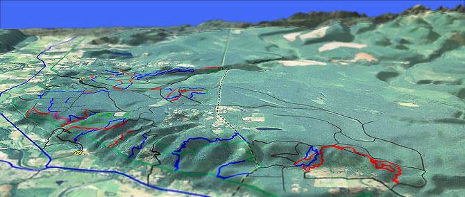
Tokul and Griffin Creek Trails
Twitter Search
#tokultrail

Overall: 5
Aerobic: 5
Technical: 4
Steepness: 4
Flow: 6
Singletrack: 70%
Tokul Creek and Griffin Creek are at the edge of the privately owned 100,000 acre Snoqualmie Washington Forest tree farm, and as of January 1, 2012 all access will require a permit, including bicycling, walking and horseback.
Type
Loop
Length
Avg: 25mi
Ascent
Moderate
Elevation Change
TH:400'
Avg Ascent:2700'
Ascent Incline
5%
Duration
Avg: 3hr
Weather
Forecast
NOAA
popup
Trail
Review
Like other tree farms, the Snoqualmie Tree Farm area consists of short trail segments connecting a lot of roads (plus the need for a $$$ permit), makes Tokul more of a local favorite than a mountainbiking destination.
Hancock Timber Resource Group will occasionally close various sections for logging, fire danger or for whatever reason they with, so be sure to pay attention to posted signs.
'Gun Range' comes with occasional sound effects, from the nearby gun range. Be sure to wear bright colors if riding in the Fall, as the area is used by local hunters, who might think their permit covers mountainbikes.
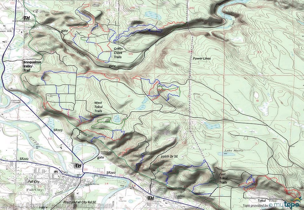
The Griffin Creek area is north of (and accessed from) East Griffin Creek road.
Some of the trails: Up In, Sarahs, Conspiracy, Beer Run, Mud Hill, Bowl, PnA, Dancers Wee Owl, Deer Sneak a Bite, Eagle Perch, Petes Cambodia Docside, Spooky Hollow, Allie Oop and Magnolia Madrona Ridge.
A typical 9.5mi (1500' ascent) CW loop consists of Petes Cambodia Docside, Spooky Hollow, Conspiracy, the Dancers Wee Owl to Deer Sneak a Bite loop, then Owl, Bowl and another go at Petes Cambodia Docside.
Some East Tokul area trails: Gun Range, Safety First, Tether Ball, Last Frontier and Flowtron 3000.
A profile map of an 10.5mi (2200', 5% ascent) East Tokul CCW Loop is shown in the guide below, which covers most of the terrain.
East Tokul TH: Park where the Snoqualmie Valley Trail intersects 356th Ave NE, or in the upper parking lot at the Falls.
Some West Tokul area trails: Bra, Tobogan, Bobsled, Kamikaze, Mouse Trap, Upper Outback, Out House, Steak House, Full Bench, Black Bear, Steep, Pink Ribbon, Bon Bon, Major Tom, and Sgt Wells.
An 11mi (1800', 6% ascent) OAB starting with Pink Ribbon, then exploring the Mouse Trap / Steak House area, returning on Kamikaze, is a typical ride.
A smaller loop could be created from Full Bench, Black Bear and the other trails in that area.
West Tokul TH: Park in Fall City and go up SE 39th Place to the Snoqualmie Valley Trail, then go northward to the trails.
The CCC Road and CCC Trail 1264 are additional nearby ride options.
The Snoqualmie Tree Farm area is actively logged so also watch out for log trucks and stay out of active logging areas.
As with all tree farms, please watch for closure and restriction signs.
Directions: See Map. I-90E to Fall City Exit 22. Go right onto SR202, towards Snoqualmie. View Larger Map. No Map?.

Loop Directions
tiny trails
- TH: From the 356th Dr SE TH, pass the Alan's Ravine intersection at .2mi and continue on Snoqualmie River Trail to the singletrack on the left at .7mi, then ascend to the doubletrack and climb to Rd 30143.
- 2.3mi: Go right on 30143 Rd, go right onto Rd 30100 then ride Safety First Tr at 2.7mi. At 3.1mi, either ride Gun Range Tr or the loop trail to the right, then return to Rd 30100.
- 4.1mi: Go left onto Tether Ball Tr, followed by Flowtron Tr. Maybe loop around this group of trails, using the doubletrack to get back to Rd 30143 (upper trailhead).
- 8.5mi: After some looping around this section of trails, ascend to Rd 30143 then go left to Alan's Ravine and descend to the TH.
Area Hiking: The Middle Fork Snoqualmie Trail 1003 page covers the nearby Baker-Snoqualmie Alpine Lakes Wilderness hiking options.
Closer in, Rattlesnake Mountain is long enough for an all day hike, Mount Si is a very popular hike and there are some hiking trails near the Twin Falls State Park for shorter excursions. WA DNR Mount Si Info.
The unmaintained Kamikaze Trail to Mount Teneriffe starts with a 1mi hike on the abandoned Mount Teneriffe road, then crosses Kamikaze creek and ascends the steep flank of Mount Teneriffe, passing the 150' Kamikaze Falls.
The Twin Falls Recreation Area is the western half of Olallie State Park. The Twin Falls trail is reputed to be the best trail in the area for families with small children, wandering alongside the South Fork Snoqualmie River before crossing at 1.1mi. The southern half of the trail is a slightly tougher climb, too much for most small children.
Trail Index
Griffin Creek
Allie Oop Trail, Beer Run Trail, Bowl Trail, Conspiracy Trail, Dancers Wee Owl Trail, Deer Sneak a Bite Trail, Eagle Perch Trail, Magnolia Madrona Ridge Trail, Mud Hill Trail, Petes Cambodia Docside Trail, PnA Trail, Sarahs Trail, Spooky Hollow Trail, Up In Trail
East Tokul
Flowtron 3000 Trail, Gun Range Trail, Last Frontier Trail, Safety First Trail, Tether Ball Trail
West Tokul
Bobsled Trail, Black Bear Trail, Bon Bon Trail, Bra Trail, Full Bench Trail, Kamikaze Trail, Major Tom Trail, Mouse Trap Trail, Out House Trail, Pink Ribbon Trail, Sgt Wells Trail, Steak House Trail, Steep Trail, Tobogan Trail, Upper Outback Trail
Area
CCC Trail 1264, Duthie Hill Trails, John Wayne Rails to Trail, Middle Fork Snoqualmie Trail 1003, Snoqualmie Valley Rails to Trail, Tapeworm Trails, Taylor Mountain Trails, Tiger Mountain Trails, Twin Falls Trail
Hiking
Green Mountain Trail, Kamikaze (to Mount Teneriffe) Trail, Little Si Trail, Mailbox Peak Trail, Mount Si Trail, Mount Washington Trail, Rattlesnake Mountain Trail, Zig Zag Trail
Trail Rankings
Ranking consistently applied to all of the listed trails.
- Overall Rating: Ride quality and challenge
- Aerobic: Ascent challenge
- Technical Difficulty: Terrain challenge
- Steepness: Average incline
- Flow: Uninterrupted riding
- Elevation Change: Total elevation gain
- Ride Difficulty: Terrain challenge


