
Tiger Mountain Trails
Twitter Search
#tigermt
#duthiehill

Overall: 5
Aerobic: 5
Technical: 5
Steepness: 6
Flow: 6
Singletrack: 80%
Tiger Mountain has 3 easily-accessible trails and is extremely popular, so expect to interact with a lot of other users.
Type
Loop
Length
Avg: 15mi
Ascent
Moderate
Elevation Change
TH:1400'
Avg Ascent:2250'
Ascent Incline
10%
Duration
Avg: 3hr
Weather
Forecast
NOAA
popup
Trail
Review

There are only a few trails open to biking, with the rest of Tiger Mountain restricted to hikers.
As if the limited singletrack weren't enough to maintain the local (non-destination) trail status, as of July 2011 a Discover Pass will be required to park at either Tiger Mountain lot. Although the terrain is fun and worth checking out, considering the cost, it's not worth driving any great distance to ride mostly fireroads. That said, for anyone seeking in-town, semi-hilly riding, the 10mi Tiger loop is an easily accessible, solid workout.
Seasonal closure: October 15 to April 15. WA DNR Tiger Mountain Status.
Duthie Trails: The 6mi Grand Ridge Trail leads from the Preston (Rails to Trail) to the Duthie park trails, with numerous stunts and skill building terrain to be found within the four CW loops.
Other than riding north from the Grand Ridge Trail, parking for Duthie Hill is also at the Duthie Hill Lodge (upper lot) or Cascade Ridge Elementary on the weekend. View of Duthie Hill TH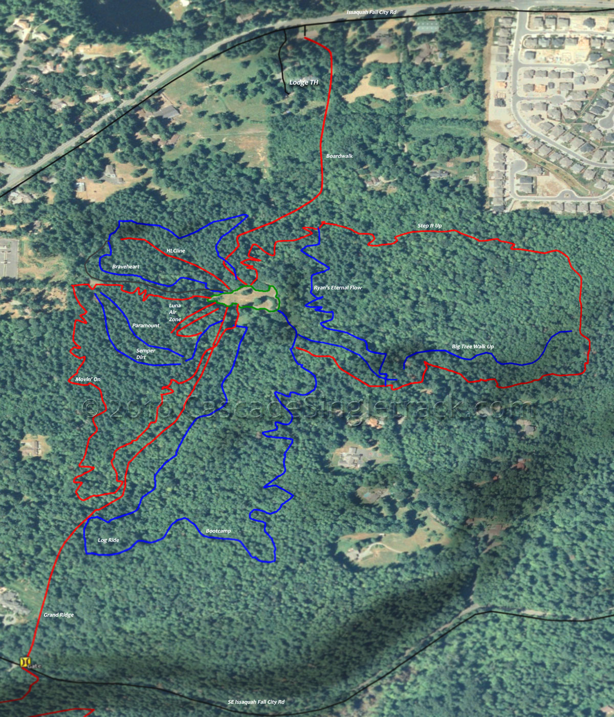
View of Duthie Hill TH.
The Evergreen MTB Duthie Hill page has the current status of the MTB park and notes on the skill building features of the park.

Off The Grid Trail is more technically challenging (roots and rocks, with some large drops) than Preston RR Grade and NW Timber. A 13mi OTG loop combines the usual ascent to the East Tiger Summit, then OTG with Fully Rigid and Joyride and a return on NW Timber.

Nearby Taylor Mountain has even more singletrack open to bikers, so is worth checking out.
For those interested in helping maintain the Tiger, Duthie and other area trails, there are frequent work parties which help keep these trails rideable.
Tiger Mountain Hiking: The 6.5mi (2200' ascent) Chirico to Poo Poo Point CCW Loop is a popular hike, as are the obvious loop options from the various northern trailheads.
The 14.5mi (4950' ascent) Tiger Mountain Trail is the primary N-S connector for most other trails and a popular route for those seeking an all-day hike. The route is usually done South to North and includes some Hobart rails to trail on the way to the Karl's Gap Tiger summit.
Directions: See Map. I-90E to SR18S. Go 4.4mi to the East Tiger Summit parking area. View Larger Map. No Map?.


Loop Directions
east side ride
- TH: From the TH, ascend the Main Tiger Rd 4000 to the Preston Railroad Trail intersection.
- 2.9mi: Go right onto Preston Railroad Trail and work the switchback descent to RD 7500, crossing the East Tiger Mountain Trail at 3.6mi.
- 6mi: At the Y intersection with Crossover Rd 5500 and Rd 7500, go to Rd 7500 and traverse the flank of East Tiger Mountain to the Northwest Timber Trail, crossing a creek at 7.4mi.
- 7.6mi: Go right onto Northwest Timber Trail and parallel the powerline back to the TH.

Trail Index
This Ride
East Tiger Summit Trail, Fully Rigid Trail, Iverson RR Trail, Joyride Trail, Northwest Timber Trail, Off The Grid Trail, Preston RR Trail, Silent Swamp Trail
Taylor Mountain
Beaver Pond Trail, Boot Trail, Carey Creek Trail, Elk Ridge Trail, Hermit Trail, Holder Creek Trail, Holder Knob Trail, Holder Ridge Trail, Knee Knocker Trail, Mount Beaver Trail, Sherwood Trail, Watershed Trail, Whiskey Still Trail
Griffin Creek
East Tokul
West Tokul
Area
Boardwalk Trail, Bootcamp Trail, Braveheart Trail, CCC Trail 1264, Duthie Hill Trails, Grand Ridge Trail, John Wayne Rails to Trail, Middle Fork Snoqualmie Trail 1003, Movin On Trail, Ryan's Eternal Flow Trail, Snoqualmie Valley Rails to Trail, Step it Up Trail, Tapeworm Trails, Twin Falls Trail
Tiger Mtn Hiking
Adventure Trail, Artifacts Trail, Big Tree Trail, Bootleg Trail, Brink Trail, Bus Trail, Cabeline Trail, Chirico Trail, Dwight's Way Trail, East Tiger Mountain Trail, Fifteenmile RR Grade Trail, Hidden Forest Trail, High Point Trail, High School Trail, Hobart Grade Trail, Hobart Middle Tiger RR Grade Trail, Lingering Loop Trail, Middle Tiger Trail, Nook Trail, North Side RR Grade Trail, One View Trail, Poo Top Trail, Poo Poo Point Trail, Preston Trail, Puget Power Trail, Raging River Trail, Round the Lake Trail, Seattle View Trail, Section Line Trail, Silent Swamp Trail, Swamp Trail, Talus Rocks Trail, West Tiger 1 Trail, West Tiger 3 Trail, West Tiger RR Grade Trail
Trail Rankings
Ranking consistently applied to all of the listed trails.
- Overall Rating: Ride quality and challenge
- Aerobic: Ascent challenge
- Technical Difficulty: Terrain challenge
- Steepness: Average incline
- Flow: Uninterrupted riding
- Elevation Change: Total elevation gain
- Ride Difficulty: Terrain challenge
