White Rabbit Tr1002
Twitter Search
#whiterabbittrail

Overall: 6
Aerobic: 7
Technical: 6
Steepness: 7
Flow: 5
Singletrack: 75%
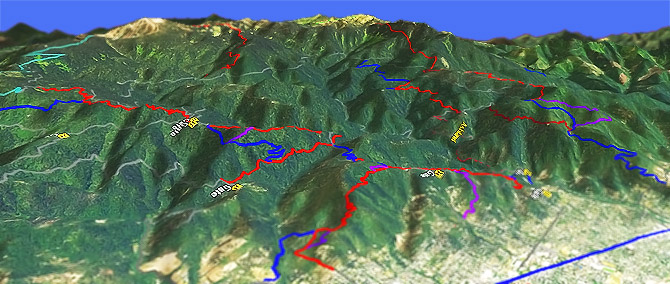
The Ashland Oregon White Rabbit Trail connects to the Ashland wastershed Loop Road, with many descent options.
Type
Loop
Length
Avg: 14mi
Ascent
Intense
Elevation Change
TH:2450'
Avg Ascent:5500'
Ascent Incline
14%
Duration
Avg: 4hr
Weather
Forecast
NOAA
popup
USFS
The Ashland watershed is an actively managed trail complex, with frequent name changes and trail modification over time (some trail references may be outdated).
There are several trailheads, including two for White Rabbit Tr1002 (Park St and Lupine Dr). Granite St and Tolman Creek Rd are also popular, depending on the ride.
On the western slope, Horn Gap Tr1014 offers hillside exposure and narrow tread, with tight switchbacks and steep terrain.
To the West, the Wagner Creek area offers accessible terrain.
XC Skiing: The Bull Gap Snopark is at the intersection of FR2080 and FR200. Bull Gap Trail 1017 or FR200 get some use by XC Skiiers.
Pacific Crest Trail Hiking
To the south, Pacific Crest Tr2000-A parallels FR20 (CR1151) past Mouunt Ashland. Hikers can also ascend Wagner Butte (Wagner Butte Tr1011), or Mount Ashland on Bull Gap Trail 1017.
Contact Rogue Valley MTB Assn if interested in helping with trail maintenance or other activities and information.
The hiking-only Mike Uthoff trail parallels White Rabbit. There are other hiking trails downhill from FR2060.
Directions: The Upper TH is on FR2060: SR66 (Ashland Street) for 1mi, then go right onto Siskiyou Blvd. and go .75mi to Morton St (a few blocks past Triangle Park). Go left onto Morton, to the top of the hill. Go sharp left onto Ashland Loop Rd, which turns to gravel. Go 1mi to TH. View Larger Map. No Map?.

OAB Directions
ashland loop
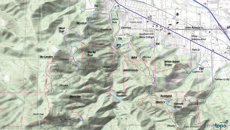
- TH: From the Lupine Street TH, cross Hamilton Creek then pass the connector to the Park St TH. Ascend the sharp and steep switchbacks to a bench. Continue on to the 3way intersection with Caterpillar Tr1004 and the Queen of Hearts loop.
- 2.1mi: Go left on FR2060 Ashland Loop Rd and ascend to the FR200 intersection.
- 4.9mi: Go straight through the 5way intersection, onto FR200. Ascend to the FR270 Upper Lynx TH.
- 7.1mi: Go onto FR270 then onto Upper Lynx and descend the watershed boundary ridgeline, passing the Eastview Tr1012 intersection at 7.9mi.
- 9.5mi: Pass through the 5way intersection, continue north on FR2060 for 0.1mi, then go right onto Marty's. (Catwalk Tr1003 descends from this intersection).
- 10.8mi: Cross FR2060 onto Caterpillar Tr1004 and descend through the narrow switchbacks and across FR2060 to White Rabbit Tr1002.
- 12.4mi: Go right onto the Queen of Hearts loop then descend White Rabbit Tr1002 to the TH.
Trail Index
This Ride
Caterpillar Trail 1004, Lynx Trail, Marty's Trail, Queen of Hearts Loop, White Rabbit Trail 1002
Area
Alice in Wonderland Trail, Bike Wash Trail, BTI Trail, Catwalk Trail 1003, Eastview Trail 1012, Hitt Road, Horn Gap Trail 1014, Lamb Mine Trail 1015, Mystical Trail, No Candies Trail, Time Warp Trail, Toothpick Trail, Wagner Creek Trail
Hiking
Bull Gap Trail 1017, Pacific Crest Tr2000-A, Wagner Butte Trail 1011
XC Ski
Bull Gap Trail 1017, Crest Loop Trail
Campgrounds
Mount Ashland Campground
Trail Rankings
Ranking consistently applied to all of the listed trails.
- Overall Rating: Ride quality and challenge
- Aerobic: Ascent challenge
- Technical Difficulty: Terrain challenge
- Steepness: Average incline
- Flow: Uninterrupted riding
- Elevation Change: Total elevation gain
- Ride Difficulty: Terrain challenge


