Blue Lake Tr3422
Twitter Search
#MountJeffersonWilderness

Overall: 5
Aerobic: 5
Technical: 6
Steepness: 5
Flow: 5
Singletrack: 100%
The Detroit Oregon Blue Lake Trail is in the Mount Jefferson Wilderness, so only open for hiking and Nordic activities. The Middle Santiam Wilderness page includes several trails open to biking (outside the wilderness boundary), which are part of the 2020 Oregon Timber Trail Cascade Peaks route.
2020 Beachie Creek, Lionshead & Holiday Farm Fires: The northern portion of the Detroit RD and a portion of the McKenzie River RD were damaged by the fires. See the NF Site for closures.
As always, it is best to call the local Ranger District for trail conditions and other restrictions prior to visiting the area, as the NF website may not contain trip-specific or current details.
Type
Loop
Length
Avg: 17mi
Ascent
Moderate
Elevation Change
TH:4600'
Avg Ascent:2850'
Ascent Incline
5%
Duration
Avg: 4hr
Weather
Forecast
NOAA
popup
USFS
With many interconnecting trails, the terrain is well suited for XC Ski and day hikes.
Starting in 2021, the Mt. Jefferson, Mt. Washington, and Three Sisters Wilderness Areas will require a Central Cascades Wilderness Permit for Day or Overnight use, from May 28th to Sept 24th.
As with many other west-side Cascade ranger districts, there are few biking trails in the Detroit or Sweet Home ranger districts.
The SR20 and SR22 trailheads offer relatively easy access to the area and the elevation gains are moderate enough for intermediate hikers.
Marion Forks is the largest CG in the area, with smaller campgrounds at Fay Lake, Lost Lake and Camp Pioneer. Riverside CG is just north of Marion Forks CG, on SR22.
Equestrians: Several Horse Camps are shown on the maps and the easily accessible Santiam Wagon Road Tr3413, a scenic, wooded doubletrack trail which extends from Lebanon to the Deschutes NF. Portions of this trail are also well suited for novice bikers and family outings.
The Middle Santiam Wilderness is west of SR20 and north of SR22, with a vast area to explore. The Crescent and Pyramid Mountains are the most easily accessible, with ridgeline terrain continuing on to Knob Rock and Chimney Peak, for those able to set up a shuttle.
Marion Lake Loop
2003 B&B complex fire: This area continues to have downed trees, blocking Bowerman Lake Trail 3492 and a risk on other area trails.
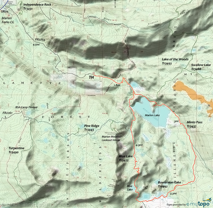
This 14mi (2800' ascent) CW loop skirts the eastern side of Marion Lake, then traverses the Horse Pasture Creek drainage on Minto Pass Tr3437, to Bowerman Lake Tr3492.
The 5350' loop summit is just north of Blue Lake, while crossing the Jack Creek headwaters (while traversing the Marion Mountain ridgeline), with a steep descent past the Pine Ridge Tr3443 intersection, to Marion Falls.
Blue Lake to Marion Lake is relatively steep so this day hike works better as a CW loop.
Mosquitoes are ferocious in this area until August. Feel free to try the natural repellents, and avoid drinking carbonated drinks prior to hiking, but Deet 100 may be the only protection from 'the swarm'.
Directions: See Map. View Larger Map. No Map?.

Loop Directions
Turpentine, Duffy, Marion loop
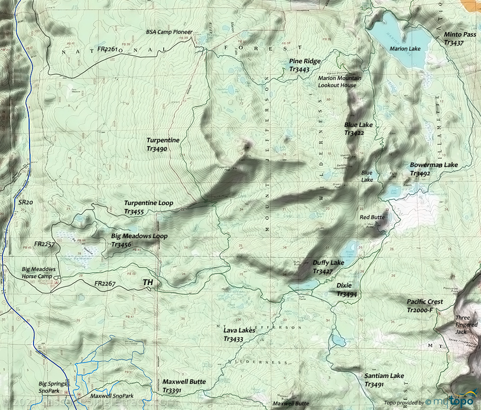
- TH: Park at the Camp Pioneer, Fay Lake TH or Duffy Lake TH, and hike the Blue-Turpentine loop CCW, as Blue Lake Tr3422 is a steep descending traverse of the Marion Mountain ridgeline.
Middle Santiam Wilderness
FR11 to the north and SR20 to the south enables relatively easy access to this popular four-season wilderness area.
SR20 has a number of sno-parks, with the Tombstone SnoPark at 4200' and the other sno parks in the low 4000' elevations, well suited for XC Skiing.
The road is dangerous and sometimes unexpectedly snowed in during the winter, requiring a 4WD and chains. If possible, bring winter camping gear (tent, bag, stove, light, food), to cover any unintended overnight stays. Arrive with a full gas tank, and bring a GPS and other supplies in case of emergency.
Oregon Timber Trail: The trails to the east of the Middle Santiam Wilderness area are part of the OTT 2020 Cascade Peaks route (route may change over time). The 2020 route was Santiam Wagon Road Tr3413 to Crescent Mountain Tr3384 to South Pyramid Creek Tr3403 to Chimney Peak Tr3382 to Gordan Peak Tr3387 to Scar Mountain Tr3402, then FR1162 to FR2236 to SR22.
Chimney Peak Tr3382 crosses the unbridged Middle Santiam, then wanders through old growth forest to Donaca Lake and on to Chimney Peak.
The rocky crags of the Pyramids are the primary area geological feature, with steeply wooded slopes leading to a series of open meadows. Access roads make this a good shuttle-hike choice, possibly combines with Crescent Mountain Tr3384.
Far more rugged and remote, McQuade Creek Tr3397 is more difficult to access, but can also be set up as a shuttle-hike.
Consider Chimney Peak Tr3382, Swamp Peak Tr3401 and Gordan Peak Tr3387 for a loop, possibly requiring as an overnight trip. The far larger loop, which includes Scar Mountain Tr3402.
Trail Index
Oregon Timber Trail Biking
Chimney Peak Trail 3382, Crescent Mountain Trail 3384, Gordan Peak Trail 3387, Scar Mountain Trail 3402, South Pyramid Creek Trail 3403
Mount Jefferson Wilderness Hiking
Big Meadows Loop Trail 3456, Big Meadow Tie Trail 3434, Bingham Ridge Trail 3421, Blue Lake Trail 3422, Bowerman Lake Trail 3492, Dixie Trail 3494, Duffy Prairie Trail 3454, Duffy Lake Trail 3427, Independence Rock Trail 3431, Lake of the Woods Trail 3493, Lava Lakes Trail 3433, Lava Lake Access East Trail 4151, Marion Lake Trail 3436, Marion Mountain Trail 3435, Marion Outlet Trail 3495, Maxwell Butte Trail 3391, Minto Pass Trail 3437, Pacific Crest Trail 2000-F, Pika Fir Trail 3489, Pine Ridge Trail 3443, Red Butte Trail, Santiam Trail 3491, Santiam Lodge Trail 3496, Swallow Lake Trail 3488, Temple Lake Trail 3444, Turpentine Loop Trail 3455, Turpentine Trail 3490, Upper Berley Lake
Area
Bear Point Trail 3342, Big Meadow Tie Trail 3434, Bruno Meadows Trail 3424, Bugaboo Ridge Trail 3423, Cheat Creek Trail 3441, Coffin Lookout Trail 3392, Crag Trail 3364, Grizzly Peak Trail 3428, Hunts Creek Trail 3440, Independence Rock Trail 3431, Lake of the Woods Trail 3493, Marion Trail 3436, McKenzie River Trail 3507, Pacific Crest Tr2000-F, Pamelia Trail 3439, Roaring Creek Trail 3361, South Breitenbush Trail 3375, South Breitenbush Gorge Trail 3366, Swallow Lake Trail 3488, Tombstone Nature Trail 3420, Triangulation Trail 3373, Whitewater Trail 3429, Woodpecker Trail 3442
Middle Santiam Wilderness & Area Hiking
Chimney Peak Trail 3382, Cone Peak Trail 3408, Daly Lake Trail 3385, Echo Basin Trail 3410, Iron Mountain Trail 3389, McQuade Creek Trail 3397, North Pyramid Trail 4161, Parish Lake Trail 3383, Pyramids Trail 3380, Riggs Lake Trail 3388, Rooster Rock Trail 3399, Swamp Peak Trail 3401, Tombstone Nature Trail 3420, Trout Creek Trail 3405
XC Ski and Snoparks
Big Springs Loop Tr4152, Lava Lake Access East Tr4151, Big Springs SnoPark, Lava Lakes SnoPark, Maxwell SnoPark, Ray Benson SnoPark, Santiam SnoPark, Tombstone SnoPark
Campgrounds
Big Meadows Horse Camp, BSA Camp Pioneer, Fay Lake Campground, Fernview Campground, Fish Lake Campground, House Rock Campground, Lost Lake Campground, Lost Prairie Campground, Marion Forks Campground, Riverside Campground, Sevenmile Horse Camp, South Pyramid Horse Camp, Trout Creek Campground, Yukwah Campground
Trail Rankings
Ranking consistently applied to all of the listed trails.
- Overall Rating: Ride quality and challenge
- Aerobic: Ascent challenge
- Technical Difficulty: Terrain challenge
- Steepness: Average incline
- Flow: Uninterrupted riding
- Elevation Change: Total elevation gain
- Ride Difficulty: Terrain challenge


