Galbraith Mountain Trails
Twitter Search
#galbraithmountain
#wmbcmtb

Overall: 5
Aerobic: 5
Technical: 6
Steepness: 5
Flow: 7
Singletrack: 95%
The Bellingham Washington Lookout Mountain, aka Galbraith Mountain, is an extremely popular tree farm trail system.
Type
Loop
Length
Avg: 9.5mi
Ascent
Easy
Elevation Change
TH:750'
Avg Ascent:2100'
Ascent Incline
6%
Duration
Avg: 2hr
Weather
Forecast
NOAA
popup
Trail
Review
Certainly not a destination trail system but well worth visiting for a day trip, with some XC terrain accessed from the Birch Street TH and an ever-expanding collection of stunts and wild, hand-built terrain at the southern end of the trail system.
The maps don't reflect every single trail and degraded trails are occasionally shut down. Please respect the signage and note that this tree farm is actively logged, with closure notices posted.
The Whatcom Mountain Bike Coalition works with the Trillium Corporation for MTB use of the tree farm.
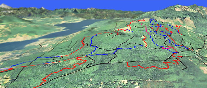
Although there are no defined loops, the two defined on this page are commonly ridden and show a typical terrain profile for most rides. It's possible to hook up enough terrain to ride 15mi, but 10mi rides are more typical.
The southern 'Galbraith Lane' terrain is steeper and made more technical by the construction of stunts and ramps. Due to the stunts, many of those trails are intended to be ridden downhill, so try to use the area south of RD2000 as downhill-only.
The local bike shops usually are the best source for the latest maps, or just go out and see what there is to ride.
Directions: See Map. Galbraith Lane: I-5 exit 252 to Samish Way to the TH, just past Lake Padden Estates. Whatcom Falls TH: I-5 exit 253 and merge onto King Street, then go left onto Lakeway Dr and go 1.8mi to the Whatcom Falls parking lot, or park along Birch Street. View Larger Map. No Map?.

Loop Directions
tower loop
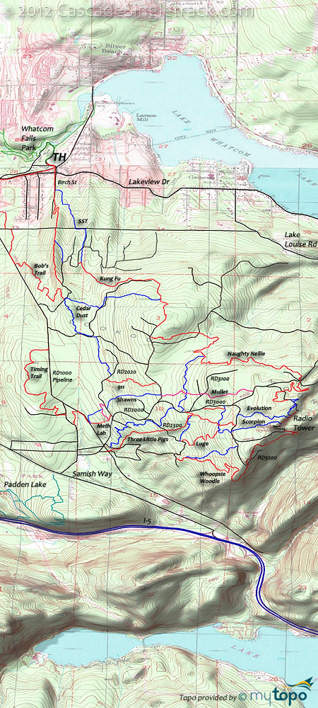
Galbraith Mountain Area Topo Map
- TH: Ascend Galbraith Lane .6mi then go right onto singletrack which leads to Meth Lab. Ascend to RD2020, then dog leg left to Not Shawns and ascend to Mullet, crossing a spur road at 1.8mi.
- 2mi: Go left on Kaiser, then go right onto Naughty Nelly at 2.6mi and climb to the 4.6mi RD4100 Wonderland intersection and ride to the towers.
- 5.1mi: At the tower ride summit, descend RD3000 to Whoopsie Woodle, then descend to the RD2300 intersection.
- 7.4mi: Go right onto RD2300 and ride to Brick Stick at 7.9mi and go left, descending to RD2100 then RD2000 back to the TH.
- Options: This is the general route but there are many, many little trails within the section covered by this loop, depending on ones desire to get airborne.
Trail Index
This Ride
911 Trail, Bob's Trail, Brick Stick Trail, Cedar Dust Trail, Connector Trail, Dans Trail, Electric Avenue Trail, Evolution Trail, Flying Squirrel Trail, Jaws Trail, Kaiser Trail, Kung Fu Trail, Luge Trail, Meth Lab Trail, Mullet Trail, Naughty Nellie Trail, Scorpion Trail, Not Shawn's Trail, SST Trail, Sht Trail, Three Little Pigs Trail, Timing Trail, Tower Trail, Wonderland Trail, Whoopsie Woodle Trail
Area
British Army Trail, Chuckanut Ridge Trail, Double Black Diamond Trail, Fragrance Lake Trail, Hemlock Trail, Incline Trail, Interurban Trail, Lily Lake Trail, Lost Lizard Trail, Madrone Crest Trail, Max's Shortcut Trail, North Butte Trail, North Lost Lake Trail, Oyster Trail, Pine Cedar Lakes Trail, Salal Trail, Rock Trail, Samish Overlook Trail
Trail Rankings
Ranking consistently applied to all of the listed trails.
- Overall Rating: Ride quality and challenge
- Aerobic: Ascent challenge
- Technical Difficulty: Terrain challenge
- Steepness: Average incline
- Flow: Uninterrupted riding
- Elevation Change: Total elevation gain
- Ride Difficulty: Terrain challenge


