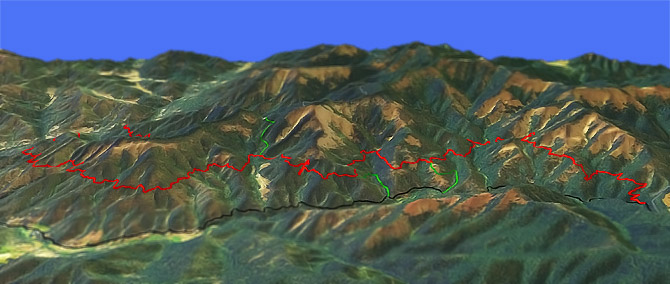
Sterling Mine Ditch Trail
Twitter Search
#sterlingmineditch

Overall: 6
Aerobic: 5
Technical: 5
Steepness: 3
Flow: 7
Singletrack: 100%
Managed by BLM, the Sterling Mine Ditch was built in 1877 to bring water from the Little Applegate River to power hydraulic mining.
Type
OAB
Length
Avg:34.5mi
Ascent
Moderate
Elevation Change
TH:2500'
Avg Ascent:2350'
Ascent Incline
5%
Duration
Avg:6 hr
Weather
Forecast
NOAA
popup
BLM
The Little Applegate Recreation Site is often used as the TH, although that results in a slightly inverted ride profile.
The berm follows the terrain, resulting in a relatively smooth ride even while traversing many hillside drainages. In places the berm has eroded to ditch level.
Berm riding presents some hillside exposure, which may be too challenging for beginners. The trail leaves the ditch at the eastern terminus, with other diversions to avoid erosion.
The southern exposure and drainage provided by the bern make it possible to ride year round.
The ride passes through typical Siskiyou forest, with oak, madrone, manzanita, and pine..and poison oak. So be careful if wandering away from the trail.
Contact Rogue Valley MTB Assn if interested in helping with trail maintenance or for trail information.
Directions: See Map. SR238 to Upper Applegate Rd to Little Applegate Rd to the Little Applegate Recreation Site. View Larger Map. No Map?.

OAB Directions
feel the berm
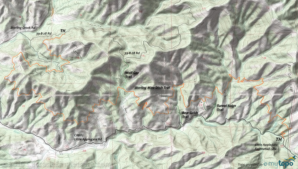
Sterling Mine Ditch Area Topo Map
- TH: From the Little Applegate Recreation Site, ascend 1400' in 2.6mi to a Goat Cabin Ridge spur, followed by a descent to Muddy Gulch and on to the Tunnel Ridge Trail intersection.
- 5mi: Pass the Tunnel Ridge Trail intersection, then traverse Bear Gulch.
- 7mi: Pass the Bear Gulch Trail intersection and go through some switchbacks (few hundred feet ascent), then descend to Wolf Gulch.
- 9mi: Pass the Wolf Gap Trail intersection. Cross McCormick Gulch at 11.3mi, then the Cantrall Gulch drainage at 12mi.
- 15.5mi: Cross 39-2-17 Rd, cross Armstrong Gulch and continue on to the Deming Gulch TH.
- 17.2mi: At the Deming Gulch TH, return to the TH, shuttle, or return on the road.
Trail Index
This Ride
Sterling Mine Ditch Trail
Hiking
Bear Gulch Trail, Tunnel Ridge Trail, Wolf Gap Trail
Campgrounds
Flumet Flat Campground, Jackson Campground, Little Applegate Recreation Site, Wrangle Campground
Trail Rankings
Ranking consistently applied to all of the listed trails.
- Overall Rating: Ride quality and challenge
- Aerobic: Ascent challenge
- Technical Difficulty: Terrain challenge
- Steepness: Average incline
- Flow: Uninterrupted riding
- Elevation Change: Total elevation gain
- Ride Difficulty: Terrain challenge


