Uno Peak Tr1260

Overall: 6
Aerobic: 7
Technical: 6
Steepness: 7
Flow: 5
Singletrack: 100%
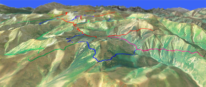
The Chelan Washington Safety Harbor Creek Trail and Uno Peak Tr1260 combine as a challenging backcountry CCW Loop.
Type
Loop
Length
Avg: 14mi
Ascent
Mt Goat
Elevation Change
TH:4300'
Avg Ascent:4650'
Ascent Incline
14%
Duration
Avg: 4hr
Weather
Forecast
NOAA
popup
USFS
Trail
Review
Safety Harbor Creek can be dangerous during spring and early summer runoff, and switchbacks up into the Big Goat Mountain and Uno Peak area.
The track is narrow in spots, the side slope is occasionally steep, and the switchbacks have a very short turning radius.
Ding: The FR8200 TH is 22.5mi from Manson SR150 and is an unimproved road which traverses six drainages, so a high clearance vehicle is strongly recommended. The area is popular with Fall hunters, so leave the antler-helmet in the car.
A shuttle can be set up from the South Navarre CG TH, avoiding a 1.5mi 1000' Safety Harbor Creek ascent.
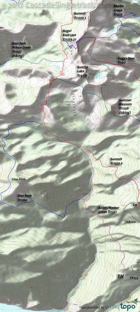
The usual ride is a CCW Lollipop loop, ascending on Safety Harbor Creek Tr1261, then riding Summit Tr1259.3 to the Uno Peak Tr1260 return.
East Fork Prince Creek Tr1257 offers a very challenging hiking loop, with a 2mi, 2000' ascent out of East Fork Prince Creek (hiking in either direction).
A more reasonable day-hike can be found on the 5.2mi Summer Blossom Tr1258, which ascends 1400' from FR8200 to North Navarre Peak. The trail then continues along Sawtooth Ridge to Summit Tr1259.3, passing Sunrise Lake Tr417B along the way.
Directions: NW Forest Pass required right at the TH. From Chelan, go on SR150 for 6mi, then go right onto Wapato Lake Road and continue until the Upper Joe Creek Road. Go right onto Upper Joe Creek Road, which becomes FR8200 (Grade Creek Road) and continue for 22.5mi to FR153. Go 2mi to the Safety Harbor Creek TH. View Larger Map. No Map?.

Loop Directions
uno safety
- TH: Start the Safety Harbor Creek Tr1261 ride with a 300' ascent from the FR155 TH, then traverse the Nelson Butte flank on an unmaintained aqueduct access road, to Safety Harbor Creek.
- 2.8mi: Reach the creek and pass the Uno Peak Tr1260 intersection on the left, pass a small dam on the left, while ascending the Safety Harbor Creek drainage 1100' to the Summit Tr1259.3 intersection. Cross a creek at 4.2mi and just prior to the Summit Tr1259.3 intersection.
- 4.7mi: Go left onto Summit Tr1259.3 and continue the steep ascent, as Summit Tr1259.3 gradually traverses the Safety Harbor Creek drainage.
- 5.8mi: Go left onto Uno Peak Tr1260 at the Miners Basin CG, with a more gradual ascent to the 7.5mi East Fork Prince Creek Tr1257 intersection and ride summit. Cross a creek at 6.4mi and 6.9mi. Pass Uno Peak at 8.3mi as the descent intensifies.
- 11.4mi: After a very steep descent, cross a tributary, then cross Safety Harbor Creek, and go right onto Safety Harbor Creek Tr1261 for the relatively flat ride back to the TH.
Trail Index
This Ride
Safety Harbor Creek Trail 1261, Summit Trail 1259.3, Uno Peak Trail 1260
Area
Angel Staircase Trail 1259.32, Crater Creek Trail 416, Eagle Lake Trail 431, Foggy Dew Trail 417, Foggy Dew Ridge Trail 438, Lower Eagle Lake Trail 431B, Martin Creek Trail 429, Martin Lake Trail 429A, Prince Creek Trail 1255.1, Upper Eagle Lake Trail 431A
Wilderness
Bernice Lake Trail 1259.14, East Fork Prince Creek Trail 1257, Fish Creek Trail 1248, Hoodoo Pass Trail 1259.31, Hoodoo Spur Trail 1255.12, Horton Butte Trail 1250.1, Indianhead Basin Trail 1250, Lakeshore Trail 1247, North Fork Prince Creek Trail 1254, Prince Creek Trail 1255, Summer Blossom Trail 1258, Summit Trail 1259, Sunrise Lake Trail 417B, Surprise Lake Trail 1249
Campgrounds
Black Pine Lake Campground, Crater Creek Campground, Cub Lake Campground, Foggy Dew Campground, Miners Basin Campground, Moore Point Campground, Prince Creek Campground, South Navarre Campground, Surprise Lake Campground
Trail Rankings
Ranking consistently applied to all of the listed trails.
- Overall Rating: Ride quality and challenge
- Aerobic: Ascent challenge
- Technical Difficulty: Terrain challenge
- Steepness: Average incline
- Flow: Uninterrupted riding
- Elevation Change: Total elevation gain
- Ride Difficulty: Terrain challenge


