
Siouxon Creek to Huffman Peak Tr130
Twitter Search
#siouxoncreektrail

Overall: 8
Aerobic: 7
Technical: 7
Steepness: 6
Flow: 6
Singletrack: 100%
Washingtons Siouxon Cr Tr130 and Huffman Pk Tr129 form a perfect loop ride, connected by Chinook Cr Tr130A and the aptly named Connector Tr130D.
2020 Big Hollow Fire: The Siouxon area was damaged by the fire. See the NF Site for closures.
As always, it is best to call the local Ranger District for trail conditions and other restrictions prior to riding, as the NF website may not contain trip-specific details.
Type
Loop
Length
Avg: 17mi
Ascent
Intense
Elevation Change
TH:1300'
Avg Ascent:5000'
Ascent Incline
11%
Duration
Avg: 4hr
Weather
Forecast
NOAA
popup
USFS
Trail
Review

Huffman Peak Tr129 crosses Siouxon Peak and Huffman Peak then descends and crosses Siouxon Creek. Riders will find that Chinook Creek Tr130A is the best way to access Huffman Peak Tr129. Expect to hike 70% of Chinook Creek Tr130A, with many 20% grades along the way. Upper Chinook Creek Tr130A is an abandoned forest road so is a moderate ascent.
Note: This is a dry weather ride. Due to the sometimes dangerous Chinook and Siouxon Creek water crossings, don't attempt the full loop right after a rainfall or before July. The steep terrain results in significant treefall, so be sure to check trail conditions.
Consider packing some rubber water shoes for the two creek crossings (Chinook and Siouxon).
Hiking options: consider using Wildcat Cr Tr156 to shorten the hike and the Huffman Pk Tr129 section can be extended by using the inverted N Fork Siouxon Tr126 (or just hike a portion OAB, to avoid the steep mid-trail North Siouxon Creek ravine).
North Fork Siouxon Tr126 is often not maintained and is not really suitable for riding.

The Siouxon Creek Tr130 OAB is 16.4mi, with half of the ascent in the last 2mi to the upper TH. The lower portion is an easy intermediate ride, becoming progressively more advanced beyond the Chinook Creek Tr130A intersection. Connector Tr130D offers some nice singletrack and past the Chinook Creek Tr130A intersection, Siouxon Creek Tr130 narrows to a technical singletrack.
Road access to the upper TH is rough and windy, making the 8.2mi shuttle ride undesirable unless arriving from the East (Wind River Road to FR64 to FR58 to upper TH).

Prior to trying the 6.4mi (2500' climbing, CW loop) Horseshoe Ridge Tr140, check with the Chelatchie ranger station to see how many years it has been since the trail was last maintained.
The first 1.7mi ascends 1600', for an unclimbable 18% grade.
The final 1.4mi descends 2100' (28% grade), in a more technical downhill than most riders are looking for.
The trail also offers steep cliff exposure, just to keep things interesting.

Directions: SR503 is the best route to Chelatchie from the north or south. Alt: At the Woodland I-5 exit, take E. CC St to N.W. Hayes Rd (Co. Rd. 16) to N.E. Cedar Cr., and go 19mi through Amboy to Chelatchie. In Chelatchie go past the ranger station, then go right on N.E. Healy Road and continue for 7 miles. Go right at the fork, through the GPNF boundary and onto FR54. At the next fork, go left onto FR57 (Calamity Pk Rd) then left onto FR5701. The Huffman TH is on the left about 50yds past a sharp right-hand bend in the road, with the Siouxon TH at the end of FR5701. View Larger Map. No Map?.


Loop Directions
creek to peak
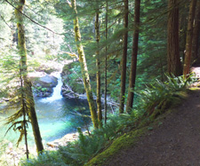
- TH: Starting from the end of FR5701, descend the steep switchbacks to the creek and go right onto Siouxon Tr130. A rustic log bridge crosses West Creek after descending from the trailhead. 1mi further on Siouxon Tr130, the surging waterfall forms a large emerald green pool with tan step-like rocks at the banks, with plenty of moss, big clover and ferns.
- 3.1mi: Horseshoe Rdg Tr140 intersection. Please check conditions before riding this trail.
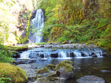
- 3.8mi: Go left onto Chinook Creek Tr130A and climb 3.2mi to Huffman Pk Tr129. A rustic Siouxon Cr log bridge marks the beginning of the trail, with a water crossing through Chinook Cr, .75mi from the TH. Water can be 3' in early July, so proceed with caution. Navigate the Chinook Creek waterfall crossing, then ascend 1000' in 1mi, through second-growth conifers and old-growth forest.
- 7mi: At FR6403, go left onto Huffman Pk Tr129.
- 9mi: After .4mi of very steep switchbacks, reach the Siouxon Peak summit trail (on the left). In .2mi reach N Fork Siouxon Tr126, which loops back to Huffman Pk Tr129 but includes a 1500' descent and climb out of the North Fork Siouxon Creek drainage. Consider a 2mi OAB extension.
- 10mi: Wildcat Creek Tr156 intersection. Wildcat crosses Wildcat Ridge then descends steeply to the 75' Wildcat Creek falls, but ends on the north side of Siouxon Creek, requiring a water crossing to get back onto Siouxon Tr130. Be sure to check the creek level on the way up, prior to descending Wildcat Tr156.
- 11.6mi: Pass the N Fork Siouxon Tr126 TH and begin the 4mi, 2600' descent to Siouxon Creek.
- 15.7mi: After crossing Siouxon Creek, climb 350' out of the drainage area through a series of switchbacks, then go left onto Connector Tr130D and continue 1.5mi back to the TH.


Trail Index
This Ride
Chinook Trail 130A, Horseshoe Ridge Trail 140, Huffman Peak Tr129, North Fork Siouxon Trail 126, Siouxon Trail 130, Wildcat Trail 156
Campgrounds
Canyon Creek Campground
Trail Rankings
Ranking consistently applied to all of the listed trails.
- Overall Rating: Ride quality and challenge
- Aerobic: Ascent challenge
- Technical Difficulty: Terrain challenge
- Steepness: Average incline
- Flow: Uninterrupted riding
- Elevation Change: Total elevation gain
- Ride Difficulty: Terrain challenge
