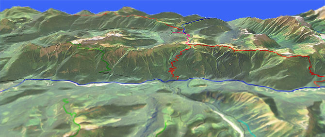
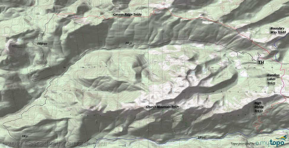
Canyon Ridge Tr689
Twitter Search
#canyonridgetrail

Overall: 6
Aerobic: 6
Technical: 5
Steepness: 5
Flow: 6
Singletrack: 100%
Three OAB trails share the Damfino Lakes TH. The Mount Baker area Canyon Ridge Tr689 heads West, Point 5658 (Boundary Way) Tr688 is a northern ridgeline ride, and High Divide Tr630 is a ridgeline trail which heads east and connects to SR542 through some steep switchbacks.
Type
OAB
Length
18mi
Ascent
Moderate
Elevation Change
TH:4200'
Avg Ascent:7000'
Ascent Incline
10%
Duration
Avg: 4hr
Weather
Forecast
NOAA
popup
USFS
Although FR3140 accesses the western Canyon Ridge Tr689 TH, that area was heavily logged and may still not be accessible.
Regardless of FR3140 access issues, due to the ride profile it's easier to ride the trail from the eastern TH.
Canyon Ridge Tr689 is usually clear of snow by July, and is part of the Canyon Creek Sno-Park for winter use.
Boundary Way Tr688 is a 7mi ridgeline OAB, with 2400' ascent over a 11% grade.
The 14mi Damfino Lakes Tr625 to High Divide Tr630 OAB has 4100' ascent over a 10% grade.
Mt Baker XC Skiing: Aside from the Salmon Ridge Sno Park, the Mt Baker Lodge area trails offer a wide variety of XC Ski terrain, from the moderate Chain Lakes Tr682 to the extreme Ptarmigan Ridge Tr682.1, for a serious backcountry winter experience.
Directions: I-5N to SR542 (Sunset Dr. / Mt. Baker Hwy), then go 35mi to Glacier. Go 2mi, past the Douglas Fir CG, then .5mi after crossing the Canyon Creek bridge, take the second left onto FR31 (Canyon Creek Rd.). Go 7.3mi to FR3140 (western TH access) or continue on FR31 another 8mi to the eastern (Damfino Lakes) TH. View Larger Map. No Map?.

OAB Directions
canyon ridge
- TH: Ascend Damfino Lakes Tr625 at the clearcut, towards Damfino Lakes, with a steep ascent through mature forest.
- .6mi: Go left onto Point 5658 (Boundary Way) Tr688.
- 1mi: Go left onto Canyon Ridge Tr689 as the ascent levels off into a rugged ridgeline ride. Climb steadily to the first of several ride summits, at 2.7mi, descend, then climb to the next peak at 3.8mi.
- 5mi: The trail appears to end in a small meadow. Go to the right following surveyor's tape and rock cairns.
- 5.2mi: At the ride summit, go through the meadow, following surveyor's tape and rock cairns. The ridgeline beyond this point is less defined, resulting in a steep descent to FR3140.
- 7.1mi: Continuing from this point adds 1000' of climbing and this area was heavily logged a few years ago and so may still not be rideable.
Nearby hiking: Church Mountain Tr671 is a forest ascent to high alpine meadows and a former lookout site, a good early season (July) hike due to southern exposure. Campers are encouraged to use a stove rather than building a fire and to help protect the vegetation by using the existing camp sites along the trail.
From the Artist Point TH, Chain Lakes Tr682 combines with Wild Goose Tr684.3 to create a challenging 6.2mi (2000' ascent) XC Ski loop, skirting the lava walls of Table Mountain, passing Iceberg and Bagley Lakes, returning in a steep 900' ascent past Heather Meadows
Nooksack Wilderness Hiking: North of SR542, this section of wilderness trails extends to Ross Lake (Whatcom Cable Crossing Trail extends to the Little Beaver trails).
Tomyhoi Lake Tr686 was built in the early 1900s by the Gold Run Mining Company, with switchbacks through avalanche chutes and thick brush which leads to a forested ascent to the flat-benched Coyote Flats meadow, with views of the steep-walled reddish Mount Larrabee peak. There are some camp sites at Tomyhoi Lake. Gold Run pass can hold snow well into summer, presenting some avalanche danger.
High Pass Tr676 traverses an avalanche chute beneath Winchester Mountain, then ascends through Low and High Pass, passing the old Gargett mine on the way to Mount Larrabee.
The accessible but steep Goat Mountain Tr673 switchbacks through timber and huckleberries, with views of the icy Mount Shuksan Price Lake (at the base of Price Glacier). Southern exposure usually opens this trail by July.
Nooksack Cirque Tr750 wanders alongside the North Fork of the Nooksack River to the headwaters, in a steep walled cirque at the base of Mount Shuksan. Be wary crossing the often-treacherous Ruth Creek, and avoid this trail after heavy rains or during Spring runoff. Continue past the North Cascades National Park boundary through fierce brush as far toward the cirque as backcountry skills allow.
Hannegan Pass Tr674 ascends the U-shaped glacier carved Ruth Creek valley before crossing the 5100' Hannegan Pass, providing access to the North Cascades Picket Range and Ross Lake, a common starting point for North Cascades National Park hiking adventures. Hannegan Camp spur trail is half a mile below the pass.
The Copper-Chilliwack loop is one of the most popular backcountry destinations in the park, with permits difficult to obtain during busy periods. A backcountry permit is required for all overnight stays. The Copper Ridge trail often has steep snow sections that require an ice axe for safe travel as late as July. Fires are not allowed at any of the Copper Ridge (Silesia, Egg Lake, and Copper Lake camps), Boundary and Whatcom camps. The Chilliwack River Trail has a number of camps along the old growth river valley, starting with Boundary Camp.
Trail Index
This Ride
Canyon Ridge Trail 689, Damfino Lakes Trail 625, High Divide Trail 630, Point 5658 Boundary Way Trail 688
Wilderness
Artist Ridge Trail 669, Chilliwack North Trail, Church Mountain Trail 671, Copper Ridge Trail, Goat Mountain Trail 673, Hannegan Pass Trail 674, High Pass Trail 676, Lone Jack Trail 675, Nooksack Cirque Trail 750, Panorama Dome Trail 684.41, Red Mountain Mine, Silesia Creek Trail 672.1, Tomyhoi Lake Trail 686, Tomyhoi Peak Trail 686.2, Twin Lakes Trail 685, Whatcom Cable Crossing Trail, Winchester Mountain Trail 685, Wells Creek Trail 682.2, Yellow Aster Butte Trail 686.1
XC Ski
Chain Lakes Trail 682, Lake Ann Trail 600, Ptarmigan Ridge Trail 682.1, Table Mountain Trail 681, Wild Goose Trail 684.3
Campgrounds
Douglas Fir Campground, Shuksan Campground, Silver Fir Campground
Trail Rankings
Ranking consistently applied to all of the listed trails.
- Overall Rating: Ride quality and challenge
- Aerobic: Ascent challenge
- Technical Difficulty: Terrain challenge
- Steepness: Average incline
- Flow: Uninterrupted riding
- Elevation Change: Total elevation gain
- Ride Difficulty: Terrain challenge


