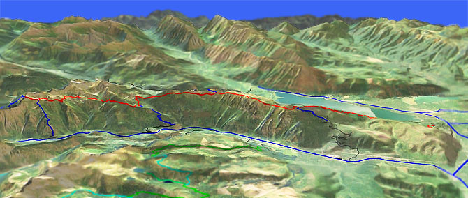
Nason Ridge Tr1583
Twitter Search
#NasonRidgeTrail

Overall: 7
Aerobic: 8
Technical: 6
Steepness: 7
Flow: 5
Singletrack: 100%
The Lake Wenatchee Washington Nason Ridge Trail can be ridden as a large loop with FR67 and Snowy Creek Tr1531, but the 16.7mi trail becomes progressively steeper in the last 5mi, so the usual ride is an OAB to Merritt Lake Tr1588.
Type
OAB
Length
Avg: 25.5mi
Ascent
Intense
Elevation Change
TH:1950'
Avg Ascent:8500'
Ascent Incline
11%
Duration
Avg: 7hr
Weather
Forecast
NOAA
popup
USFS
Trail
Review
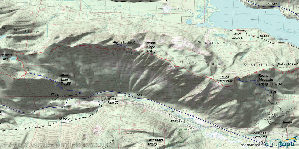
Round Mountain, Merritt Lake and Rock Mountain define the three progressively intense ride options.
The most common and easily accessible ride is the 12.5mi (3400', 11% grade) relentlessly ascending OAB from the Nason Creek campground to Round Mountain.
This can be extended by riding 3mi to Alpine Lookout, beyond which the trail descends to the Merritt Lake Tr1588 intersection.
The best ride option is to shuttle from FR6910 to Merritt Lake Tr1588, although this 10mi (3700' ascent) ride does include a 1.4mi, 1300' (17%) Round Mountain Tr1529 ascent from FR6910 to Nason Ridge Tr1583 which many riders would have to hike-a-bike.
The 4.5mi FR6910 ascends a climbable 1850', so the Nason Creek Rest Area could be used for a 22mi CCW loop, returning 6mi downhill on SR2 from Merritt Lake Tr1588.
The Merritt Lake Tr1588 TH would also be a good option for a 15mi (5900' ascent) shuttle ride from the Nason Creek campground.
The toughest options are better suited for hiking, using Snowy Creek Tr1531 to access Nason Ridge Tr1583, or Rock Mountain Tr1587 to loop with Merritt Lake Tr1588.
Since these trails get far less use, they can become overgrown and poorly maintained, so expect some pathfinding and hike-a-bike if exploring the Rock Mountain end of Nason Ridge.
Many good camping options near Lake Wenatchee, including Glacier View, Nason Creek and White Pine.
Directions: NW Forest Pass required right at the TH. There are multiple trailheads: the one shown, Chiwawa Creek and FR67, via Snowy Cr Tr1561. The most commonly used TH: SR207 to Lake Wenatchee/Fish Lake Recreation Area. Go 3.6mi and turn left on Cedar Brae Rd (to Nason Cr CG). Go .4mi then bear left, following the signs to Kahler Glen. Go .3mi and turn left to Kahler Glen. Go .2mi and bear right at the fork to the Kahler Glen Convention Center, then go to the Nason Rdg TH. View Larger Map. No Map?.

OAB Directions
many lakes
- TH: Ride through the Lake Wenatchee flats, then begin the Round Mountain ascent.
- 2.6mi: Pass a 5-way intersection, bearing to the right on some doubletrack. Crest a knoll at 3.2mi, after which the abandoned road turns into a trail again, switchbacking up the ridgeline to a 4.9mi crest.
- 6.3mi: After some more switchbacks, crest a knoll and pass the Round Mountain Tr1529 intersection on the left (a common turnaround point), then hike-a-bike for .2mi before riding around Round Mountain.
- 7.3mi: Descend to a saddle then ascend to the 8.4mi ride summit.
- 9.3mi: Consider turning around at the Alpine Lookout intersection (aka Nine Mile Saddle). The off-ridgeline traversing descent to Merritt Lake is fun but will require some hard climbing to get back to Nine Mile Saddle.
- 12.8mi: Turnaround at the Merritt Lake Tr1588 intersection, or descend 2mi to SR2 and ride downhill back to SR207 and on to the Nason Creek CG TH.
Trail Index
This Ride
Merritt Lake Trail 1588, Nason Ridge Trail 1583, Rock Mountain Trail 1587, Round Mountain Trail 1529, Snowy Creek Trail 1531
Wilderness
Campgrounds
Glacier View Campground, Nason Creek Campground, Riverside Campground, White Pine Campground
Trail Rankings
Ranking consistently applied to all of the listed trails.
- Overall Rating: Ride quality and challenge
- Aerobic: Ascent challenge
- Technical Difficulty: Terrain challenge
- Steepness: Average incline
- Flow: Uninterrupted riding
- Elevation Change: Total elevation gain
- Ride Difficulty: Terrain challenge


