Twitter Search
#PacificCrestTrail
Mount Thielsen Mountain Biking and Hiking Topo Map
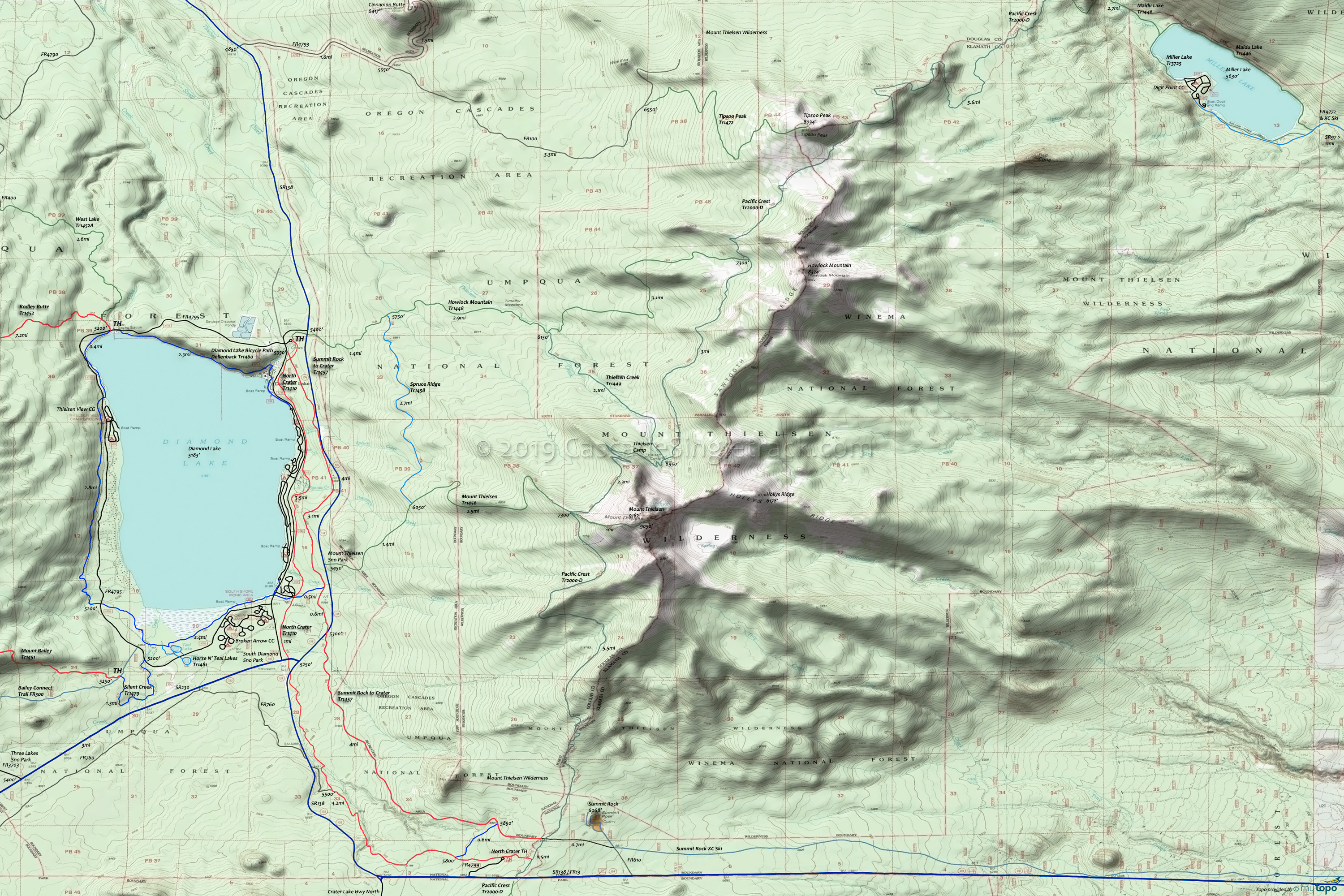
Map includes: Diamond Lake Bicycle Path Trail 1460, Howlock Mountain Trail 1448, Maidu Lake Trail 1446, Miller Lake Trail 3725, Mount Thielsen Trail 1456, North Crater Trail 1410, Pacific Crest Trail 2000-D, Spruce Ridge Trail 1458, Summit Rock to Crater Trail 1457, Thielsen Creek Trail 1449, Tipsoo Peak Trail 1472 Mountain Biking and Hiking Trails.
TH: Ride lakeside on North Crater Trail 1410 past Diamond Lake CG area, just uphill of FR4795 and crossing FR051 at 3.5mi.
4.2mi: Cross SR230 then SR138 near the intersection of those two roads. Ascend 500ft over the next 3mi, passing a road at 6mi and a trail at 7.4mi.
8mi: Go left on the connector to Summit Rock to Crater Trail 1457, the 5860' ride summit.
8.5mi: Go left on Summit Rock to Crater Trail 1457 and descend 3.5mi to SR138.
12mi: Cross SR138 and traverse the lakeside hill back to the TH.
Mount Thielsen Wilderness
The Howlock and Mount Thielsen TH both serve hikers and nordic skiers on the western flank of Mount Thielsen, progressing through lodgepole pine to mountain hemlock and fir.
Spruce Ridge Tr1458, the creekside Thielsen Creek Tr1449 and Pacific Crest Trail 2000-D connect the two primary ascent routes. Thielsen Camp is at the intersection of Thielsen Creek Tr1449 and Pacific Crest Trail 2000-D.
Mount Thielsen Tr1456 conitinues past Pacific Crest Trail 2000-D, with a Class 5 scramble to the to the spire-pointed peak of Mount Thielsen. Warning: due to exposure there have been more fatalities on this route than have occurred on all the technical routes on the Umpqua National Forest combined.
Howlock Mountain Tr1448 passes Timothy Meadow just prior to the Thielsen Creek Tr1449 intersection, with a slightly steeper ascent to Pacific Crest Trail 2000-D.
Tipsoo Peak Tr1472 is a series of wide switchbacks traversing through a widely spaced mountain hemlock and true-fir forest, with little ground vegetation. The last mile has open dry meadows. The final 500 feet is a scramble along a narrow rocky ridge. Pacific Crest Trail 2000-D is a further 0.3mi unmarked scramble down the eastern slope of Tipsoo Peak.
Maidu Lake Tr1446 and Miller Lake Tr3725 are accessed from SR97 via SR138/FR13 and FR9772. Not shown on the map, Maidu Lake Tr1446 crosses Pacific Crest Trail 2000-D to Maidu Lake and Lake Lucile Tr1459 (Umpqua River headwaters).
This is a remote area, so verify with the forest service that the trails are accessible prior to visiting.
Be prepared for hoards of mosquitos during the late spring and early summer months.
Draggable map: Map window adjusts to screen size and will respond to touch control. Use scrollbar for mouse control.
No Map? Browser settings and some browser extensions can prevent the maps from appearing. Please see Site Tech


