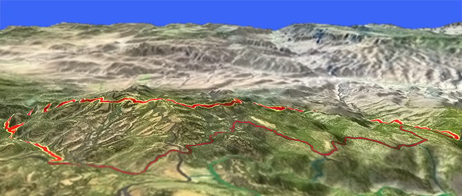
Ochoco Mountain Trail 823
Twitter Search
#Ochocos

Overall: 6
Aerobic: 6
Technical: 6
Steepness: 6
Flow: 5
Singletrack: 90%
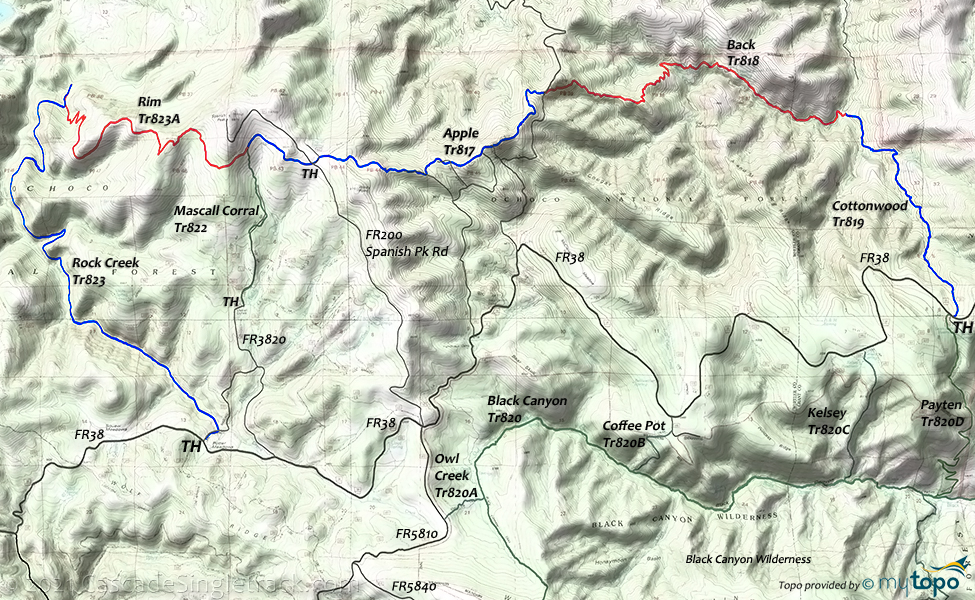
The Dayville Oregon Ochoco Mountain Trail is a combination of these former trail segments (listed West to East): Rock Creek Tr823, Rim Tr823A, Apple Tr817, Back Tr818, Cottonwood Tr819, with Mascall Corral Tr822 as a connector.
Type
Loop
Length
Avg: 16mi
Ascent
Intense
Elevation Change
TH:5500'
Avg Ascent:3400'
Ascent Incline
9%
Duration
Avg: 3hr
Weather
Forecast
NOAA
popup
USFS
The full 38mi CCW (7600' ascent) CCW loop would include 14.2mi (1500' ascent) on FR38 and a 10% descent to and from Cottonwood Creek, so is best managed with a shuttle and strong climbing skills.
Expect less traffic on Apple Tr817, Back Tr818, Cottonwood Tr819 and check trail conditions with the local ranger station before attempting that backcountry route.
A less epic 24mi (4900' ascent) CCW loop route starts with 8.6mi (1600' ascent) of FR38 and FR3850 to the Apple Tr817 TH, returning on Rim Tr823A and Rock Creek Tr823.
Note: FR3850 and FR200 are primitive jeep roads, which may not be passable in wet conditions.
Rock Creek Tr823 is a hillside trail which ascends (5% grade) the rock creek drainage (alongside the E.O.Waterman mining ditch for the first few miles) between willow and alder thickets, dense lodgepole pine forest, and open ponderosa pine slopes to Potter Meadows. The trail includes some technically challenging hillside exposure combined with narrow trail surface.
Rim Tr823A descends from the grassy open slopes on the west flanks of Spanish Peak through dense mixed conifer forest to the First Creek drainage.
Mascall Corral Tr822 ascends from a historic sheep handling pen to the southern flank of Spanish Peak, intersecting with Apple Tr817 and Rim Tr823A.
The primitive Apple Tr817 parallels ridge routes followed by the historic Mascall Stock Driveway and the Paulina-Dayville Wagon Road (Apple Road) through open grass and shrubland, and mixed conifer forest.
Back Tr818 ascends through dense mixed conifer forest from the Cottonwood Creek drainage along ridge systems parallel to Back Creek through open ponderosa pine forest and mahogany thickets. After crossing Back Creek, the trail switchbacks to the Apple Tr817 FR3850 TH.
The primitive Cottonwood Tr819 crosses then descends (10% grade) the East Fork of Cottonwood Creek, passing through dense mixed conifer forest with scattered ponderosa pine and grassy openings.
Directions: See Map. From Prineville, the TH is about 2.5hrs (80mi) from Prineville, on US26/FR12 or SR380 through Paulina. From Paulina, go east on SR380 (Paulina-Suplee Hwy) for 3.5mi to FR58 (Beaver Creek Rd), then go 7.5mi to FR42. Go on FR42 1.5mi to FR3810 then go 6.5mi to FR38 (or continue on FR42 to FR38). Go east on FR38 3.5mi to the Rock Creek TH at Potter Meadow. View Larger Map. No Map?.

Loop Directions
spanish peak loop
Ochoco Mountain Trail Area Topo Map
- TH: Ride .9mi to FR3820, then ascend FR3820 2mi (500') to the Mascall Corrals TH.
- 3mi: Ascend Mascall Corral Tr822 2mi (800' ascent) to the Rim Tr823A TH on the southern flank of Spanish Peak.
- 5mi: Continue the ascent on Rim Tr823A, to the ride summit at 5.3mi, then descend 2000' through several grassy sloped drainages to the dense forest alongside First creek.
- 9.6mi: Go onto Rock Creek Tr823 and cross First creek, then ride alongside the E.O.Waterman mining ditch, crossing Second creek and Fir Tree creek drainages.
- 14mi: Short descent to Rock creek, followed by a steeper creekside ascent through willow and alder thickets to the TH.
Black Canyon Wilderness Hiking
Shown on the Ochoco Mountain Trail Area Topo Map, the Black Canyon wilderness descends from near the summit of Wolf Mountain to the South Fork of the John Day River, through open ponderosa pine forest, dense mixed conifer forest, small meadows, shrubby streamsides and open grassy slopes, ending in a narrow basalt cliff canyon.
Black Canyon Tr820 parallels Owl Creek and Black Canyon Creek, terminating at the South Fork John Day River Rd (a good day-hike TH). The first three miles includes a number of wet Black Canyon Creek crossings, making this a hazardous trail during the Spring melt.
Owl Creek Tr820A (previously Boeing Field Trail) provides easier access to Black Canyon Tr820 in the Spring and Fall, and avoids travelling on the rough FR5840 to the Dusty Camp TH near Wolf Mtn.
Payten Tr820D was damaged in the 2002 '747' fire and may not be passable. This trail previously crossed private land, with that access prohibited. Check with the local ranger station or for TH signage prior to use.
Coffee Pot Tr820B and Kelsey Tr820C are very steep unmaintained trails which follow ridges and cross open slopes through grassy ponderosa pine forest with impressive views of Black Canyon Wilderness. Check with the local ranger station or for TH signage prior to use.
From the Mud Springs CG, South Prong Tr821 (damaged in the 2002 '747' fire) descends through mixed conifer and ponderosa pine forest on high terrain to a fenceline just east of Crowbar Spring, then descends 2mi (1600' descent) through dense mixed conifer forest to the bottom of Black Canyon.
Not shown on the map, but Pine Tree CG is on South Fork John Day River Rd, just north of the Black Canyon Tr820 TH.
Be prepared for close encounters with rattlesnakes, black bear and mountain lions.
Trail Index
Ochoco Mtn Trail 823 segments
Apple Trail 817, Back Trail 818, Cottonwood Trail 819, Rim Trail 823A, Rock Creek Trail 823
Area
Mascall Corral Trail 822
Black Canyon Wilderness
Black Canyon Trail 820, Coffee Pot Trail 820B, Kelsey Trail 820C, Owl Creek Trail 820A, Payten Trail 820D, South Prong Trail 821
Campgrounds
Cottonwood Campground (FR12), Sugar Creek Campground (FR58), Mud Springs Campground (FR5840), Wolf Creek Campground (FR42)
Trail Rankings
Ranking consistently applied to all of the listed trails.
- Overall Rating: Ride quality and challenge
- Aerobic: Ascent challenge
- Technical Difficulty: Terrain challenge
- Steepness: Average incline
- Flow: Uninterrupted riding
- Elevation Change: Total elevation gain
- Ride Difficulty: Terrain challenge


