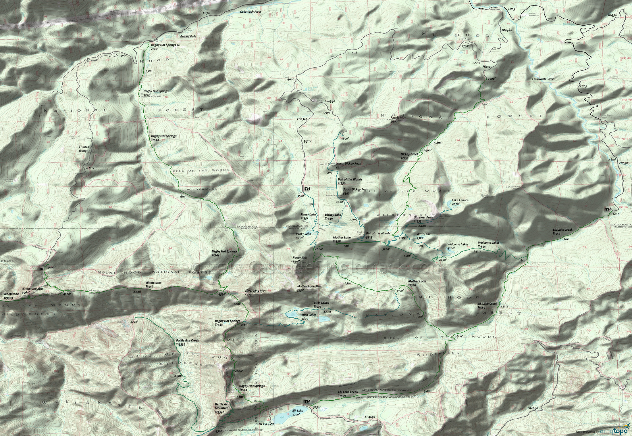
Bull-of-the-Woods Wilderness Hiking Topo Map
Dickey Creek Tr553 provides the earliest access to the Bull of the Woods Wilderness and a direct route to the popular Big Slide Lake, passing through deep forest in the Dickey Creek drainage for the first three miles, then ascending to the ridge above Big Slide Lake.
Shreiner Peak Tr555 is a great hike to the small alpine Lake Lenore, with views of the surrounding peaks and Welcome Lakes while passing through several meadows. From Welcome Lakes Tr554, the trail descends a steep north-facing slope for .6mi to the junction with Dickey Creek Tr553. Shreiner Peak Tr555 descends steeply off the Big Slide Mountain saddle and enters a large burn area before reaching Lake Lenore.
Welcome Lakes Tr554 is the major east-west connector between the Bull of the Woods summit and Elk Lake Creek Tr559, traversing a range of terrain from deep old growth to open rocky ridges and intersecting with many of the other trails.
Elk Lake Creek Tr559 follows Elk lake Creek through very large Douglas and True Fir old growth forest, June rhododendrons and waterfalls, to the Welcome Lakes Tr554 intersection, then continues the ascent to Elk Lake. The hike involves several creek crossings, notably at Pine Cone and Knob Rock creeks, and Elk Lake creek as well (a dangerous high water crossing).
Mother Lode Tr558 passes through old growth Douglas Fir, True Fir and Mountain Hemlock with views of Mount Jefferson, with several creek crossings along the way.
Bull of the Woods Tr550 is a popular day hike, traversing the west slopes of North and South Dickey Peaks, offering views of Mount Hood, Three Sisters, Mount Jefferson and Three Fingered Jack. Visit the fire lookout at the south end of the trail for more views of the surrounding area.
The popular Pansy Lake Tr551 ascends 1,000’ in 2mi to the ridge top beyond the lake. From Pansy Lake, the trail ascends steep, rocky terrain .7mi to the Mother Lode Tr558 intersection.
Twin Lakes Tr573 is the most popular trail, as an easy access loop connector. Note: FR4697 is a rough jeep trail.
Bagby Hot Springs Tr544 follows Hot Springs Fork of the Collowash River and passes through old growth trees to the open-air tubs at Bagby Hot Springs, continuing south 5.6mi, crossing 14 streams before reaching a spur trail intersection (to Silver King Lake). Bagby Hot Springs Tr544 then switchbacks 1mi to the ridge and Whetstone Tr546 intersection. Whetstone Tr546 becomes Whetstone Tr3369 in the Willamette NF and continues past Wildcat Swamp and into the Horse Lake area.
Draggable map: Map window adjusts to screen size and will respond to touch control. Use scrollbar for mouse control.
No Map? Browser settings and some browser extensions can prevent the maps from appearing. Please see Site Tech


