Smith Creek Tr225

Overall: 10
Aerobic: 7
Technical: 9
Steepness: 8
Flow: 7
Singletrack: 100%
There are no non-epic Smith Creek Tr225 ride options. If CW doesn't seem epic enough, try it CCW. The trail traverses the blast zone, so expect pumice, rocks and washouts.
Type
Loop
Length
Avg: 22mi
Ascent
Mt Goat
Elevation Change
TH:2800'
Avg Ascent:6300'
Ascent Incline
14%
Duration
Avg: 6hr
Weather
Forecast
NOAA
popup
USFS
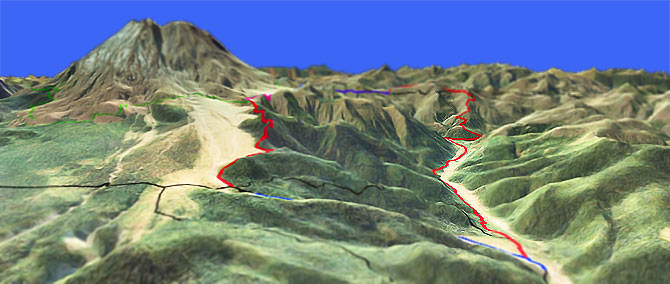
The 3mi, 14% Smith Creek switchbacking drainage descent is steep, rocky and rarely maintained.
Then the ride gets interesting, with various combinations of unstable creekside washouts, cliff exposure and river crossings.
Two waterfalls are located near the base of the steep descent.
Following the valley bottom, the trail crosses Ape Canyon Creek and then crosses the Muddy River.
The trail can become overgrown in late summer, increasing the pathfinding nature of this ride.
An indication of how technical the Smith Creek Tr225 descent is, the ride is ranked as Mt Goat even though it relies on the relatively easy Ape Canyon Tr234 ascent.
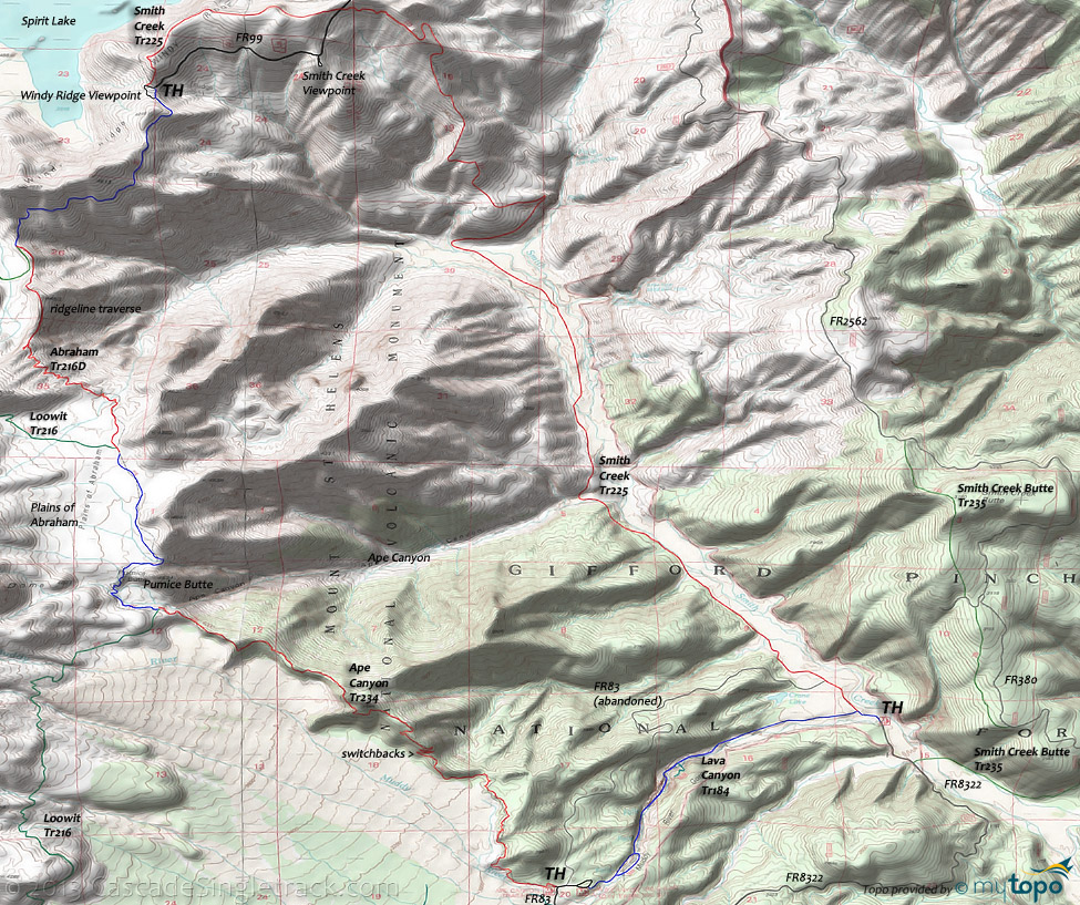
Although a north-south shuttle is impractical, due to the driving distance, the 4.8mi FR8322 can provide an alternative to the 2.6mi, 1300' Lava Canyon Tr184 ascent, by shuttling between the lower Smith Creek Tr225 TH and the Ape Canyon Tr234 TH.
Another alternative to climbing Lava Canyon Tr184 is to climb the abandoned portion of FR83, shown on the map.
Upper Lava Canyon Tr184 includes a side loop with a 125ft cable suspension bridge canyon crossing.
The lower trail descends into the canyon, with cliff exposure followed by a water crossing with a cable grab-line.
The trail then widens out as it approaches the Smith Creek valley and the intersection with Smith Creek Tr225.
The trail offers some interesting views of lava formation, with a 30ft metal ladder vertical cliff descent providing access to the canyons deepest recesses and roaring waterfalls.
Ship Tr184B climbs 0.2mi to a viewpoint atop the Ship, a lava formation that overlooks a series of canyon waterfalls.
Mosquitoes are ferocious in this area until August. Feel free to try the natural repellents, and avoid drinking carbonated drinks prior to riding, but Deet 100 may be the only protection from 'the swarm'.
Directions: NW Forest Pass required right at the TH. From Cougar, SR503E becomes Lewis River Road then FR90. Go left on FR83 then go 11mi to the TH. FR8322 leads to the lower Smith Cr TH. View Larger Map. No Map?.

Loop Directions
vertical descent
- TH: The Ape Canyon portion of the ride starts with a .5mi rooty section alongside the usually dry Muddy River drainage, followed by the first great view of St Helens and 1mi of undulating trail.
- 1.5mi: Enter the switchback section, with a 1.5mi, 14% climb through 5 switchbacks, followed by a brief descent then a more gradual 1.5mi climb to the top.
- 4.6mi: Reach Butt Crack, formed by the lahar flow to Ape Canyon during the eruption. This is the beginning of the Loowit Tr216 section, which starts with a very narrow, cliff exposure section which often needs to be walked. This portion of the trail is undercut by erosion and at times can be quite dangerous. If you fall, you won't be doing anything else for the rest of the day...or maybe ever.
- 5.3mi: After traversing several drainages, Loowit Tr216 reaches the top of a waterfall, with a great view of Smith Creek and Mount Adams. The drainages can have significant flow from Spring till July and should be very carefully crossed if still snow packed, due to the high risk of breaking through the snow and becoming trapped. After the waterfall, the trail opens up onto the Plains of Abraham, with a slight grade and flat terrain.
- 6.2mi: Reach the Loowit Tr216 intersection, continuing straight onto Abraham Tr216D. Go through a drainage then a switchback ascent, followed by a descent to the Willow Springs Tr207 staircase and ridgeline trail over to FR9900. The ridgeline section consists of a narrow trail with moderate slope on each side, which tends to get the attention of most riders.
- 10.2mi: At FR9900, go left onto Smith Creek Tr225, on the north side of Windy Ridge, crossing FR9900 again at 11.7mi. Go out the ridge then begin 3mi switchback descent, being careful not to lose the barely marked trail, or simply losing it.
- 14.8mi: Reach Smith Creek and several stream crossings, to the west side of the channel.
- 17.2mi: Cross Ape Canyon Creek. Keep track of the trail location on the other side of the creek before crossing, as it is easy to miss. Additional stream crossings at 18.1mi and 18.8mi. Note the jeep track which parallels the trail, and leads to FR83 and FR8320.
- 19.3mi: Reach an abandoned portion of FR83, an alternative to climbing Lava Canyon Tr184 or FR8320. Go right when the trail reaches the wide, overgrown road. The intersection is marked with a rock cairn and a stick, where FR83 intersects with the creekside jeep track. FR83 barely exists at first, like riding across a grassy field, but becomes distinct as it reaches the treeline. This abandoned portion of FR83 has 3.2mi of undulating terrain, with a 1600' ascent and an 11% grade over the first 2mi.
- 19.6mi: The second climb option is Lava Canyon Tr184, described above and much steeper than climbing FR83. The first 1mi is a nearly unclimbable 15% grade.
- 19.8mi: Reach FR8320, the longest ascent option. The first 1.5mi is a 15% grade.
Trail Index
This Ride
Abraham Trail 216D, Ape Canyon Trail 234, Lava Canyon Trail 184, Smith Creek Trail 225
Area
Wilderness
Independence Pass Trail 227, Loowit Trail 216, Pine Creek Tr216C, Ship Trail 184B, Smith Creek Butte Trail 235, Willow Springs Trail 207, Windy Tr216E
XC Ski
Kalama Ski Trail 231, Sasquatch Ski Loops Trail 236, Swift Ski Trail 244, Wapiti Ski Loops Trail 245, West Fork Snowmobile Trail 243
Campgrounds
Trail Rankings
Ranking consistently applied to all of the listed trails.
- Overall Rating: Ride quality and challenge
- Aerobic: Ascent challenge
- Technical Difficulty: Terrain challenge
- Steepness: Average incline
- Flow: Uninterrupted riding
- Elevation Change: Total elevation gain
- Ride Difficulty: Terrain challenge


