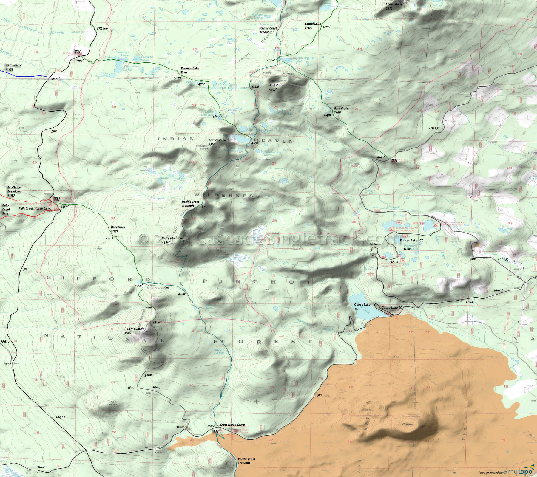
Indian Heaven Wilderness and Pacific Crest Trail Hiking Topo Map
Twitter Search
#PacificCrestTrail
Map includes: East Crater Trail 48, Indian Racetrack Trail 171, Lemei Lake Trail 179, Pacific Crest Trail 2000H, Thomas Lake Trail 111 and Tombstone Lake Trail 55.
The 20,782 acre Indian Heaven Wilderness is a forested high plateau, dominated by fir (Pacific silver, noble, subalpine), with numerous open meadows and more than 150 lakes. Many of the lakes are stocked with rainbow and brook trout.
Lava once flowed from the numerous volcanic cones that rise above the plateau which reach their highest point on Lemei Rock (5927'), where a broad crater now contains Lake Wapiki.
Originally known as 'Sahalee Tyee', the area is culturally important to Native Americans. Over the past 9,000 years the Yakima, Klickitat, Cascades, Wasco, Wishram, and Umatilla tribes gathered here for berry picking, fishing, and hunting. Indian Racetrack is named after a 2000' long field where horse racing once provided a break from the tribal food-gathering routine.
Fall is a good time to visit due to the brilliant fall colors and the winding down of mosquito season.
Watch for native summertime deer and elk populations, along with black bears during the fall huckleberry season.
No camping allowed within 100 feet of the Pacific Crest Trail or within 100 feet of lakes, with exceptions at designated Thomas and Blue Lake campsites.
Tombstone Lake Trail 55 is a .5mi trail from the Pacific Crest National Scenic Trail 2000 (near the east shore of Blue Lake) to Tombstone Lake. The lake and trail are named for the rock jutting out of the small lake.
Thomas Lake Tr111 is a heavily-used trail ascends to a meadow, then continues past Brader Lake and Naha Lake to Rock Lake and Little Rock Lake before heading south past Lake Umtux. Pass through the broad plateau meadow by numerous unnamed ponds and tiny lakes. Descend into timber, passing Lake Sahalee Tyee, ending at Blue Lake with the junction of the Pacific Crest Trail.
Lake Sahalee Tyee lies in the shallow crater of an old volcano, where Native Americans built slow-burning fires in trenches, preserving berries for later use by drying them over the radiant heat.
Draggable map: Map window adjusts to screen size and will respond to touch control. Use scrollbar for mouse control.
No Map? Browser settings and some browser extensions can prevent the maps from appearing. Please see Site Tech


