Huxley Lake to Grouse Point Tr517
Twitter Search
#RoaringRivers

Overall: 7
Aerobic: 9
Technical: 7
Steepness: 9
Flow: 5
Singletrack: 100%
The Clackamas Oregon Huxley Lake to Grouse Point Trail is part of the Roaring Rivers Wilderness and so closed to biking. Those seeking a moderate area ridgeline ride might check out Rhododendron Rdg Tr564.
Type
OAB
Length
Avg: 26mi
Ascent
Mt Goat
Elevation Change
TH:4000'
Avg Ascent:9200'
Ascent Incline
25%
Duration
Avg: 8hr
Weather
Forecast
NOAA
popup
USFS
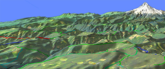
Crossing the Roaring river drainage makes the OAB Grouse Point Tr517 hike quite challenging, with about a 5000' gain/loss. The Mt Goat reputation of this trail is due to the 2mi, 2600' Roaring river drainage ascent to the Dry Ridge Tr518 intersection, a virtually unclimbable 25% grade over some very tight switchbacks. The Roaring river can be impassable until July, depending on snow pack and rainfall, and as an OAB, this too-steep terrain must be covered coming and going.
Anyone willing to tackle the Roaring river drainage may also want to include a Serene Lake Tr512 CW Loli, so that is included in the ride description below.
Due to the extreme vertical and lack of additional nearby trails, Grouse Point Tr517 doesn't get much use and so may be in poor condition well into the hiking season.
Be sure to ask the forest service about trail conditions prior to tackling this one and be ready to deal with some treefall.
As a shuttle ride or an OAB from the Hideaway Lake campground, the ascent is merely intense.
Cripple Creek Tr703 ascends 2650' in 2.7mi over two 20% stages.
SR224 shuttle option: Dry Ridge Tr518 descends 3300' in 6mi, through a series of tight switchbacks over an overall 10% grade, and would be a good trail to use for a shuttle hike from the Hideaway Lake campground. Dry Ridge Tr518 passes through areas of old growth trees, dogwood, and white iris to a view of the Clackamas canyon.
Serene Lake Tr512 can be combined with Grouse Point Tr517 to form a CW loop without adding any length to the hike.
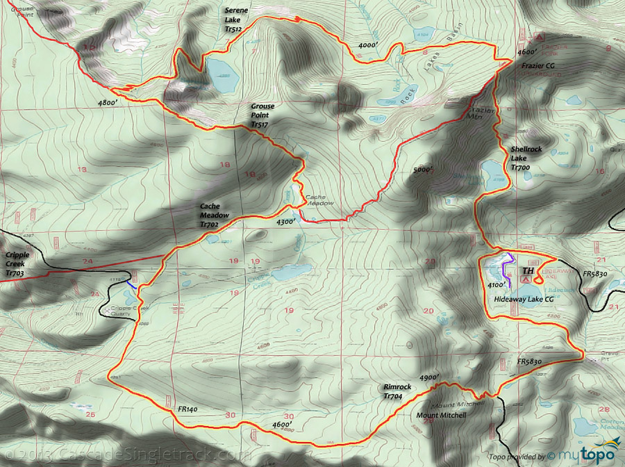
Described below, an intense 16mi (3600' ascent, 7% grade) Mount Mitchell to Frazier Mountain CW loop consists of Rimrock Tr704, Cache Meadow Tr702, Grouse Point Tr517, Serene Lake Tr512 and Shellrock Lake Tr700. Cache Meadow Tr702 passes through mature sub-alpine timber and passes two meadows and two seasonal lakes before ending at Cache Meadows.
There are a number of good camping sites in the area. The Frazier Turnaround or Hideaway Lake campground would make a good base-camp, with reasonable access to other trails in the area.
Rimrock to Serene Lake CW Loop
TH: From the Hideaway Lake campground, go left on FR5830 and gradually ascend to the Rimrock Tr704 intersection.
2.6mi: Go left onto Rimrock Tr704 and hike the switchback ascent of Mount Mitchell, reaching the summit at 3.4mi. Descend just as steeply until the trail merges with FR140 at 4.5mi.
6.1mi: go right onto Cache Meadow Tr702 just before reaching the Cripple Creek quarry, then cross Cripple creek. Pass a small lake at 7mi.
7.7mi: Go left on Grouse Point Tr517 and hike through .9mi of switchbacks to the second summit, then descend to the Serene Lake Tr512 intersection.
9.6mi: Go right onto Serene Lake Tr512 and continue the uneven descent, passing Serene Lake at 10.6mi then riding around a ridgeline before crossing a tributary of the South Fork Roaring river at 12.3mi. Near a small lake in the Rock Lakes Basin, go right at a T intersection, then go left at the next T intersection, while ascending to the Frazier Turnaround campground.
13.3mi: Go right onto Grouse Point Tr517 at the Frazier Turnaround campground, ride .2mi then go left onto Shellrock Lake Tr700 and descend to the Hideaway Lake campground.
From the Indian Henry CG TH, Clackamas River Tr715 passes through old growth forest with some views of the Clackamas River and the 100' Pup Creek Falls along the way to the Fish Creek CG TH.
Directions: See Map. OAB:I-205 to SR224E to FR4610 to Lookout Springs CG. View Larger Map. No Map?.

OAB Directions
roaring river madness
The typical Huxley Lake to Grouse Point 26mi (9200' ascent) OAB, for those seeking big vertical hill ascent.
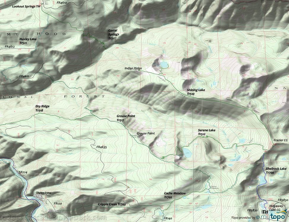
- TH:From the Lookout Springs CG, go .41mi on Corral Springs Tr507 to Huxley Lake Tr521, then go right and pass Huxley Lake at 2.1mi.
- 3.1mi: Go left onto FR4611 at the T intersection. Just past a Huxley Lake creek crossing, go right onto Grouse Point Tr517 at the 3.9mi T intersection, then descend to Roaring river.
- 4.6mi: After a 1mi (800') switchbacking descent, ascend 2mi (2500') to the Dry Ridge Tr518 intersection, crossing a tributary of the South Fork Roaring river at 5.3mi.
- 6.8mi: After recovering from the Roaring river drainage exodus, pass the Dry Ridge Tr518 intersection on the right then continue ascending at a more reasonable rate to the Serene Lake Tr512 intersection, passing Grouse Point at 8mi.
- 9mi: Go left onto Serene Lake Tr512 and descend through some switchbacks to Serene Lake at 10.1mi. Descend around a ridge flank then cross the South Fork Roaring river at 11.7mi. Near a small lake in the Rock Lakes Basin, go right at a T intersection, then go left at the next T intersection, while ascending to the Frazier Turnaround campground.
- 12.8mi: Go right onto Grouse Point Tr517 at the Frazier Turnaround campground, pass the Shellrock Lake Tr700 intersection on the left, then reach the Frazier Mountain summit at 13.3mi.
- 14.9mi: Descend through some switchbacks to the Cache Meadow Tr702 intersection, cross Cripple creek, then continue ascending to the ridgetop. Pass Serene Lake Tr512 intersection at 16.8mi. Return to the TH.
Trail Index
This Hike
Cache Meadow Trail 702, Corral Springs Trail 507, Cripple Creek Trail 703, Dry Ridge Trail 518, Grouse Point Trail 517, Huxley Lake Trail 521, Serene Lake Trail 512, Shellrock Lake Trail 700
Area Rides
Alpine Trail 600, Crosstown Trail 755, Dog River Trail 675, East Fork Trail 650, Fanton Trail 505, Glade Trail 661, Gumjuwac Trail 480, Gunsight Trail 485, Larch Mountain Trail 441, Lodgepole Trail 706, Old Baldy Trail 502, Oneonta Trail 424, Pioneer Bridal Trail 795, Pocket Creek Trail 684, Rhododendron Ridge Trail 564, Rhododendron Ridge Urban Link Tr564, Riverside National Recreation Trail 723, , Still Creek Trail 780, Surveyors Ridge Trail 688, , Zig Zag Trail 678
Roaring River Wilderness and Area Hiking
Anvil Lake Trail 724, Clackamas River Trail 715, Cottonwood Meadows Trail 705, Eagle Creek Trail 501, Eagle Creek Cutoff Trail 504, Plaza Trail 783, Rimrock Trail 704, Salmon Mountain Trail 787, Shining Lake Trail 510
Sandy Ridge Trails
Campgrounds
Alder Flat Campground, Armstrong Campground, Carter Bridge Campground, Fish Creek Campground, Frazier Campground, Hideaway Lake Campground, High Rock Spring Campground, Indian Henry Campground, Lake Harriet Campground, Rainbow Campground, Ripplebrook Campground, Roaring River Campground, Shellrock Creek Campground, Sunstrip Campground
Trail Rankings
Ranking consistently applied to all of the listed trails.
- Overall Rating: Ride quality and challenge
- Aerobic: Ascent challenge
- Technical Difficulty: Terrain challenge
- Steepness: Average incline
- Flow: Uninterrupted riding
- Elevation Change: Total elevation gain
- Ride Difficulty: Terrain challenge


