
Surveyors Ridge Tr688
Twitter Search
#surveyorsridgetrail

Overall: 10
Aerobic: 6
Technical: 5
Steepness: 4
Flow: 9
Singletrack: 100%
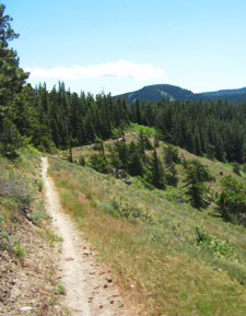
The Mount Hood Oregon Surveyors Ridge is a classic ridgeline trail, with moderate climbing that intensifies over the length of the trail, offering great views of Mt. Hood and the valley below.
44 Trails rerouted the section just past Cooks meadow, from a doubletrack to singletrack, due to water line construction work.
The total length of this ride, as an OAB between FR44 and FR17, is 34mi. The stats and guide reflects an OAB ride from FR44 to the powerline TH.
Type
OAB
Length
Avg: 27mi
Ascent
Moderate
Elevation Change
TH:4250'
Avg Ascent:4650'
Ascent Incline
4%
Duration
Avg: 4hr
Weather
Forecast
NOAA
popup
USFS

The Surveyors Ridge Tr688 TH is also the trailhead for High Prairie Tr639.
Surveyors Ridge Tr688 gets dusty in late summer, can be limited by treefall in the Spring, and dries out within a few days of rainfall.
FR17 parallels Surveyors Ridge Tr688, with several FS connectors to the trail along the way, which might be useful in case of a breakdown or accident but not recommended as a return loop.
Although most riders choose to start from FR44, using the northern FR17 TH as the starting point enables the entire trail to be ridden, without creating an inverted ride profile.
If starting from the southern FR44 TH, then either turn around at Bald Butte Mountain or shuttle to the northern TH, due to the steep descent from Bald Butte to the northern FR17 TH.

For those seeking a more strenuous ride, Surveyors Ridge Tr688 can be combined with Oak Ridge Tr688A and Dog Rvr Tr675 into an all-day, epic 27mi ride.
Start at the Oak Ridge Tr688A TH. Go on Smullin Rd, on the left 1.4mi past the Mt Hood Country Store and just before the Hwy Dept facility.
The road to the Oak Ridge TH is at the first curve.
For camping, check out Knebal Spgs CG, which is the TH for the Knebal Spgs Tr474 loop.
Dog River Surveyors Epic
This is a 24.5mi (5200' ascent) CCW loop, consisting of Dog Rvr Tr675 to Surveyors Ridge Tr688, ending with a wild bombing run on Oak Ridge Tr688A.
TH: From the Oak Ridge Tr688A TH, go to SR35 then climb 500' on SR35S to the Dog Rvr Tr675 TH.
3.7mi: Climb 6.6mi (2500' ascent) on Dog River Tr675 to FR620, then go 2.6mi further to the Surveyors Ridge Tr688 TH.
10.9mi: Ride Surveyors Ridge Tr688 to the 1850' Oak Ridge Tr688A descent back to the TH.

Directions: NW Forest Pass required right at the TH. Pass the Parkdale ranger station and continue SR35S to FR44. Go up FR44 to the Surveyors Ridge TH at FR620. Loop: Park at the Oak Ridge or Dog River TH. View Larger Map. No Map?.


OAB Directions
round the bend and into the woods
- Ride starts with singletrack alongside FR44, to the second creek crossing, a fast, relatively flat section with a few waterbar jumps along the way.
- 1.6mi: At Cooks Meadow, go straight just before the small creek (crossing the creek was the old route), then go for 3.6mi over a knoll to the FR17 intersection with Super Connector trail road. Option: use The Hub to access Super Connector.
- 5mi: After a little section of fast, winding singletrack, go around a scree field then cross FR680. After passing several view points, with some short ascents, pass Shellrock Mountain at 8.2mi.
- 9.7mi: After a short but steep ascent, descend to a FR17 intersection, just south of Gibson Prairie Horse Camp. This is followed by another steep ascent, to FR671.
- 10.6mi: Cross FR671 as the descent intensifies as the ridgeline drops off to the next FR17 TH.
- 11.2mi: Descend to Yellowjacket Creek, followed by a short climb to a view point. This is followed by a steep descent to the Oak Ridge Tr688A upper TH
- 12.7mi: From the Oak Ridge Tr688A upper TH the trail continues to drop off sharply to FR630 and the power line TH. Trail continues for 3.5mi, past Bald Butte to the northern FR17 TH.

 OAB Elevation Profile")
Trail Index
This Ride
Dog River Trail 675, Oak Ridge Trail 688A, Surveyors Ridge Trail 688
Area
Bonney Meadows Trail 471, Bottle Prairie Trail 455, Boulder Lake Trail 463, Casey Creek Trail 476, Cedar Creek Trail 457, Cooks Meadow Trail 639, East Fork Trail 650, Eightmile Creek Trail 459, Fifteenmile Trail 456, Forest Creek Trail 473, Gumjuwac Trail 480, Gunsight Trail 485, Hidden Meadows Trail 472, Horkelia Meadows Trail 20, Knebal Springs Trail 474, Lookout Mountain Trail 450, Pocket Creek Trail 684, Underhill Trail 683, Zig Zag Trail 678
Mount Hood Wilderness Hiking
Bluegrass Ridge Trail 647, Elk Meadows Trail 645, N Section Line Trail 451, Robinhood Trail 11, Tamanawas Falls Trail 650B, Tamanawas Tie Trail 650B
XC Ski
Campgrounds
Bottle Prairie Campground, Eightmile Crossing Campground, Fifteenmile Campground, Knebal Springs Campground, Pebble Ford Campground, Robinhood Campground, Sherwood Campground
Trail Rankings
Ranking consistently applied to all of the listed trails.
- Overall Rating: Ride quality and challenge
- Aerobic: Ascent challenge
- Technical Difficulty: Terrain challenge
- Steepness: Average incline
- Flow: Uninterrupted riding
- Elevation Change: Total elevation gain
- Ride Difficulty: Terrain challenge
