
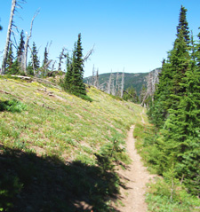
Gunsight Ridge Tr485 to Gumjuwac Tr480
Twitter Search
#GunsightTrail

Overall: 6
Aerobic: 7
Technical: 7
Steepness: 7
Flow: 5
Singletrack: 80%
There are several good options for the Mount Hood Oregon Gunsight Ridge Tr485 to Gumjuwac Tr480 CCW loop, depending on how much road ascent is desired.
Type
Loop
Length
Avg: 14mi
Ascent
Intense
Elevation Change
TH:3700'
Avg Ascent:3000'
Ascent Incline
5%
Duration
Avg: 3hr
Weather
Forecast
NOAA
popup
USFS
Trail
Review

Either ascent option ends in the 2.4mi, 12% Gumjuwac Tr480 switchback slide back to the TH.
The 16mi (3500' ascent) ride is only for those seeking a 8.5mi road climb, although a shuttle could greatly reduce the road climb.
Since the steepest section is near the beginning of Gunsight Tr485, this option is just as steep as the shorter option described next.

The 14mi (3000' ascent) ride involves a 5.4mi, 5.2% hillside trail ascent up to FR3550, only slightly steeper than the 16mi ride.
If Gunsight Ridge riding is more you are looking for, Gunsight to Boulder Tr463 offers 100% singletrack and no Mtn Bike cliff diving.
For those seeking switchbacks, Dog Rvr Tr675 is a longer and more rideable alternative to the 2.3mi, 1500' Gumjuwac slide.
A Gumjuwac shuttle can be done by leaving a car at Gumjuwac and taking the other car to Bennett Snopark.
To do an OAB Gunsight ride, go on FR44 to FR4410 (on the right just past Surveyors Ridge TH).
Park at the top of FR4410, at High Prairie, then ride on FR3550 for about a mile to the upper Gumjuwac TH.
Badger Creek Wilderness Hiking

Easily accessible and well-suited for shuttle hiking, the Badger Creek Wilderness Area is a popular day and overnight hiking destination. Several well-located campgrounds to choose from, with just as many good hiking loops possible.
From Badger Lake, Divide Tr458 ascends to Lookout Mountain, then extends east to FR200 near Flag Point, and can be combined with Badger Creek Cutoff Tr477 for a challenging day hike. At 6525', Lookout Mountain is the second highest peak in the Mount Hood forest.
Post Camp Tr467, Pine Creek Tr465, Tygh Creek Tr460 and School Canyon Tr468 see little use and may not be maintained. Casey Creek Tr476 was washed out and won't be passable until rerouted.
Little Badger Tr469 ascends through a variety of forest types, including oak thickets and sub-alpine fir meadows, from Little Badger CG to Flag Point, with numerous campsites along Badger Creek.
With over a dozen campsites along the way, the very popular Badger Creek Tr479 ascends from the Bonney Crossing CG to Badger Lake and is well suited for a shuttle or combined with other trails for a hiking loop.
Directions: NW Forest Pass required right at the TH. Pass the Parkdale ranger station and continue south on SR35 to the trailhead just prior to the Robinhood CG. Look for the Gumjuwac Tr480 sign. View Larger Map. No Map?.


Loop Directions
grind..bonk..bomb
- TH: Ascend SR35S for 1.25mi, then ascend FR3540 (to 3.6mi then go left onto FR640) to Pocket Creek Tr684. Or climb SR35 for 4.6 miles to the Bennett Pass Sno-Park, then climb FR3550. FR3550 has several forks: Bear left, bear right, bear left and continue up the ridgeline.
- Just prior to FR4891, go left onto Gunsight Tr485.
- Trail parallels and briefly follows FR3550, then continues on for another 1.5mi to Gumjuwac Tr480.


Trail Index
This Ride
Gumjuwac Trail 480, Gunsight Trail 485, Pocket Creek Trail 684
Area
Bottle Prairie Trail 455, Boulder Lake Trail 463, Cedar Creek Trail 457, Cooks Meadow Trail 639, Dog River Trail 675, East Fork Trail 650, Eightmile Creek Trail 459, Fifteenmile Trail 456, Forest Creek Trail 473, Hidden Meadows Trail 472, Horkelia Meadows Trail 20, Knebal Springs Trail 474, Lookout Mountain Trail 450, Oak Ridge Trail 688A, Polallie Ridge Trail 643A, Sahalie Falls Trail 667C, Surveyors Ridge Trail 688, Tilly Jane Trail 643, Umbrella Falls Trail 667, Underhill Trail 683, Zig Zag Trail 678
Mount Hood Wilderness Hiking
Badger Creek Trail 479, Bonney Meadows Trail 471, Bluegrass Ridge Trail 647, Casey Creek Trail 476, Divide Trail 458, Douglas Cabin Trail 470, Elk Meadows Trail 645, Fret Creek Trail 456A, Little Badger Trail 469, Pine Creek Trail 465, Polallie Falls Trail 29, Post Camp Trail 467, Robinhood Trail 11, School Canyon Trail 468, Tamanawas Falls Trail 650B, Tamanawas Tie Trail 650B, Three-Mile Trail 466, Tygh Creek Trail 460
XC Ski
Meadows Nordic Trails
Campgrounds
Badger Lake Campground, Bonney Crossing Campground, Bonney Meadows Campground, Camp Windy, Fifteenmile Campground, Little Badger Campground, Post Campground, Robinhood Campground, Rock Creek Campground, Sherwood Campground
Trail Rankings
Ranking consistently applied to all of the listed trails.
- Overall Rating: Ride quality and challenge
- Aerobic: Ascent challenge
- Technical Difficulty: Terrain challenge
- Steepness: Average incline
- Flow: Uninterrupted riding
- Elevation Change: Total elevation gain
- Ride Difficulty: Terrain challenge
