
Rhododendron Ridge Tr564

Overall: 6
Aerobic: 5
Technical: 6
Steepness: 5
Flow: 6
Singletrack: 100%
The Clackamas Oregon Rhododendron Ridge Tr564 is a moderate ride, a bit longer and slightly more challenging than the other trails in the area.
The 2020 Lionshead Fire damaged this trail. See the NF Site for closures.
As always, it is best to call the local Ranger District for trail conditions and other restrictions prior to riding, as the NF website may not contain trip-specific details.
Type
OAB
Length
Avg: 19mi
Ascent
Moderate
Elevation Change
TH:4600'
Avg Ascent:3900'
Ascent Incline
7%
Duration
Avg: 4hr
Weather
Forecast
NOAA
popup
USFS

The steepest Rhododendron Ridge Tr564 terrain is on the 3mi, 7% grade section from the FR6350 TH to Mount Lowe Tr562.
The trail also connects with Burnt Granite Tr595, Mount Lowe Tr562, Bald Butte Tr3360 and Hawk Mtn Tr564A.
Rhododendron Creek Tr569 is an abandoned trail, completely returned to nature.
Ding: Due to infrequent use and encouraged by the lack of forest service maintenance, the trail offers many fallen trees to climb over, and leg-whipping overgrowth. Fortunately the bushwacking is mostly confined to the downhill sections (if riding from Cachebox Meadow). Portions of the trail are little more than streambeds, with a loose rock surface which requires some hike-a-bike.
There are no really good loop options, but aside from just riding the 10mi Rhododendron Ridge Tr564 OAB, Burnt Granite Tr595 and Bald Butte Tr3360 can be combined into a challenging shuttle ride.
The best Rhododendron Ridge Tr564 shuttle ride is from Cachebox Meadow to Graham Pass, which involves some climbing but offers long downhill sections winding through ridgetop meadows and open woods.
From Graham Pass to Cachebox Meadow, FR6350 offers a reasonable return path if not using a shuttle, with 800' ascent over 8mi, starting and ending with a climb.

The 3.2mi Bald Butte Tr3360 starts with 1.4mi of virtually unclimbable 17% grade, but is the better starting point for a shuttle ride, so do some hike-a-bike and enjoy a 12mi ride with 3500' of climbing.
FR320/330 provides access to the top of Bald Butte, and could be used for the starting point.

From the northern FR4650 TH, the 4mi Burnt Granite Tr595 starts with 1.8mi of 13% grade and ends at FR6310, with FR4670 and FR240 connecting to the Mount Lowe Tr562.
Covered on the Rainbow to Riverside Tr723 page, another option is to ride the 9.7mi Urban Link section of Rhododendron Ridge Tr564 OAB, which covers uneven terrain alongside the Clackamas River.
With the great Clackamas River Tr715 and Huxley Lake to Grouse Point Tr521 closed to non-poaching bikers, the Urban Link is as close as legal riders can get. Start from the RAAB or Indian Henry Campground.
Directions: I-205 to SR224E, then go 25mi through Estacada and up the Clackamas river valley. Cachebox Meadows TH: At the end of SR224, turn onto FR46 then go 27mi to FR6350. Go right on FR6350, go 4.9mi then go left onto FR6355. Go .2mi to TH. Graham Pass TH: At end of SR224, go 3.6mi on FR46 then go right onto FR63. Go 8.7mi on FR63 then go right onto FR6350 and proceed 6.6mi to TH. View Larger Map. No Map?.

OAB Directions
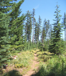
rhodo ride
Rhododendron Ridge Area Topo Map
- TH: Ascend through a hillside meadow to the ridgeline from Cachebox Meadow. Pass the Hawk Mountain Tr564A intersection on the right at 1.7mi, near Round Meadow.
- 2.6mi: After completing the third ascent, start the steady descent to Graham Pass. Watch for treefall and keep the speed under control.
- 4.4mi: Cross FR270, then descend to the Fawn Meadow FR270 crossing at 5mi.
- 6.1mi: Cross FR6350 at Graham Pass, then ascend steeply up the ridge for 1.2mi, traverse a knoll then complete the Mount Lowe ascent. Pass FR026 on the right at the 8.9mi ride summit.
- 9.4mi: Turnaround near the Mount Lowe peak, and return to the TH. Option: use FR6350 to return from Graham Pass to Cachebox Meadow.


Bull of the Woods Wilderness Hiking

Dickey Creek Tr553 provides the earliest access to the Bull of the Woods Wilderness and a direct route to the popular Big Slide Lake, passing through deep forest in the Dickey Creek drainage for the first three miles, then ascending to the ridge above Big Slide Lake.
Shreiner Peak Tr555 is a great hike to the small alpine Lake Lenore, with views of the surrounding peaks and Welcome Lakes while passing through several meadows. From Welcome Lakes Tr554, the trail descends a steep north-facing slope for .6mi to the junction with Dickey Creek Tr553. Shreiner Peak Tr555 descends steeply off the Big Slide Mountain saddle and enters a large burn area before reaching Lake Lenore.
Welcome Lakes Tr554 is the major east-west connector between the Bull of the Woods summit and Elk Lake Creek Tr559, traversing a range of terrain from deep old growth to open rocky ridges and intersecting with many of the other trails.
Elk Lake Creek Tr559 follows Elk lake Creek through very large Douglas and True Fir old growth forest, June rhododendrons and waterfalls, to the Welcome Lakes Tr554 intersection, then continues the ascent to Elk Lake. The hike involves several creek crossings, notably at Pine Cone and Knob Rock creeks, and Elk Lake creek as well (a dangerous high water crossing).
Mother Lode Tr558 passes through old growth Douglas Fir, True Fir and Mountain Hemlock with views of Mount Jefferson, with several creek crossings along the way.
Bull of the Woods Tr550 is a popular day hike, traversing the west slopes of North and South Dickey Peaks, offering views of Mount Hood, Three Sisters, Mount Jefferson and Three Fingered Jack. Visit the fire lookout at the south end of the trail for more views of the surrounding area.
The popular Pansy Lake Tr551 ascends 1,000’ in 2mi to the ridge top beyond the lake. From Pansy Lake, the trail ascends steep, rocky terrain .7mi to the Mother Lode Tr558 intersection.
Twin Lakes Tr573 is the most popular trail, as an easy access loop connector. Note: FR4697 is a rough jeep trail.
Bagby Hot Springs Tr544 follows Hot Springs Fork of the Collowash River and passes through old growth trees to the open-air tubs at Bagby Hot Springs, continuing south 5.6mi, crossing 14 streams before reaching a spur trail intersection (to Silver King Lake). Bagby Hot Springs Tr544 then switchbacks 1mi to the ridge and Whetstone Tr546 intersection. Whetstone Tr546 becomes Whetstone Tr3369 in the Willamette NF and continues past Wildcat Swamp and into the Horse Lake area.
Trail Index
This Ride
Mount Lowe Trail 562, Rhododendron Ridge Trail 564
Area
Bald Butte Trail 3360, Burnt Granite Trail 595, Fish Lake Trail 717, Lodgepole Trail 706, Pioneer Bridal Trail 795, Red Lake Trail 719, Rhododendron Urban Link Trail 564, Riverside National Recreation Trail 723, Still Creek Trail 780
Sandy Ridge Trails
Hiking
Cache Meadow Trail 702, Corral Springs Trail 507, Cripple Creek Trail 703, Dry Ridge Trail 518, Grouse Point Trail 517, Huxley Lake Trail 521, Hawk Mountain Trail 564A, Rhododendron Creek Trail 569, Serene Lake Trail 512, Shellrock Lake Trail 700
Campgrounds
Frazier Campground, Hideaway Lake Campground, Indian Henry Campground, Lake Harris Campground, Rainbow Campground, Ripplebrook Campground, Roaring River Campground, Shellrock Creek Campground, Sunstrip Campground
Trail Rankings
Ranking consistently applied to all of the listed trails.
- Overall Rating: Ride quality and challenge
- Aerobic: Ascent challenge
- Technical Difficulty: Terrain challenge
- Steepness: Average incline
- Flow: Uninterrupted riding
- Elevation Change: Total elevation gain
- Ride Difficulty: Terrain challenge
