
Timberline Trails
Twitter Search
#MtHoodTimberline

Overall: 4
Aerobic: 5
Technical: 5
Steepness: 6
Flow: 5
Singletrack: 40%
The short but steep Mount Hood Oregon Timberline to Town Trail is best tackled as a shuttle ride, from Timberline to Gov't Camp.
Type
Loop
Length
Avg: 7.5mi
Ascent
Moderate
Elevation Change
TH:4000'
Avg Ascent:1800'
Ascent Incline
7%
Duration
Avg: 1.5hr
Weather
Forecast
NOAA
popup
USFS
A 6mi road climb for 6mi of often doubletrack descent may not seem like a great bargain, but (as with the Timberline Bike Park trails) this is mostly shuttled so Timberline to Town is popular and gets a lot of use.
The Area map includes the Timberline and SkiBowl bike park trails, with shuttle service and terrain well suited for downhill riding.
Most of the Bike Park trails are about 2mi in length, with a few like the twisty Gravy Train trail at 4mi. The ability to choose various routes keeps it interesting.
At 14%, the descent is steep, and somewhat technical if only because of the speed potential, with seasonal erosion keeping things interesting while tempting the rider to get out of control..
The Timberline Trail can be combined with Pioneer Bridal Tr795 with a shuttle.
Directions: See Map. Start in Gov't camp from the Crosstown Tr755 TH or shuttle. View Larger Map. No Map?.

Loop Directions
waterbars
- TH: From the Crosstown Tr755 TH
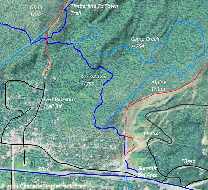
View of the Timberline Crosstown TH, climb 500' then go right to FR2645 and ascend to the Lodge. - 6.1mi: From the Lodge area, pass Alpine Tr660 and continue to Timberline to Town for the bombing run. Watch for jumps and waterbars and try to keep the speed under control.
- 10.8mi: Go left onto Crosstown Tr755 and ride back to the TH, or go right and ride some or all of Pioneer Bridle Tr795 OAB.


Mount Hood Wilderness Hiking

Timberline Trail 600, Pacific Crest Trail 2000-G and surrounding trails form a hub and spoke trail system around Mount Hood in classic Pacific Northwest trails circumnavigating Mount Hood with alpine vistas, waterfalls, alpine meadows and west side Cascade forest.
This section of the Pacific Crest Trail extends from Barlow Pass to Lolo Pass, with Timberline Trail 600 surrounding the north and east sides of Mount Hood at the treeline, from Yocum Ridge to Timberline Lodge.
Timberline Trail 600 was constructed by the Civilian Conservation Corps in the 1930’s, with challenging glacial-fed drainages crossing Newton, Coe, Muddy Fork, Sandy and White Rivers.
Wilderness permits are required and locator beacons are suggested. Mount Hood Summit info. Don't become a statistic, be prepared, especially if climbing above Timberline Tr600. Consider using a guide if not experienced climbing Mt Hood.
The large Area Maps on the following pages cover most of this trail system Tilly Jane Trail 643, East Fork Trail 650, Sahalie Falls Trail 667C, Pioneer Bridle Trail 795.
Hidden Lake Tr779 ascends to a small wooded lake through rhododendron bushes, with a challenging 12mi loop created by combining Hidden Lake Tr779 with the Pacific Crest Tr2000 for 2.4mi, then returning 5.6mi on Paradise Park Tr778.
The Riley Horse Camp is the trailhead for the Cast Creek, Horseshoe Ridge and Sandy River trails.
Zigzag Mountain Tr775 is the primary east-west connector from FR18 to Pacific Crest Tr2000, with two abandoned lookout sites alongside the trail.
Paradise Park Tr778 is a steady ascent along a forested ridge above the north side of the Zigzag River, eventually accessing Pacific Crest Tr2000 and the Paradise Park alpine meadow with views of Mount Hood.
Yocum Ridge Tr771 ascends to one of the most pristine, fragile and accessible alpine meadows in the Mount Hood Wilderness. Hike 4mi from the Ramona Falls Trailhead to the western Yocum Ridge Tr771 terminus.
Vista Ridge Tr626 is one of the shorter routes to Timerline Tr600 and can be combined with the Eden Park loop. Popular destinations from the Timerline Tr600 intersection include Elk Cove, Barrett Spur, Eden Park, Cairn Basin and Wy'east Basin
The very popular Ramona Falls Tr797 is accessed from Sandy River Tr770 and leads to a very popular falls area, with views of volcanic debris along the way. The Sandy river has a footbridge from Spring to Fall.
Horseshoe Ridge Tr774 western trailhead is 500 feet before the entrance into Riley Campground and starts with the 'Old Maid Flat' area, prior to crossing Lost Creek. The trail enters alpine forest and can be looped with Cast Creek Tr773.
Trail Index
This Ride
Alpine Trail 660, Crosstown Trail 755, Glade Trail 661, Timberline to Town Trail
Timberline Bike Park
Ant Farm Trail, Brobi-Wan Trail, Camino de Michoacan CDM Trail, Dirtbag Down Trail, Gotta-Go Trail, Gravy Train Trail, Quandry Trail, Re-Align Trail, The Rock Trail, Xerces Trail
SkiBowl Bike Park
Cannonball Trail, Fire Hydrant Trail, Gnar-Gnar Trail, Optimator Trail, Powerline Trail, ProLine Trail, South Trail, Sunrise Trail, Sunset Trail, Summit Trail 691
Area
Bonney Meadows Trail 471, Bottle Prairie Trail 455, Boulder Lake Trail 463, Casey Creek Trail 476, Cedar Creek Trail 457, Cooks Meadow Trail 639, Dog River Trail 675, East Fork Trail 650, Eightmile Creek Trail 459, Fifteenmile Trail 456, Forest Creek Trail 473, Gumjuwac Trail 480, Gunsight Trail 485, Hidden Meadows Trail 472, Horkelia Meadows Trail 20, Knebal Springs Trail 474, Lookout Mountain Trail 450, Oak Ridge Trail 688A, Pioneer Bridle Trail 795, Pocket Creek Trail 684, Polallie Ridge Trail 643A, Sahalie Falls Trail 667C, Surveyors Ridge Trail 688, Tilly Jane Trail 643, Umbrella Falls Trail 667, Underhill Trail 683, Zig Zag Trail 678
Sandy Ridge Trails
Mount Hood Wilderness and Other Hiking
Barlow Trail 601A, Burnt Lake South Trail 772, Cast Creek Trail 773, Cast Lake Trail 796, Devils_Tie Trail 767, Hidden Lake Trail 779, Horseshoe Ridge Trail 774, Mazama Trail 625, McNeil Point Trail 600M, Mountaineer Trail 798, McGee Creek Trail 627, Little Zigzag Falls Trail 795C, Mt Hood Summit Route, Pacific Crest Trail 2000-G, Paradise Park Trail 778, Paradise Park Loop Trail 757, Ramona Falls Trail 797, Sandy River Trail 770, Timberline Trail 600, Top Spur Trail 785, Trillium Lake Trail 761, West Zigzag Trail 789, Yocum Ridge Trail 771, Zigzag Mountain Trail 775
Campgrounds
Alpine Campground, Camp Creek Campground, Devils Half Acre Campground, Lost Creek Campground, McNeil Campground, Riley Campground, Still Creek Campground, Tollgate Campground, Trillium Lake Campground
Trail Rankings
Ranking consistently applied to all of the listed trails.
- Overall Rating: Ride quality and challenge
- Aerobic: Ascent challenge
- Technical Difficulty: Terrain challenge
- Steepness: Average incline
- Flow: Uninterrupted riding
- Elevation Change: Total elevation gain
- Ride Difficulty: Terrain challenge
