Crystal Mountain Tr1163
Twitter Search
#crystalmountain

Overall: 6
Aerobic: 7
Technical: 6
Steepness: 6
Flow: 5
Singletrack: 85%
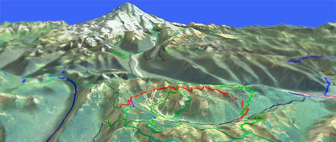
With a 6582' summit, the Stevens Pass Washington Crystal Mountain Tr1163 is a high-elevation, high-summer loop which offers great views of Mountain Rainier and the White River valley.
Type
Loop
Length
Avg: 11mi
Ascent
Intense
Elevation Change
TH:4000'
Avg Ascent:4700'
Ascent Incline
10%
Duration
Avg: 3hr
Weather
Forecast
NOAA
popup
USFS
Trail
Review
After the initial ascent, the trail continues to challenge riders as it winds along, just below the Crystal Mountain ridgeline.
As is nearly always the case, it is easier to ride the top of a ridge than to ride a parallel track.
The result of riding an off-piste ridgeline trail is a number of short, steep climbs and descents, just to maintain elevation.
A typical ski resort ride, Crystal Mountain Tr1163 consists of short sections of singletrack stitched together with doubletrack.
Those seeking contiguous, back country singletrack should look elsewhere.
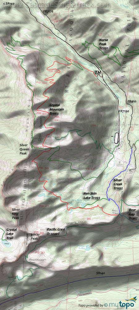
Ridgeline ride? The 2.2mi FR410 (sometimes called FR184) climb is easy enough, with a steeper ascent on Silver Cr Tr1192 to (the oddly named) Hen Skin lake, followed by a 2mi ascent to the ridgeline, then 2mi of actual ridgeline riding before the steep, equestrian-dodging descent back to the TH.
Those seeking more ridgeline in the area might try Noble Knob Tr1184.
Norse Peak Hiking
The Area topo map includes the nearby Norse Peak Wilderness trails, with several good day-hike options from Crystal Mountain or SR140.
With easy access from the resort, expect traffic on Norse Peak Tr1191, Goat Lake Tr1161 and Bullion Basin Tr1156 looped with Pacific Crest Tr2000. Bullion Basin Tr1156 south fork is closed due to erosion on the steep terrain.
Crow Lake Way Tr953 and Union Creek Tr956 offer more seclusion and are easily accessible from SR140, with camping nearby.
Directions: SR410E from Enumclaw 33.1mi to FR7190 (Crystal Mountain Rd). Go 4.4mi then go right (south) on FR7190-510 for 0.4mi to the Sand Flats camping area and TH. View Larger Map. No Map?.

Loop Directions
super bowl
Crystal Mountain Area Topo Map
- TH: From Sandy Flats, go left on FR7190 then go .4mi to FR140 and begin the climb (as shown on the profile map). Pass Norse Peak Tr1191 at 1mi and continue climbing FR410.
- 3mi: At the sharp turn, take Silver Cr Tr1192 (the middle trail). The trail turns to singletrack in .4mi, passes a chairlift (crossing a ski slope), then crosses a bridge at the Silver Creek mine and enters the woods.
- 4.5mi: Go right (across the creek) at the 4way spur junction. The trail to the left goes to Bear Gap and the PCT Tr2000 (hiker only). Reach Chair-4 at 4.9mi and go left onto the doubletrack trail.
- 5.1mi: Reach Hen Skin lake and ride around the south side of the lake, then merging with Crystal Mt Tr1163 and ascending to Miners Lakes, bearing right at the fork (5.1mi). Cross the creek and go left at the doubletrack, towards the chairlifts. After 500', rejoin Crystal Mt Tr1163.
- 7.2mi: Switchback climb to the saddle. At the doubletrack go on the trail to the left, climbing .2mi to the doubletrack (at the boulder field), then go right. Begin the sub ridgeline section, maybe stopping at the Summit House along the way. Go along the ridgetop doubletrack to the chairlift, then pick up the trail behind the chairlift.
- 8.7mi: Go left at the fork, then begin the steep descent back to the Sandy Flats camping area.
Trail Index
This Ride
Crystal Mountain Trail 1163, Hen Skin Lake Trail 1193, Silver Creek Trail 1192
Area
Bone Lake Trail 1172.1, Buck Creek Trail 1169, Christoff Trail 1171, Dalles Ridge Trail 1173, Deep Creek Trail 1196, Divide Trail 1172, Doe Falls Trail 1174, Grass Mountain Trail 1170, Noble Knob Trail 1184, Palisades Trail 1198, Ranger Creek Trail 1197, Skookum Flats Trail 1194, Suntop Trail 1183, White River Trail 1199
Norse Peak Hiking
Basin Trail 987, Basin Lake Trail 987A, Bear Gap Trail 967, Bullion Basin Trail 1156, Cougar Valley Trail 951A, Crow Lake Way Trail 953, Fog City Trail 967A, Goat Lake Trail 1161, Norse Peak Trail 1191, Pacific Crest Trail 2000-I, Union Creek Trail 956
William O Douglas Hiking
American Ridge Trail 958, Dewey Lake Way Trail 968, Kettle Creek Trail 957, Mesatchee Creek Trail 969, Pleasant Valley Loop Trail 999
Mount Rainier NP Hiking
Crystal Lake Trail, Eastside Trail, Naches Loop Trail
Campgrounds
Corral Pass Campground, The Dalles Campground, Lodgepole Campground, Pleasant Valley Campground, Silver Springs Campground, White River Campground
Trail Rankings
Ranking consistently applied to all of the listed trails.
- Overall Rating: Ride quality and challenge
- Aerobic: Ascent challenge
- Technical Difficulty: Terrain challenge
- Steepness: Average incline
- Flow: Uninterrupted riding
- Elevation Change: Total elevation gain
- Ride Difficulty: Terrain challenge


