North Umpqua River Trail: Swiftwater to Steamboat Tr1414
Twitter Search
#northumpquatrail

Overall: 7
Aerobic: 5
Technical: 5
Steepness: 5
Flow: 8
Singletrack: 100%
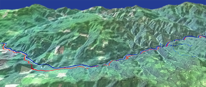
The Swiftwater Oregon to Steamboat North Umpqua Trail combines the Tioga and Mott sections into an easy riverside ride, with enough short climbs to keep it challenging and interesting for reasonably fit beginner to intermediate riders.
The 2020 Archie Creek fire affected the area from the Susan Creek Campground to Steamboat. See the Umpqua NF Site for closure maps.
As always, it is best to call the local Ranger District for trail conditions and other restrictions prior to visiting, as the UNF website may not contain trip-specific details.
Type
OAB
Length
Avg: 37mi
Ascent
Easy
Elevation Change
TH:900'
Avg Ascent:7500'
Ascent Incline
4%
Duration
Avg: 6hr
Weather
Forecast
NOAA
popup
USFS
Although it is a fast ride, the full OAB length will be too much for some riders.
Use of a shuttle from Steamboat to Swiftwater would greatly reduce the aerobic challenge, possibly including the Panther section, starting from the FR4714 Apple Creek campground.
The 1mi Bob Butte section offers the toughest climbing, with an 850' ascent at a 16% grade, too much for beginners and many intermediates, but it is a short enough hike to be manageable.
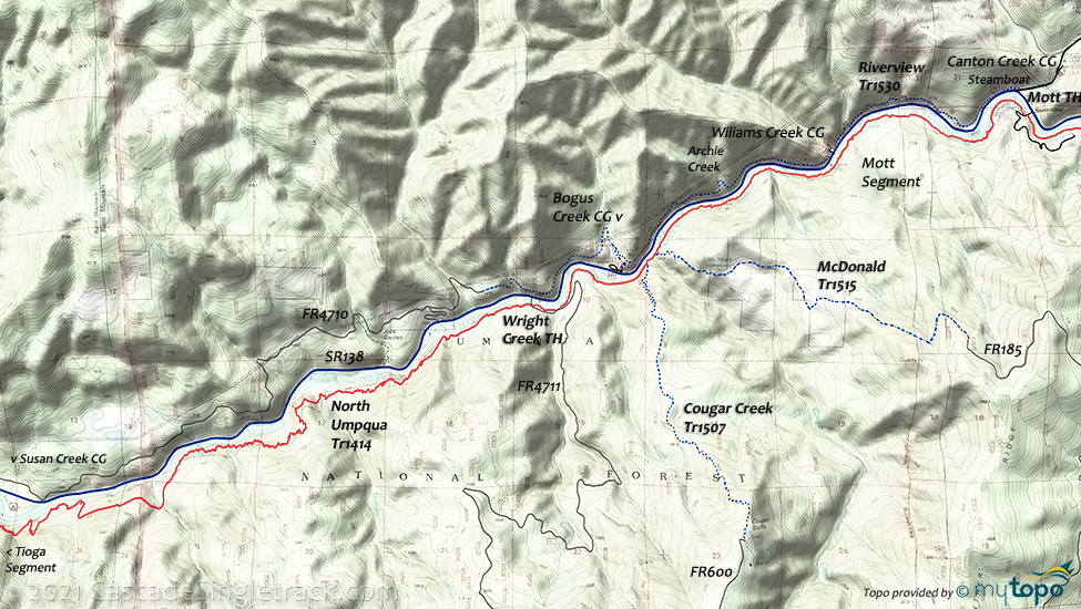
Cougar Creek Tr1507 and McDonald Tr1515 trails are too steep for an OAB ride, but a shuttle is possible, when the local fireroads are passable.
Be sure to keep a full tank of gas, and get other provisions before the ride, as the Steamboat shops are not 24/7.
Expect some trailside poison oak and prepare as needed. Try using Tecnu before the ride.
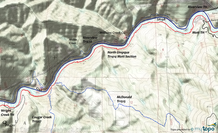
The Mott section of North Umpqua Tr1414 and Riverview Tr1530 can be used to create an 'Easy' 14mi (2300' ascent) CCW loop, which involves less elevation change than riding the Tioga section.
The ride can be extended by including the Panther section, as an OAB to the FR4714 Apple Creek campground.
Mott-Riverside CCW Loop
TH: From the Wright Creek TH, cross Wright Creek on FR4711 then go right onto the trail and ride to the Mott Bridge TH.
5.3mi: Cross the Mott Bridge then go left on SR138 and cross Steamboat Creek and go .2mi to the Riverview Tr1530 TH. The trail starts with a moderate ascent to the Alder Creek crossing, pass the Williams Creek campground at 7.6mi, then pass the Tr1513 intersection on the right.
10mi: Pass the Bogus Creek campground trail on the left, then descend and climb out of the Bogus Creek drainage.
11.7mi: Cross Rasberry Creek, then the trail ends at the FR4710 T intersection. Go straight onto FR4710, then descend to Fairview Creek at 12mi.
12.5mi: Climb the Fairview Creek drainage and reach a SR138 access road. Go left and ride several switchbacks to SR138, then go left on SR138, to the FR4711 Wright Creek TH.
Directions: See Map. Cross the North Umpqua Bridge on Co Rd 895 (not shown on Google Map) and start the ride from the Swiftwater Park TH. View Larger Map. No Map?.

OAB Directions
river cruise
- TH: Ride from Swiftwater Park, past Fern Creek Falls at 1mi and on to the Bob Butte ascent, which begins at 2.7mi. Traverse the eastern flank of Bob Butte, reaching the ride summit at 3.8mi, then switchback down to county road 21.
- 6.5mi: Approach the river then traverse several drainages, reaching Thunder Creek at 11mi, then descend to FR4711.
- 13.3mi: The Tioga segment ends at the FR4711 Wright Creek TH. Go right on FR4711 and cross Wright Creek, then go right onto the singletrack, with .2mi on FR4711.
- 14.6mi: Pass the Cougar Creek Tr1507 intersection on the right, cross Cougar Creek, then pass the McDonald Tr1515 intersection on the right.
- 18.6mi: Reach the Steamboat Mott Bridge. Return to TH, with the option of using FR138 to access Riverview Tr1530 and riding that trail to the Wright Creek TH, then return to the Swiftwater TH on North Umpqua Tr1414.
Trail Index
This Ride
North Umpqua Trail 1414
Area
Cougar Creek Trail 1507, Dread and Terror Trail 1461, Mayflower Loop Trail 1559, McDonald Trail 1515, Riverview Trail 1530, North Umpqua Trail 1414 Dread and Terror Segment, North Umpqua Trail 1414 Marsters to Toketee Segment, North Umpqua Trail 1414 Panther to Marsters Segment
Campgrounds
Bogus Creek Campground, Canton Creek Campground, Susan Creek Campground, Williams Creek Campground
Trail Rankings
Ranking consistently applied to all of the listed trails.
- Overall Rating: Ride quality and challenge
- Aerobic: Ascent challenge
- Technical Difficulty: Terrain challenge
- Steepness: Average incline
- Flow: Uninterrupted riding
- Elevation Change: Total elevation gain
- Ride Difficulty: Terrain challenge


