Mount Margaret: Coldwater Tr230
Twitter Search
#mountmargaret

Overall: 7
Aerobic: 7
Technical: 5
Steepness: 6
Flow: 5
Singletrack: 100%
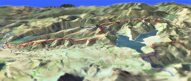
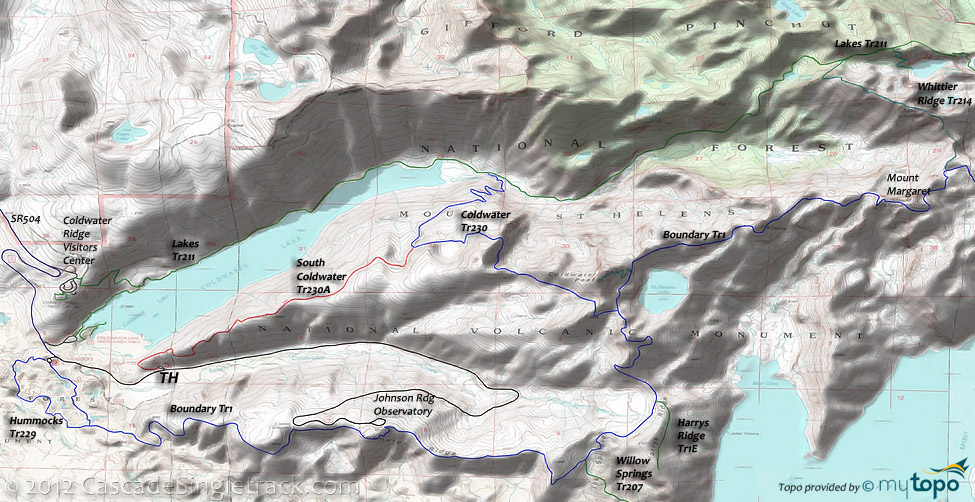
Coldwater Tr230 to Mount Margaret is a loop with a spur, like starting at the fat end of a lollipop ride.
Type
Loop
Length
Avg: 22.5mi
Ascent
Intense
Elevation Change
TH:6250'
Avg Ascent:6300'
Ascent Incline
11%
Duration
Avg: 6hr
Weather
Forecast
NOAA
popup
USFS
Trail
Review
Note: As of Summer 2013, Boundary Tr1 from Norway Pass on FR26 to the Johnson Observatory is closed to biking. Trail Status. Check with the ranger district before attempting to ride any of that section.
This ride covers all of the terrain which is allowed for biking. The remainder of Coldwater Tr230 and Lakes Tr211 are off limits.
Once the trail breaks out of the woods into the blast zone, it can get hot in the summer so bring plenty of water.
Be ready for sandy, loose trail conditions.
Hiking: Lakes Tr211 extends from SR504 nearly to FR26, passing many lakes along the way, with several good loop options as well. Best attempted from FR99, using Independence Pass Tr227, Whittier Ridge Tr214 and Lakes Tr211 create a nice days hike around Panhandle Lake, Shovel Lake, Twin Lakes and Grizzly Lake. Be prepared for extreme terrain and bring plenty of supplies.
Boundary Tr1 continues across the ranger district ridgeline border to High Lakes Tr116.
Directions: See Map. Take exit 49 to SR504, then go east and park at the South Coldwater TH. View Larger Map. No Map?.

Loop Directions
blast zone lollipop
- Note: With Boundary Tr1 closed to biking, this ride is limited to a 11mi OAB on South Coldwater Tr230A and Coldwater Tr230. The rest of the directions listed are for hiking until Boundary Tr1 is reopened to biking.
- TH: Steady 1550' switchback ascent for 3.2mi on South Coldwater Tr230A, past some logging equipment destroyed from the 1980 eruption.
- 3.2mi: Go right onto Coldwater Tr230 and ascend 1400' over 2.4mi, an 11% grade.
- 5.6mi: (Return to TH if biking). Go left onto Boundary Tr1 and ascend the undulating ridgeline terrain past the Coldwater Peak Tr1G intersection and Saint Helens Lake at 6mi, then pass The Dome at 7.3mi, reaching the Mount Margaret ride summit at 8.9mi.
- 8.9mi: Turn around and head back to SR504 on Boundary Tr1. Pass the Coldwater Tr230 intersection and descend past the Harrys Ridge Tr1E intersection at 13.9mi. Traverse The Spillover, passing the Willow Springs Tr207 intersection on the left at 14.9mi, then ride the flat ridgeline terrain to the Johnson Ridge Observatory.
- 17.1mi: Just past the Johnson Ridge Observatory, Boundary Tr1 breaks into a steep, 3.5mi switchback descent to SR504, with 1mi of flat terrain just prior to reaching the road. Pass the Hummocks Tr229 intersection on the left at 20.6mi.
- 21.6mi: Go right onto SR504 and ride .9mi to the TH.
Trail Index
This Ride
Boundary Trail 1, Coldwater Peak Trail 1G, Coldwater Trail 230, Harrys Ridge Trail 1E, Hummocks Trail 229
Area
Wilderness
Birth of A Lake Trail 246, Castle Lake Trail 221, Harmony Trail 224, Independence Pass Trail 227, Lakes Trail 211, Loowit Trail 216, Panhandle Lake Trail 211B, Shovel Lake Trail 211C, Whittier Ridge Trail 214, Windy Trail 216E, Willow Springs Trail 207, Winds of Change Trail 232
Trail Rankings
Ranking consistently applied to all of the listed trails.
- Overall Rating: Ride quality and challenge
- Aerobic: Ascent challenge
- Technical Difficulty: Terrain challenge
- Steepness: Average incline
- Flow: Uninterrupted riding
- Elevation Change: Total elevation gain
- Ride Difficulty: Terrain challenge


