Pyramid Mountain Tr1433

Overall: 9
Aerobic: 8
Technical: 7
Steepness: 8
Flow: 6
Singletrack: 100%
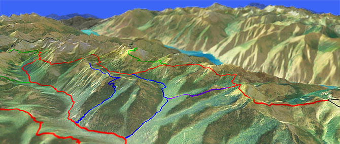
The Chelan Washington Pyramid Mountain Trail is an OAB ridge ride to Pyramid Mountain and beyond, on one of the highest elevation rides in the Cascade Range.
Type
OAB
Length
Avg: 26.5mi
Ascent
Moderate
Elevation Change
TH:6600'
Avg Ascent:9000'
Ascent Incline
13%
Duration
Avg: 8hr
Weather
Forecast
NOAA
popup
USFS
Trail
Review
Like most ridge rides, Pyramid Mtn Tr1433 is undulating, with moderate to steep ascents.
You won't find many downhillers on this one...or at least not any that are having fun.
Hiking: Best accessed from Lucerne (by ferry), the Glacier Peak Wilderness area to the west of Pyramid Mountain offers several epic backcountry hiking loops.
As one of the highest elevation rides in the Cascade Range, Pyramid Mountain Tr1433 is more rugged than the usual ridgeline ride, so be ready for some serious climbing...in both directions, because this one does not relent.
Pyramid Mountain Tr1433 can be combined with North Fork Entiat River Tr1437 into several challenging loop options, covered on that page.
The ascent from Pyramid Creek Tr1439 to Grouse Pass is a 2mi, 1375' (13%) climb, with three other sustained climbs to 7000' peaks...in each direction.
The 5.2mi (1970' ascent) Pyramid View Point Tr1441 is a very challenging side excursion, a ride within a ride.
1400' of that ascent is in the final 1.6mi to the 8243' summit, a bike-pushing 16% grade.
Although this is not the Everest 'death zone', the summit hike may still lead to a lingering desire for bottled oxygen.
Directions: NW Forest Pass required right at the TH. SR971 (Navarre Coulee Rd) 30mi to the "T" in the road at the Lake Chelan shores. Turn left onto South Lakeshore Drive. Drive to Twenty-Five Mile Cr State Park. Just on the other side take left on Shady Pass Rd FR59. Go 14mi then go right onto FR112 then go 2mi to the TH. View Larger Map. No Map?.

OAB Directions
pyramid ridge riding
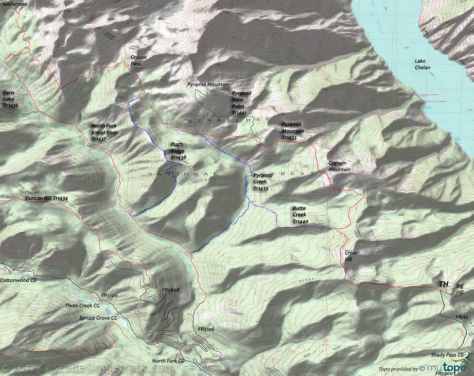
Pyramid Mountain Area Topo Map
- TH: From the Big Hill trailhead, ride FR112 to the Pyramid Mountain Tr1433 TH, near the sharp left curve. Slight .6mi descent, followed by a 500' ascent to Silver Ridge at 1.5mi. Ride 1mi along the ridge to Crow Hill, then navigate a switchback descent of 800' over the next 1mi to the Butte Creek headwaters, blazing past the Butte Cr Tr1440 intersection on the left at 2.9mi (bear right to stay on the trail).
- 3.5mi: From the Butte Creek headwaters, ascend 1.5mi and 950' to the Graham Mtn summit, with steep, rocky terrain giving way to a more moderate ascent. The trail then breaks away the ridgeline for the remainder of the ride.
- 6.5mi: Misery Option: Take a right on Pyramid View Pt Tr1441, which is mostly rideable for 1mi, before turning into a rocky hike-a-bike trek to the summit. Otherwise, descend 1100' over 1mi to Pyramid Creek Tr1439 intersection.
- 7.6mi: From the Pyramid Creek Tr1439 intersection, grind 1381' over the next 2mi to Grouse Pass, the toughest climb of this ride. The last .5mi will be hike-a-bike for most riders.
- 9.6mi: From Grouse Pass, descend 800' over 1mi, to just above the Grouse Creek headwaters, then traverse the side of the Cardinal Peak hillside. The last 2mi to the turnaround point is relatively flat, but uneven.
- 12.2mi: Pass the N. Fork Entiat Rvr Tr1437 intersection on the left and continue for 1mi (stopping short of the final ascent to Saska Pass), then return to the TH.
Trail Index
This Ride
Butte Creek Trail 1440, Pugh Ridge Trail 1438, Pyramid Creek Trail 1439, Pyramid Mountain Trail 1433, Pyramid View Point Trail 1441
Area
Angle Peak Orv Trail 1444, Anthem Creek Trail 1435, Billy Creek Trail 1416, Billy Ridge Trail 1413, Blue Creek Orv Trail 1426, Cougar Mountain Orv Trail 1420, Cougar Ridge Orv Trail 1418, Devils Backbone Orv Trail 1448, Duncan Hill Trail 1434, Entiat River Trail 1400, Fern Lake Trail 1436, Four Mile Ridge Orv Trail 1445, Hunters Orv Trail 1417, Lake Creek Orv Trail 1443, Hi Yu Orv Trail 1403, Hornet Ridge Trail 1410, Jimmy Creek Trail 1419, Lost Lake Orv Trail 1421, Mad River Orv Trail 1409, Middle Tommy Orv Trail 1424, Miners Ridge Trail 1411, Myrtle Lake Trail 1404A, North Fork Entiat River Trail 1437, North Tommy Orv Trail 1425, Pond Camp Trail 1409.2, Shetipo Orv Trail 1429, South Tommy Orv Trail 1423, Three Creeks Trail 1428, Tyee Ridge Orv Trail 1415
Glacier Peak Wilderness Hiking
Domke Lake National Recreation Trail 1280, Domke Mountain Lookout Trail 1280.1, Emerald Park Trail 1230, Lower Railroad Creek Trail 1240.2, Mirror Lake Tr1230.1, 45 Mile Drive Trail 1432
Campgrounds
Big Hill Campground, North Fork Campground, Shady Pass Campground
Trail Rankings
Ranking consistently applied to all of the listed trails.
- Overall Rating: Ride quality and challenge
- Aerobic: Ascent challenge
- Technical Difficulty: Terrain challenge
- Steepness: Average incline
- Flow: Uninterrupted riding
- Elevation Change: Total elevation gain
- Ride Difficulty: Terrain challenge


