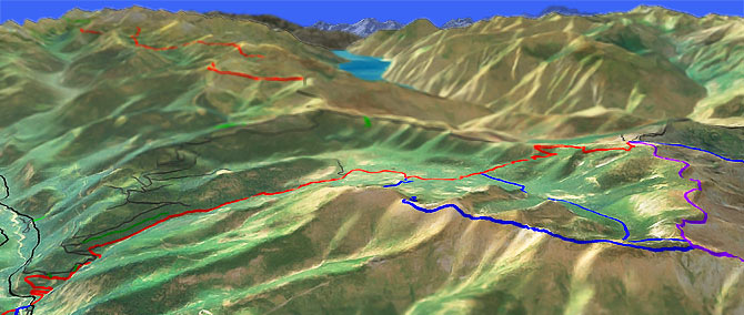
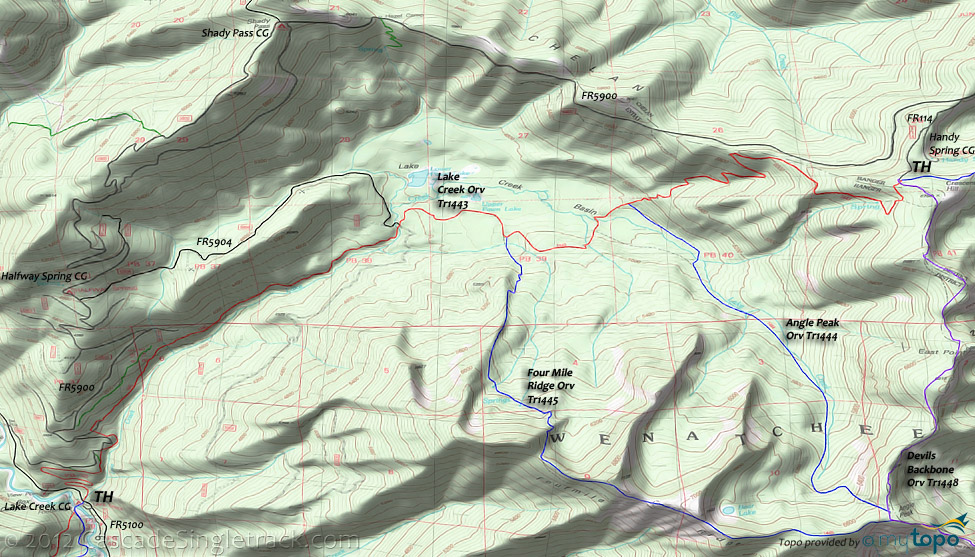
Lake Creek Orv Tr1443
Twitter Search
#LakeCreekTrail

Overall: 8
Aerobic: 10
Technical: 8
Steepness: 8
Flow: 5
Singletrack: 100%
The Entiat Washington Lake Creek Trail is a steep ascent from the Entiat River basin past the Lake Creek basin and up to the rugged, angular Devils Backbone ridgeline.
Type
Loop
Length
Avg: 22mi
Ascent
Mt Goat
Elevation Change
TH:2200'
Avg Ascent:6500'
Ascent Incline
11%
Duration
Avg: 6hr
Weather
Forecast
NOAA
popup
USFS
Easy TH access ensures heavy weekend ORV traffic, and the elevation shortens the ride to July-August, so find a nice summer weekday to experience this ride.
Instead of starting this perfectly good ride with an 'epic' 13mi fireroad ascent, either start from the Halfway Spring campground and ride out FR5904, or (for stronger climbers or those willing to do some hike-a-bike) simply start from the Lake Creek campground TH.
Either way, after climbing to the top of Lake Creek Orv Tr1443 and riding Devils Backbone Orv Tr1448 to Angle Peak, either return on Four Mile Ridge Orv Tr1445 or Angle Peak Orv Tr1444 and head back to the TH.
The 18mi FR5904 ride involves 4700' of climbing and offers excellent views of the Pawn Lakes and the Lake Creek basin.
Four Mile Ridge Orv Tr1445 is the more rugged return option, passing Bear Lake then dropping off the angular ridgeline into the basin.
Directions: NW Forest Pass required right at the TH. 29mi from Entiat. Entiat River Rd to FR51 then either start from the Lake Cr. CG or cross the Entiat river upstream on FR5606 (from FR51) and drive down to the TH. View Larger Map. No Map?.

Loop Directions
only the first 8 miles of the FR climb are steep..
- TH: Ascending from the Lake Creek campground TH, tackle .8mi of rough terrain through three switchbacks. Ascending the Lake Creek drainage, reach FR5900 at 1.45mi, near a curve in the road, then cross some doubletrack and parallel FR5900 until 2.7mi.
- 4.5mi: As the trail opens up into the Lake Creek basin, cross Lake Creek then cross FR5904, maybe wishing that had been the trailhead. Pass Upper Pawn Lake at 5.1mi.
- 5.5mi: Pass the Four Mile Ridge Orv Tr1445 intersection on the right, then cross several Lake Creek tributaries. Pass the Angle Peak Orv Tr1444 intersection on the right at 6.5mi and start the final switchback ascent to the Devils Backbone Orv Tr1448 TH.
- 9.2mi: Go right onto Devils Backbone Orv Tr1448 TH, with a brief climb leading to a rugged ridgeline, passing East Point on the way to the 3-ridged Angle Peak.
- 12.2mi: Pass the Angle Peak Orv Tr1444 intersection on the right then take Four Mile Ridge Orv Tr1445 and ascend 1.6mi to the Bear Lake overlook, then drop sharply off the ridge into a steep, switchback descent.
- 16.3mi: Go left onto Lake Creek Orv Tr1443 and return to the TH.
Trail Index
This Ride
Angle Peak Orv Trail 1444, Devils Backbone Orv Trail 1448, Four Mile Ridge Orv Trail 1445, Lake Creek Orv Trail 1443
Area
Anthem Creek Trail 1435, Billy Creek Trail 1416, Billy Ridge Trail 1413, Blue Creek Orv Trail 1426, Butte Creek Trail 1440, Cougar Mountain Orv Trail 1420, Cougar Ridge Orv Trail 1418, Duncan Hill Trail 1434, Entiat River Trail 1400, Fern Lake Trail 1436, Hunters Orv Trail 1417, Hi Yu Orv Trail 1403, Hornet Ridge Trail 1410, Jimmy Creek Trail 1419, Lone Peak Trail 1264, Mad River Orv Trail 1409, Middle Tommy Orv Trail 1424, Miners Ridge Trail 1411, Myrtle Lake Trail 1404A, North Fork Entiat River Trail 1437, North Fork Twentyfive Mile Creek Trail 1265, North Tommy Orv Trail 1425, Pond Camp Trail 1409.2, Pot Peak Trail 1266, Pugh Ridge Trail 1438, Pyramid Creek Trail 1439, Pyramid Mountain Trail 1433, Pyramid View Point Trail 1441, Shetipo Orv Trail 1429, South Tommy Orv Trail 1423, Three Creeks Trail 1428, Tyee Ridge Orv Trail 1415
Campgrounds
Big Hill Campground, Fox Creek Campground, Halfway Spring Campground, Handy Spring Campground, Junior Point Campground, Lake Creek Campground, Shady Pass Campground, Silver Falls Campground, Windy Camp Campground
Trail Rankings
Ranking consistently applied to all of the listed trails.
- Overall Rating: Ride quality and challenge
- Aerobic: Ascent challenge
- Technical Difficulty: Terrain challenge
- Steepness: Average incline
- Flow: Uninterrupted riding
- Elevation Change: Total elevation gain
- Ride Difficulty: Terrain challenge


