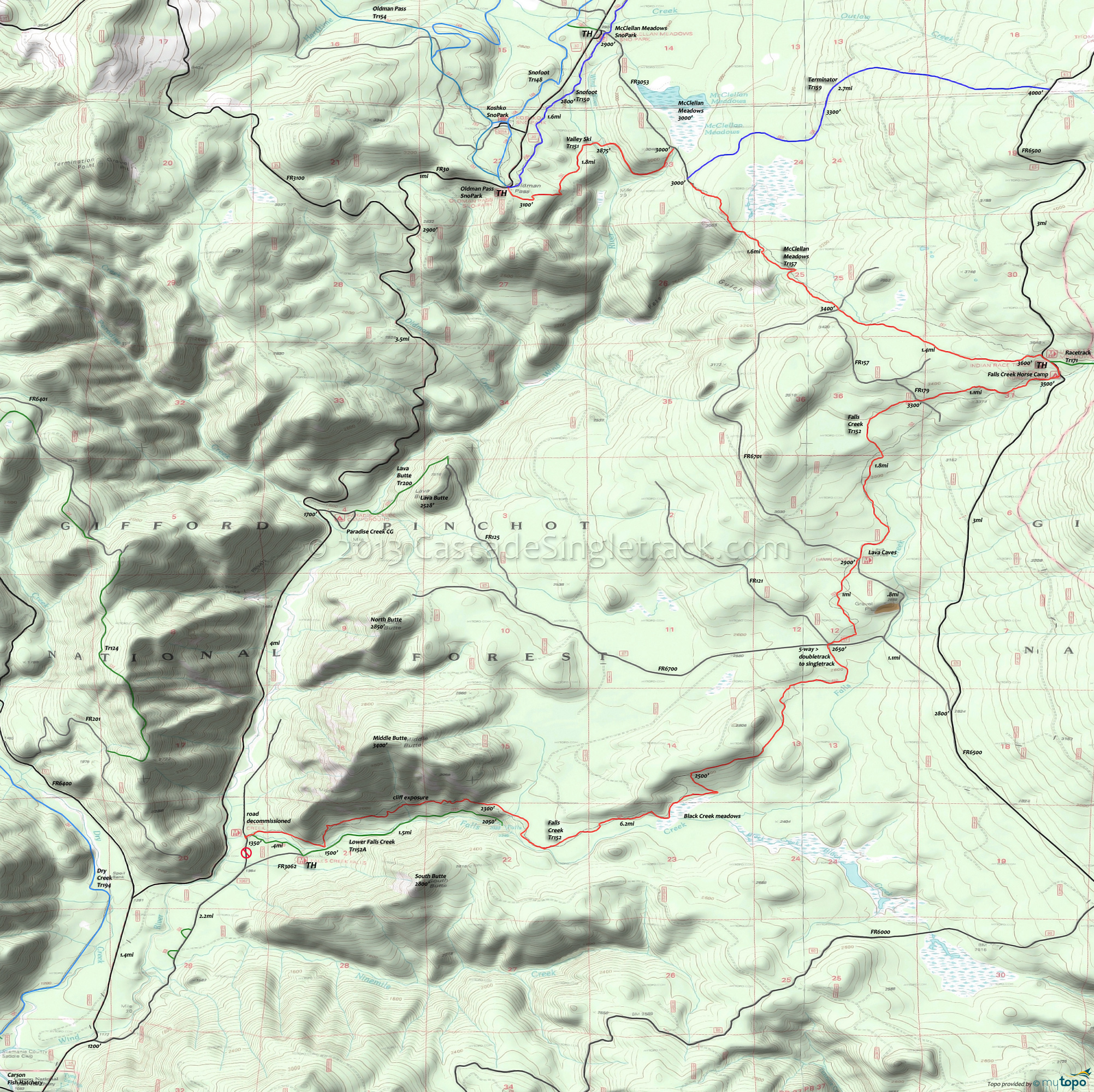
Falls Creek Trail 152 and Oldman Pass Trail 154 Area Mountain Biking and Hiking Topo Map
Map includes Dry Creek Trail 194, Falls Creek Trail 152, McClellan Meadows Trail 157, Oldman Pass Trail 154, Paradise Trail 153, Snofoot Trail 150, Terminator Trail 159 and Valley Ski Trail 151 Mountain Biking and Hiking Trails.
TH: From the Oldman Pass Sno-Park TH, ride across FR30 onto Snofoot Tr150 (next to the gravel road that accesses the kids sledding area). Snofoot Tr150 is a zippy downhill which parallels FR30. Ride through the Wind River drainage and then climb to FR3053.
1.6mi: Go right onto FR3053 and descend to to the end of the road, then go onto McClellan Meadows Tr157.
2.2mi: Ascend McClellan Meadows Tr157 over moderate terrain, climbing to a small campground, crossing a wooden bridge over Pete's gulch at 3.7mi, another bridge at 4.2mi and FR6701 at 4.7mi.
6.1mi: Go right onto FR6500, .2mi to the Falls Cr Tr152 TH, passing the Racetrack Tr171 TH on the left along the way. Go through the Falls Creek Horse Camp, at the top of the hill, then take Falls Cr Tr152 on the right.
7.3mi: The smooth trail gently descends, crossing FR179 then crossing FR6701 and passing the lava caves at 9mi. Look to the left for the big holes in the ground. Walk past this hole and find the next one. If you brought a bike lock (and maybe a light) or have someone to watch your ride, then crawl down into and 50yds through the first cave. Come back into the open then find the entrance to the larger cave. The lava tubes have 50ft ceilings and continue for miles.
10mi: After another amazing section of twisty singletrack, cross FR6700 at the 5-way intersection and note the sign for Falls Cr Tr152 (straight and to the left, when entering the road from the trail). Continue on doubletrack (for about .5mi, not shown on the map), which turns back into the trail.
12.2mi: After traversing a hillside on a sandy gravel surface, go through a sharp switchback and pass a marsh.
14.1mi: After zipping through the last section of fast singletrack, carefully descend the final 2mi to the TH. Really watch the speed on this section, as there are plenty of hikers and little room for error on the steep, gravel surface, which includes a few rooty drops along the way.
Draggable map: Map window adjusts to screen size and will respond to touch control. Use scrollbar for mouse control.
No Map? Browser settings and some browser extensions can prevent the maps from appearing. Please see Site Tech


