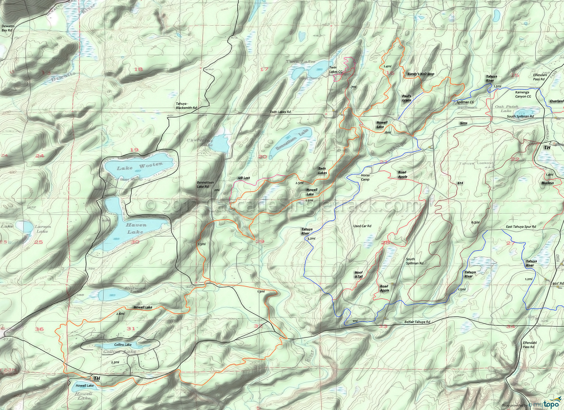
Tahuya State Forest: Howell Lake Trail, Twin Lakes Trail, Randy's H2O Stop Trail Mountain Biking and Hiking Topo Map
TH: From the picnic area, go left onto Howell Lake Trail just prior to reaching the Belfair Tahuya Rd. Pass a few spur trails then descend to the Belfair Tahuya Rd crossing at .3mi. Bear right at the fork, go 1mi then bear left at the fork. The Collins Lake area has many local trails so stick to the marked path.
2.6mi: After crossing several creeks, the paved road to Haven Lake and the dirt Bennettsen Lake Rd, go left at the Howell Lake Loop Trail 'T' intersection. Cross Bennettsen Lake Rd at 3.4mi then cross the Tahuya River at 3.9mi and ascend to the Twin Lakes Trail intersection, bearing left the fork just prior to reaching Twin Lakes Trail.
4.1mi: Go left onto Twin Lakes Trail, bearing right at the 4.4mi UB Lost Trail intersection near a Tahuya River tributary. Bear right at the 5.1mi UB Lost Trail intersection, then cross a gravel path at 5.3mi, rejoining the trail at 5.5mi. Note: Most of UB Lost Trail is part of a gravel doubletrack, which extends north to Twin Lakes Rd.
6.7mi: Go right onto the gravel doubletrack at 6.4mi and continue to Twin Lakes Road, then go right to the Randy's H2O Stop Trail intersection.
6.8mi: Go left onto Randy's H2O Stop Trail. Cross a doubletrack at 7.5mi, then go right onto that doubletrack at 8mi. Go left onto the trail at 8.4mi, pass Paul's Grade Trail at 8.9mi, then ride around a clearing to the Tahuya River Trail intersection.
9.7mi: Go right onto Tahuya River Trail. Cross Twin Lakes Rd at 10.2mi and go right onto Howell Lake Trail. Pass the 10.8mi Randy's H2O Stop Trail intersection on the right and cross the clearing to the 10.4mi Twin Lakes Trail intersection on the right.
13.9mi: Go left onto the Howell Lake Loop Trail, crossing a road at 14.2mi then paralleling the Tahuya River. Ride around a clearing then cross the Belfair Tahuya Rd at 15.1mi. Cross a Tahuya River tributary at 15.6mi then ascend to a 16.1mi clearing before paralleling the Belfair Tahuya Rd back to the TH.
Draggable map: Map window adjusts to screen size and will respond to touch control. Use scrollbar for mouse control.
No Map? Browser settings and some browser extensions can prevent the maps from appearing. Please see Site Tech


