
Smith Creek Trail 225 Area Mountain Biking and Hiking Topo Map
Map includes: Abraham Trail 216D, Ape Canyon Trail 234, Loowit Trail 216, Smith Creek Trail 225, Willow Springs Trail 207 Mountain Biking and Hiking Trails.
TH: The Ape Canyon portion of the ride starts with a .5mi rooty section alongside the usually dry Muddy River drainage, followed by the first great view of St Helens and 1mi of undulating trail.
1.5mi: Enter the switchback section, with a 1.5mi, 14% climb through 5 switchbacks, followed by a brief descent then a more gradual 1.5mi climb to the top.
4.6mi: Reach Butt Crack, formed by the lahar flow to Ape Canyon during the eruption. This is the beginning of the Loowit Tr216 section, which starts with a very narrow, cliff exposure section which often needs to be walked. This portion of the trail is undercut by erosion and at times can be quite dangerous. If you fall, you won't be doing anything else for the rest of the day...or maybe ever. 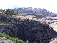
5.3mi: After traversing several drainages, Loowit Tr216 reaches the top of a waterfall, with a great view of Smith Creek and Mount Adams. The drainages can have significant flow from Spring till July and should be very carefully crossed if still snow packed, due to the high risk of breaking through the snow and becoming trapped. After the waterfall, the trail opens up onto the Plains of Abraham, with a slight grade and flat terrain.
6.2mi: Reach the Loowit Tr216 intersection, continuing straight onto Abraham Tr216D. Go through a drainage then a switchback ascent, followed by a descent to the Willow Springs Tr207 staircase and ridgeline trail over to FR9900. The ridgeline section consists of a narrow trail with moderate slope on each side, which tends to get the attention of most riders.
10.2mi: At FR9900, go left onto Smith Creek Tr225, on the north side of Windy Ridge, crossing FR9900 again at 11.7mi. Go out the ridge then begin 3mi switchback descent, being careful not to lose the barely marked trail, or simply losing it.
14.8mi: Reach Smith Creek and several stream crossings, to the west side of the channel.
17.2mi: Cross Ape Canyon Creek. Keep track of the trail location on the other side of the creek before crossing, as it is easy to miss. Additional stream crossings at 18.1mi and 18.8mi. Note the jeep track which parallels the trail, and leads to FR83 and FR8320.
19.3mi: Reach an abandoned portion of FR83, an alternative to climbing Lava Canyon Tr184 or FR8320. Go right when the trail reaches the wide, overgrown road. The intersection is marked with a rock cairn and a stick, where FR83 intersects with the creekside jeep track. FR83 barely exists at first, like riding across a grassy field, but becomes distinct as it reaches the treeline. This abandoned portion of FR83 has 3.2mi of undulating terrain, with a 1600' ascent and an 11% grade over the first 2mi.
19.6mi: The second climb option is Lava Canyon Tr184, described above and much steeper than climbing FR83. The first 1mi is a nearly unclimbable 15% grade.
19.8mi: Reach FR8320, the longest ascent option. The first 1.5mi is a 15% grade.

Draggable map: Map window adjusts to screen size and will respond to touch control. Use scrollbar for mouse control.
No Map? Browser settings and some browser extensions can prevent the maps from appearing. Please see Site Tech

