Windy Pass Tr3643
Twitter Search
#TimpanogasLake

Overall: 6
Aerobic: 6
Technical: 5
Steepness: 6
Flow: 5
Singletrack: 100%
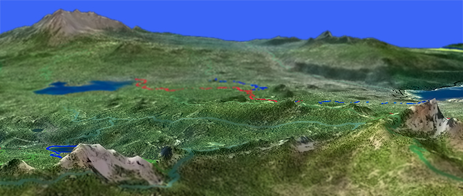
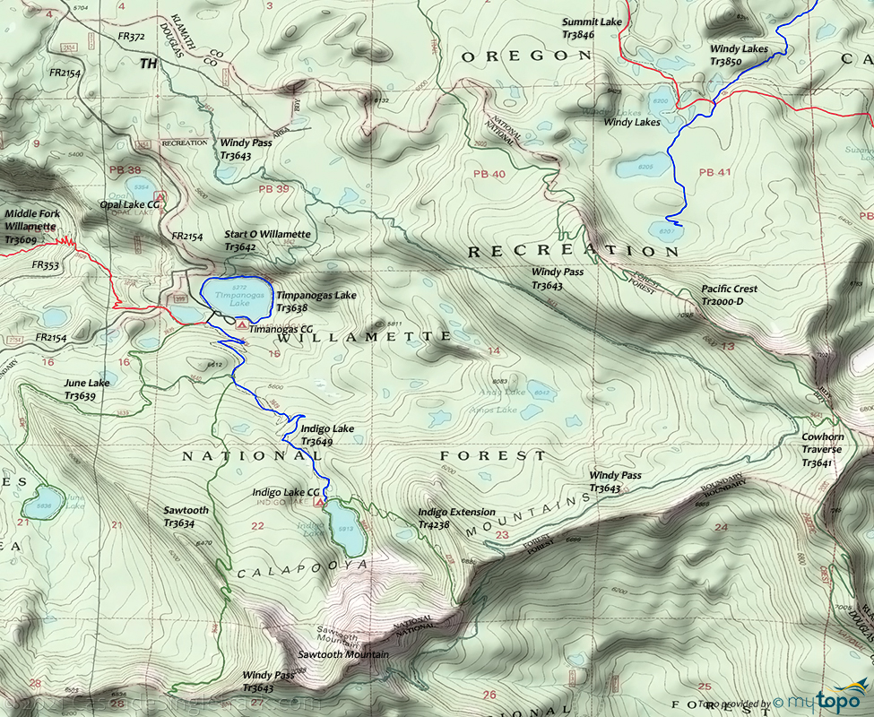
The Windy Pass Tr3643 loop is a hiking tour of high mountain lakes, at the edge of the Oregon Willamette National Forest.
Type
Loop
Length
Avg: 11.5mi
Ascent
Moderate
Elevation Change
TH:5250'
Avg Ascent:3500'
Ascent Incline
7%
Duration
Avg: 3hr
Weather
Forecast
NOAA
popup
USFS
Once open to biking, the trail is currently designated for hiking. Indigo Lake Tr3649 and Timpanogas Lake Tr3638 are still open for biking, if in the area to ride M. Fork Willamette Tr3609
The trail runs along the flank of the Cowhorn mountain and Sawtooth mountain ridgelines, to the west of Windy Lakes Tr3850 and just north of Dread and Terror.
This trail is short enough and inaccessible enough to offer a secluded hiking experience and this is one to check out for those seeking high mountain terrain.
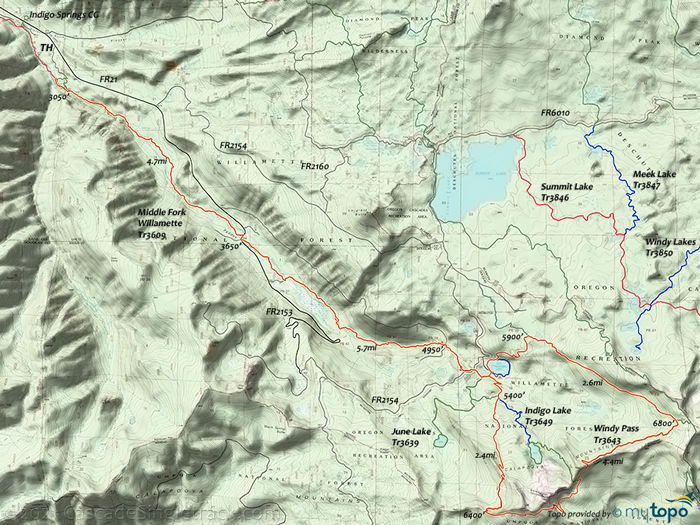
The CW Loop is often combined with some of M. Fork Willamette Tr3609, into a 33mi (7800' ascent) epic ride.
The Indigo Springs campground is a good TH for that lollipop, or start at FR404/Chuckle Springs.
On the upper section of Middle Fork Willamette Tr3609, expect washouts, pathfinding, treefall and all the other conditions of an infrequently used trail.
The trail stays close to forest roads, which makes bailing out an easy option.
River to Ridge Epic
TH: Easy climb from the Chuckle Springs TH, although some pathfinding may be required if visiting in the Spring. Near Paddy's Valley, dogleg to the right onto FR2153 at 5mi, crossing to the south die of the Middle Fork Willamette river.
7.6mi: Reach the end of the valley, just past Big Swamp. The ascent intensifies, and is occasionally a 10% incline.
10.7mi: Cross FR2154, then hike around a small lake, to Timpanogas Lake campground. Hike around the lake and follow the route given in the Windy Pass loop directions below.
22.2mi: Go left onto Middle Fork Willamette Tr3609 and descend back to the TH.
June Lake Tr3639 offers a moderate 6mi (900' ascent) spur hike option.
Mosquitoes are ferocious in this area until August. Feel free to try the natural repellents, and avoid drinking carbonated drinks prior to riding, but Deet 100 may be the only protection from 'the swarm'. Expect some trailside poison oak and prepare as needed. Try using Tecnu before the ride.
Directions: See Map. NW Forest Pass required right at the TH. View Larger Map. No Map?.

OAB Directions
sawtooth spurs
- TH: From the Timpanogas Lake campground, hike around the lake to Start O Willamette Tr3642, then ascend the 10% incline for 1mi, to the Windy Pass Tr3643 intersection.
- 1.3mi: Go right onto Windy Pass Tr3643 and switchback for 1mi over an 8% incline, reaching level ground at 2.5mi. This marks the end of the primary ascent, with the rest of Windy Pass Tr3643 consisting of a sub-ridgeline traverse. Pass a Cowhorn Mountain access trail on the left at 3.9mi, then descend towards Sawtooth Mountain before crossing the ridgeline at 5.7mi.
- 6mi: Pass the Indigo Extension Tr4238 intersection on the right, descend briefly, then ascend to the trail summit at 7.2mi, crossing a southern ridgeline of Sawtooth Mountain. Descend from that ridgeline, then cross the east-west ridgeline at 8.3mi, headed towards Timpanogas Lake.
- 9.1mi: Cross the northern Sawtooth Mountain ridgeline, followed by a steep switchback descent to Timpanogas Lake.
Diamond Peak Wilderness Area Hiking
Diamond Peak Tr3699 is the main north-south Diamond Peak Wilderness route, a popular XC Ski trail and closed to biking due to wilderness restrictions.
Corrigan Lake Tr3654 begins with several switchbacks at an easy ascent, then climbs through an alpine forest of mountain hemlock, silver, noble and grand firs before crossing a ridge with views of both Diamond Peak and Kalapuya Ridge. At 1.5mi an unsigned spur trail on the right leads to Corrigan Lake, which is scenic due to the excellent view of Diamond Peak from the western shoreline.
Happy Lake Tr3653 descends gently to the Happy Lake basin, with a boggy meadow adjacent to the lake. Lightly used, Happy Lake offers an excellent opportunity for a true wilderness experience, with several campsites near the north end of the lake, surrounded by mountain hemlock and western white pine.
The Hemlock Butte Tr3620 TH is in a mature, multi-aged stand of douglas fir, mountain hemlock, noble fir, and pacific silver fir. The ascent is a steady grade until the final scramble up unbroken rock to the summit where a fire lookout was once located, with a view of western Diamond Peak Wilderness.
Diamond Rockpile Tr3632 is a gradual ascent through mountain hemlock, pacific silver fir, noble fir, western white pine and lodgepole pine into the Diamond Peak Wilderness alpine high lakes area, to the junction with the Pacific Crest Tr2000-D (the southern climbing route to the peak).
Bear Mountain Tr3602 is a wilderness trail route through a wide, flat ridgeline and open grassy meadows, leading to mountain hemlock, silver fir, grand fir and noble fir forest with undergrowth of huckleberry and rhododendron. As with many meadow crossings, the trail becomes obscured in the grassy meadow areas.
The popular Blue Lake Tr3645 leads to one of the larger lakes in the Diamond Peak Wilderness, with campsites and fishing.
Trail Index
This Hike
Sawtooth Trail 3634, Start O Willamette Trail 3642, Timpanogas Lake Trail 3638, Windy Pass Trail 3643
Oakridge Area Riding
Alpine Trail 3450, Aubrey Mountain Trail 3554, Box Canyon Trail 3660, Bunch Grass Trail 3559, Chucksney Mountain Trail 3306, Cloverpatch Trail 3457, Deception Butte Trail 3466, Eagles Rest Trail 3461, Eugene to Pacific Crest Trail 3559, Eula Ridge Trail 3463, Goodman Creek Trail 3461.1, Grasshopper Mountain Trail 3569, Grasshopper Spur Trail 3314, Hardesty Trail 3469, Hardesty Way Trail 1402, Larison Creek Trail 3646, Larison Rock Trail 3607, Lawler Trail 3473, Lone Wolf-Patterson Mountain Trail 3470, Lost Creek Trail 3462, McBee Trail 3523, Middle Fork Willamette Trail 3609, Moon Point Trail 3688, Mount June Trail 1400, Salmon Creek Trail 4233, Sawtooth Trail 1401, South Willamette Trail 3465, Tire Mountain Trail 3485, Winberry Divide Trail 3476, Youngs Rock Trail 3685
Waldo Lake Rides
Betty Lake Trail 3664, Bobby Lake Trail 3663, Douglas Horse Pasture Trail 4382, Fuji Mountain Trail 3674, Gold Lake Trail 3677, Maiden Lake Trail 41, Maiden Peak Trail 3681, Metolius-Windigo Trail 99, Moore Creek Trail 3840, Mount Ray Trail 2682, South Waldo Lake Trail 3586, The Twins Trail 3595, Waldo Lake Trail 3590
Diamond Peak Wilderness and Area Hiking
Bear Mountain Trail 3602, Blue Lake Trail 3645, Corrigan Lake Trail 3654, Cowhorn Traverse Trail 3641, Crater Butte Trail 44, Diamond Peak Trail 3699, Happy Lake Trail 3653, Hemlock Butte Trail 3620, Indigo Lake Trail 3649, Indigo Extension Trail 4238, June Lake Trail 3639, Marie Lake Trail 3632.1, Opal Lake Trail 3648, Pacific Crest Trail 2000-D, Pioneer Gulch Trail 3630, Rockpile Trail 3632, Vivian Lake Trail 3662
Campgrounds
Indigo Lake Campground, Opal Lake Campground, Summit Lake Campground, Timpanogas Campground
Trail Rankings
Ranking consistently applied to all of the listed trails.
- Overall Rating: Ride quality and challenge
- Aerobic: Ascent challenge
- Technical Difficulty: Terrain challenge
- Steepness: Average incline
- Flow: Uninterrupted riding
- Elevation Change: Total elevation gain
- Ride Difficulty: Terrain challenge


