
South Willamette Tr3465
Twitter Search
#SouthWillametteTrail

Overall: 5
Aerobic: 4
Technical: 4
Steepness: 5
Flow: 7
Singletrack: 100%
The Oakridge Oregon South Willamette Trail is often used as a connector trail for Hardesty Tr3469, Eula Rdg Tr3463 and Lawler Tr3473, covering relatively level terrain and offering nice views of Lookout Point Lake.
Type
OAB
Length
Avg: 10.5mi
Ascent
Easy
Elevation Change
TH:1000'
Avg Ascent:2400'
Ascent Incline
5%
Duration
Avg: 2hr
Weather
Forecast
NOAA
popup
USFS

Best suited for advanced beginners or intermediate riders, the trail can be ridden from either direction and extended with either Goodman Creek Tr3461.1 or Lawler Tr3473.
The trail can become overgrown in late season, and expect some treefall. Most intermediate riders will need to hike-a-bike out of the creek drainages, making this trail a bit tougher than might be apparent. Most of the creek crossings are bridged and water levels are low unless there has been recent rainfall.
The Oakridge area offers limited Beginner/Intermediate terrain, but nearby Salmon Creek Tr4365 and Tr4233 offers some additional easy riding.
South of Middle Fork Lake, the first section of Willamette Middle Fork Tr3609 covers moderate terrain and is a nice riverside ride.
Directions: See Map. NW Forest Pass required if parking at the TH. View Larger Map. No Map?.


OAB Directions
lakeside foothills ride
South Willamette Area Topo Map
- TH: Not much to describe for this pleasant roller coaster ride. From the Hardesty TH
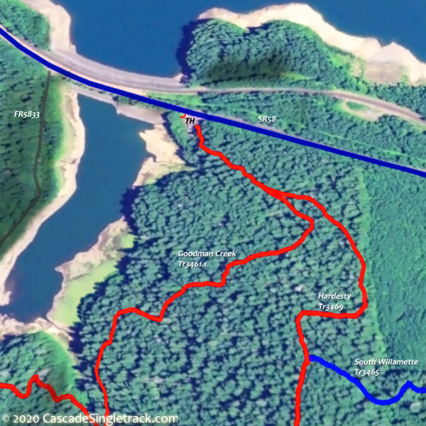
View of the Hardesty TH, ride to the Lawler Tr3473 TH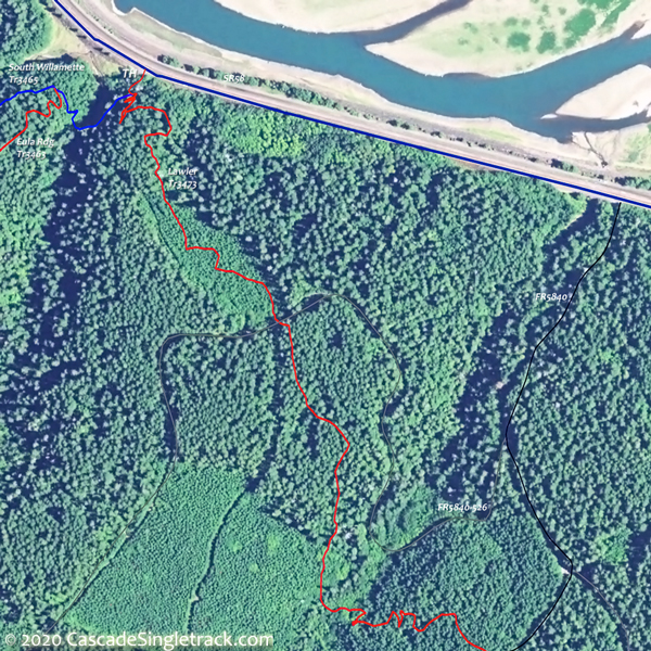
View of the Lawler, Eula Ridge TH and return. Maybe extend the ride with Goodman Creek Tr3461.1 or Lawler Tr3473 for a little more elevation or distance.
- 1mi: Cross Crale Creek, then cross FR5835 at 1.3mi. Cross FR806 and FR509 then ascend a moderate switchback to FR510 at 2.7mi, cresting the ride summit at 3mi.
- 3.5mi: Switchback descent to Harper Creek, then switchback ascend a minor ridge, followed by a descent to North Creek at 4.6mi, and merge with Eula Rdg Tr3463 at 4.8mi.


Trail Index
This Ride
Goodman Creek Trail 3461.1, Lawler Trail 3473, South Willamette Trail 3465
Area
Alpine Trail 3450, Clark Butte Trail 3456.1, Cloverpatch Trail 3457, Eagles Rest Trail 3461, Eugene to Pacific Crest Trail 3559, Eula Ridge Trail 3463, Hardesty Trail 3469, Hardesty Way Trail 1402, Jones Trail 3472, Larison Creek Trail 3646, Larison Rock Trail 3607, Lone Wolf-Patterson Mountain Trail 3470, Lost Creek Trail 3462, Middle Fork Willamette Trail 3609, North Fork Trail 3666, Sawtooth Trail 1401, Tire Mountain Trail 3485, Winberry Divide Trail 3476
Campgrounds
Black Canyon Campground, Shady Dell Campground
Trail Rankings
Ranking consistently applied to all of the listed trails.
- Overall Rating: Ride quality and challenge
- Aerobic: Ascent challenge
- Technical Difficulty: Terrain challenge
- Steepness: Average incline
- Flow: Uninterrupted riding
- Elevation Change: Total elevation gain
- Ride Difficulty: Terrain challenge
