
O'Leary Mountain Tr3321
Twitter Search
#OLearyTrailOR

Overall: 7
Aerobic: 9
Technical: 6
Steepness: 8
Flow: 5
Singletrack: 100%
The Paradise Oregon O'Leary Mountain Trail is a steep ridgeline ascent to MacDuff Mountain.
Type
Shuttle
Length
Avg: 12mi
Ascent
Intense
Elevation Change
TH:2250'
Avg Ascent:3400'
Ascent Incline
16%
Duration
Avg: 6hr
Weather
Forecast
NOAA
popup
USFS
Check forest service road conditions, as FR1993 access is affected by washouts and other damage and the upper TH may not be accessible by car. O'Leary Tr3321 can become overgrown when riders are not able to shuttle from the upper Olallie Tr3529 TH (due to FR1993 road closure).
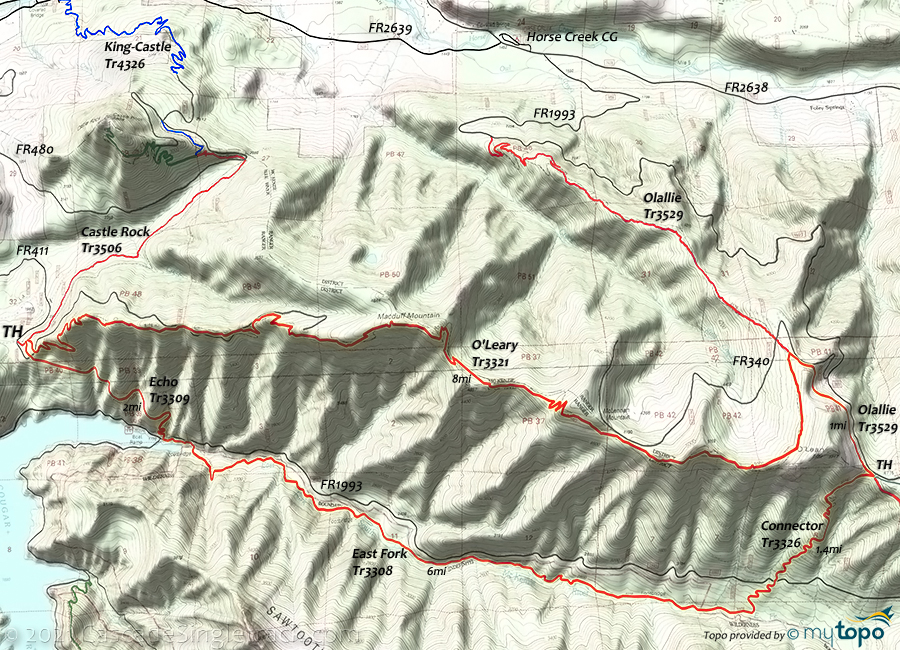
The O'Leary ridge trail traverses three mountain peaks: Mclennen, Macduff and O'Leary mountain, with a steep 4mi ascent between the TH and Mclennen mountain.
All of the trails to the east and south of FR1993 are in wilderness areas.
Too steep to be ridden OAB, from the FR411 trailhead O'Leary Tr3321 has a 4mi, 14% ascent to MacDuff Mountain. Ascending Olallie Tr3529 (or FR1993 if possible) to the upper O'Leary Tr3321 TH is the only reasonable option, making this a ride best left to shuttling.
O'Leary-Castle Epic
A 25.5mi (7500' ascent, all-day) epic CW loop starts at the King Castle Tr4326 TH and combines Olallie Tr3529, O'Leary Tr3321, Castle Rock Tr3506 and King Castle Tr4326.
With most of the climbing on FR2639 and FR1993, ascending a 1.5mi (10% grade) section of Olallie Tr3529 instead of continuing on FR1993 is manageable. Check on the FR1993 road condition, as it is prone to closures.
The 7mi (1900' ascent) FR2638-FR1993 road ride could be avoided with a shuttle, but is a reasonable ascent.

TH: From the King Castle Tr4326 TH, go east on FR2638 to the 3.8mi FR2639 intersection, then go right, to the 4.2mi FR1993 intersection.
4.2mi: Ascend FR1993, with an option to continue ascending FR1993 from the 7mi Olallie Tr3529 intersection to the upper FR1993 intersection. Do what you can.
10.4mi: If ascending Olallie Tr3529, then go right on O'Leary Tr3321 and enjoy the wild descent to the O'Leary TH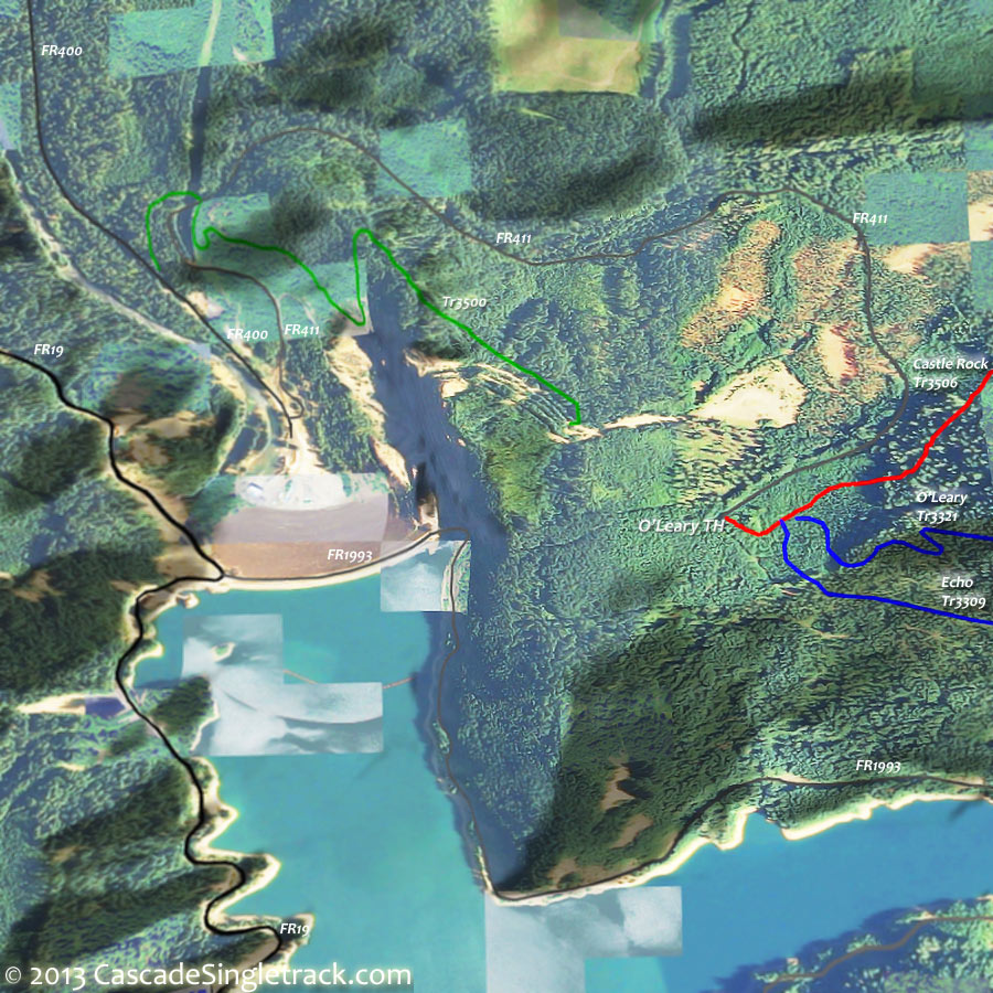
View of the O'Leary Trail 3321 TH.
18.5mi: Go right onto Castle Rock Tr3506, with a moderate descent to King Castle Tr4326, then a great downhill run to the TH.

Directions: SR126W to FR19 (Cougar Reservoir exit), then go 3.4mi to FR1993 and go across the reservoir dam. Go left on FR496 and then go to the O'Leary TH
O'Leary TH. View Larger Map. No Map?.

Shuttle Directions
the Olallie - O'Leary shuttle
- TH: From the Olallie Tr3529 TH, ascend the steep narrow hillside trail to the O'Leary Mountain Tr3321 intersection, crossing FR340 along the way.
- 3.6mi: Go right onto Olallie Tr3529 TH and cross the saddle to the O'Leary Mountain ridgeline (11.2mi). Pass Mclennan Mountain at 6mi and Macduff Mountain at 8mi..
- 8mi: Begin the increasingly steep, very fast switchback descent to the TH.

East Fork to O'Leary Hiking
East Fork Tr3308 is in the Three Sisters Wilderness Area and East Fork-Ollalie Connector Tr3326 is not suitable for biking, so this challenging CCW loop is best suited for hikers.
As a CCW loop, there is a 2mi, 16% ascent on the East Fork-Olallie Connector Tr3326.
- TH: From the O'Leary TH, ride Echo Tr3309 to FR1993 (1.9mi), then cross the road and ascend East Fork Tr3308, which follows the East Fork of the McKenzie River through a dense Douglas-fir forest.
- 7.9mi: Ascend to FR1993. Cross the road and continue the progressively steep East Fork-Ollalie Connector Tr3326 ascent to the Olallie Tr3529 intersection.
- 9.2mi: Go left at the Olallie Tr3529 intersection, paralleling FR1993 then a slow ascent to the ridgeline and the O'Leary Mountain Tr3321 intersection.
- 10.4mi: Go left onto O'Leary Mountain Tr3321 and cross the saddle to the O'Leary Mountain ridgeline (11.2mi). Pass Mclennan Mountain at 12.5mi and Macduff Mountain at 14.2mi.
- 14.5mi: Fast, switchback descent to the TH.

Nearby Walker Creek Tr3330 follows the Walker Creek drainage on an ascent to Lowder Mountain. The trail is infrequently maintained, so may be hard to follow at times, requiring backcountry navigation skills.
Lowder Mountain Tr3329 offers views of the French Pete drainage on the way to Yankee Mountain, descending 3900' in 4mi, past the old Tipsoo Butte lookout site through many steep switchbacks to Cougar Reservoir. Trail may be difficult to locate through the meadows area.
The 2mi Quaking Aspen Swamp Tr3332 is a nice short day hike, passing Quaking Aspen Swamp Botanical Area and Aspen Creek.
Trail Index
This Ride
Echo Trail 3309, Olallie Trail 3529, O'Leary Trail 3321
Area
Three Sisters Wilderness Hiking
East Fork Trail 3308, East Fork-Ollalie Connector Trail 3326, French Pete Creek Trail 3311, Lowder Mountain Trail 3329, Quaking Aspen Swamp Trail 3332, Walker Creek Trail 3330, Yankee Mountain Trail 3318
Campgrounds
Cougar Crossing Campground, Delta Campground, French Pete Creek Campground, Horse Creek Campground, Limberlost Campground, McKenzie Bridge Campground, Paradise Campground, Slide Creek Campground, Sunnyside Campground
Trail Rankings
Ranking consistently applied to all of the listed trails.
- Overall Rating: Ride quality and challenge
- Aerobic: Ascent challenge
- Technical Difficulty: Terrain challenge
- Steepness: Average incline
- Flow: Uninterrupted riding
- Elevation Change: Total elevation gain
- Ride Difficulty: Terrain challenge
