
McKenzie River: Trail Bridge CG to Clear Lake Tr3507
Twitter Search
#MckenzieRiverTrail

Overall: 9
Aerobic: 6
Technical: 6
Steepness: 5
Flow: 7
Singletrack: 100%
The combination of twisty riverside singletrack and moderate climbing makes Oregons McKenzie River Trail a favorite singletrack rides in the Cascade range.
Trail Bridge, Lakes End CG and Smith Reservoir (FR690, FR730, and FR689) Closed Through 2021 for power plant upgrades. See the NF Site for updates.
As always, it is best to call the local Ranger District for trail conditions and other restrictions prior to riding, as the NF website may not contain trip-specific details.
Type
OAB
Length
Avg: 17mi
Ascent
Moderate
Elevation Change
TH:2200'
Avg Ascent:2200'
Ascent Incline
4%
Duration
Avg: 3hr
Weather
Forecast
NOAA
popup
USFS
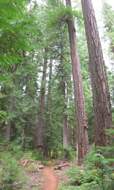
The combination of lava fields, footbridge crossings and the Sahalie waterfall climb keep things interesting. The moss-lined trail passes through old growth douglas fir.
To extend the McKenzie River Tr3507 ride, start from the Paradise CG TH. XC riders may prefer to shuttle from the upper Trailbridge CG TH to Paradise CG, to avoid the more technical northern trail conditions and the relatively flat southern section (past the Paradise CG).
To see the entire trail, check out the Topo Map of the entire McKenzie River Tr3507 ride. The map also shows some area non-wilderness hiking and the easily accessible Santiam Wagon Road Tr3413, a scenic wooded doubletrack trail which extends from Lebanon to the Deschutes NF. Portions of this trail are also well suited for novice bikers and family outings.
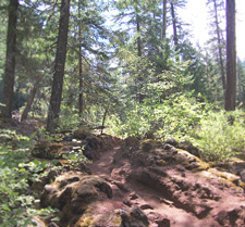
The lava fields are not as technical as they once were, but will still easily destroy pedals, deraileurs and skin if not respected. Not a good place to endo.
Heavy traffic appears to be making the trail between the lava section and the waterfalls more technical, as dirt and pumice packing reveals underlying rocks.
The trail has held up fairly well under heavy use and is best ridden during the week, to avoid collisions with hikers.
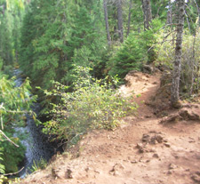
After the first few miles the hiker traffic thins out and there are long stretches of twisting, flowing singletrack.
The ride around Clear lake is less interesting and may include a lot of hikers from the campsites, but still worth checking out and a good way to extend the ride.
Area Campgrounds (north to south): Fish Lake CG, Cold Water Cove CG, Ice Cap Creek CG, Trail Bridge CG, Olallie CG, Limberlost CG, Paradise CG, McKenzie Bridge CG, Horse Creek CG.
Directions: From I-5N take highway 126 east 50 miles to the town of McKenzie Bridge, or from I-5S go through Sweet Home (avoiding the radar traps) to 126S. Go to the Trail Bridge Campground exit and turn right after crossing the bridge. Go up the dirt road .5mi to the TH. View Larger Map. No Map?.

OAB Directions
do the twist
- TH: The ride starts out fast and easy, winding alongside the McKenzie River and leading to the first of two lava sections.
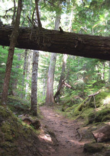
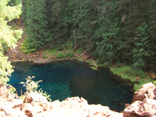
- 1.75mi: Reach Tamolich Falls and enjoy the scenic Tamolich blue pond. Pedestrian traffic drops off from this point northward, up to the Sahalie Falls area. Cross several footbridges and wind through dense forest and treefall.
- 4.7mi: Pass Carmen Reservoir then reach the intersection with pedestrian Waterfalls Loop Tr3503. Remain on the east side of the river and after another forest section, begin the Koosah to Sahalie Falls ascent.
- 6mi: After a series of ascents up to the top of Sahalie Falls, the trail descends to a footbridge and crosses to the west side of McKenzie River, then crosses SR126 and reaches Clear Lake and campground at 6.6mi. Go CW around the lake, with a few hike-a-bike lava sections and expect a lot of pedestrian traffic on the weekends.
- 10.7mi: Having circumnavigated Clear Lake, begin the fast descent back to the Trail Bridge campground TH. The Falls and lava sections may be too steep/technical for some riders, so be careful not to get out of control.


Trail Index
This Ride
Clear Lake Loop Trail 3507.2, McKenzie River Trail 3507
Area
Wilderness
Cedar Swamp Trail 3538, Gate Creek Trail 3412, Hackleman Old Growth Grove Trail 3411, Heart Lake Trail 3407, Horse Creek Trail 3514, Lowder Mountain Trail 3329, Olallie Park Trail 3530, Walker Creek Trail 3330, Waterfalls Loop Trail 3503
Mount Jefferson Wilderness Hiking
Big Meadow Tie Trail 3434, Blue Lake Trail 3422, Bowerman Lake Trail 3492, Clark Creek Nature Trail 3456, Dixie Trail 3494, Duffy Lake Trail 3427, Independence Rock Trail 3431, Lake of the Woods Trail 3493, Lava Trail 3433, Marion Trail 3436, Maxwell Butte Trail 3391, Minto Pass Trail 3437, Pine Ridge Trail 3443, Santiam Trail 3491, Santiam Lodge Trail 3496, Swallow Lake Trail 3488, Turpentine Trail 3490
Campgrounds
Cold Water Cove Campground, Fish Lake Campground, Ice Cap Creek Campground, Lakes End Campground, Lost Prairie Campground, Olallie Campground, Trail Bridge Campground
Trail Rankings
Ranking consistently applied to all of the listed trails.
- Overall Rating: Ride quality and challenge
- Aerobic: Ascent challenge
- Technical Difficulty: Terrain challenge
- Steepness: Average incline
- Flow: Uninterrupted riding
- Elevation Change: Total elevation gain
- Ride Difficulty: Terrain challenge
