
McKenzie River: Paradise CG to Trailbridge CG Tr3507
Twitter Search
#MckenzieRiverTrail

Overall: 8
Aerobic: 5
Technical: 4
Steepness: 3
Flow: 9
Singletrack: 100%
The Paradise Oregon McKenzie River Trail (from the Paradise Campground to the Trailbridge Campground) is a typical riverside ride, with moderate elevation gain along the way.
The Trail Bridge, Lakes End CG and Smith Reservoir (FR690, FR730, and FR689) Closed Through 2021 for power plant upgrades. See the NF Site for updates.
As always, it is best to call the local Ranger District for trail conditions and other restrictions prior to riding, as the NF website may not contain trip-specific details.
Type
OAB
Length
Avg: 26mi
Ascent
Easy
Elevation Change
TH:1400'
Avg Ascent:1700'
Ascent Incline
2%
Duration
Avg: 4hr
Weather
Forecast
NOAA
popup
USFS
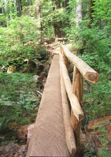
A typical campground trail, the southern section is popular with hikers. The terrain becomes increasingly challenging, especially when ridden OAB, as the trail traverses the hillside along the McKenzie River. The Trailbridge CG section is a cliffside traverse, requiring some technical skills and stamina.
The excitement starts just north of the Trailbridge CG, where the singletrack gets much more twisty, then comes the lava trails, then the waterfalls...
If camping in the area or for a relatively easy ride, this one is worth the effort.
Most of this ride is not easy enough for children and there are some brief ascents along the way, so please don't interpret the rating as indicating this is some city park trail.
Epic option: The OAB ride can be extended up to 45.7mi (4400' ascent, ~14hrs) by continuing the ride to Clear Lake.

To see the entire trail, check out the Topo Map of the entire McKenzie River Tr3507 ride. The map also shows some area non-wilderness hiking and the easily accessible Santiam Wagon Road Tr3413, a scenic wooded doubletrack trail which extends from Lebanon to the Deschutes NF. Portions of this trail are also well suited for novice bikers and family outings.
Mount Washington Wilderness Hiking

Advance reservations of Limited Entry Area permits for the very popular Obsidian Limited Entry Area are ONLY available through the National Recreation Reservation System (NRRS) at recreation.gov or by calling 1-877-444-6777. Season starts May 1st.
Starting in 2021, the Mt. Jefferson, Mt. Washington, and Three Sisters Wilderness Areas will require a Central Cascades Wilderness Permit for Day or Overnight use, from May 28th to Sept 24th.
Scott Tr3531 passes through moderately forested areas, over lava flows and alpine meadows, to Pacific Crest Tr2000-E.
Robinson Lake Tr3508 provides the western boundary of the popular Scott Mountain hiking system, passing through moderately forested, sub-alpine ecosystem, accessing Kuitan and Robinson Lakes.
Hand Lake Tr3513 and Benson Lake Tr3502 enable a variety of day hiking loops, with Scotty Way Tr4345 providing access to the Scott Mountain summit.
In the Three Sisters Wilderness Area, North Matthieu Lake Tr4062 is a segment of the Oregon Skyline Trail, replaced by the Pacific Crest Trail.
Directions: From I-5N take highway 126 east 50 miles to the town of McKenzie Bridge, or from I-5S go through Sweet Home (avoiding the radar traps) to 126S. Park at the ranger station or at the Paradise campground. View Larger Map. No Map?.

OAB Directions
fast river run
- TH: Ride alongside McKenzie River, past the Ranger Station and Paradise Campground (2.2mi). Pass spur Tr3541 at 3.7mi, then cross FR340 at 4.5mi and FR560 at 5.4mi.
- 6.15mi: After riding alongside SR126 for .1mi, cross the river, then reach FR2650 at 7.4mi and ride north for .3mi, then go right onto the singletrack again.
- 9.5mi: After crossing FR2654, use footbridge to cross Deer Creek.
- 12.6mi: Reach the southern end of Trail Bridge Reservoir. Continue riding north or turn around and go back to the Paradise TH.

Trail Index
This Ride
McKenzie River Trail 3507
Area
Box Canyon Trail 3660, Castle Rock Trail 3506, Chucksney Mountain Trail 3306, Clear Lake Loop Trail 3507.2, East Fork Trail 3308, East Fork-Olallie Connector Trail 3326, Echo Trail 3309, Grasshopper Mountain Trail 3569, Grasshopper Spur Trail 3314, King-Castle Trail 4326, McBee Trail 3523, Olallie Mountain Trail 4100, Olallie Trail 3529, O'Leary Trail 3321, Waterfalls Loop Trail 3503
Mount Washington Wilderness Hiking
Benson Lake Trail 3502, Deer Butte Trail 3508, Glacier Way Trail 4336, Hand Lake Trail 3513, Hand Lake Cuttoff Trail 4344, Linton Lake Trail 3519, Millican Crater Trail 4066, North Matthieu Lake Trail 4062, Obsidian Trail 3528, Pacific Crest Trail 2000-E, Proxy Falls Trail 3532, Robinson Lake Trail 4342, Scott Trail 3531, Scott Mountain Trail 4339 , Scott Obsidian Tie Trail 3531.1, Scotty Way Trail 4345, Tenas Lakes Trail 4340
Campgrounds
Alder Springs Campground, Camp Melakwa, Frog Camp, Horse Creek Campground, Limberlost Campground, McKenzie Bridge Campground, Lava Campground, Olallie Campground, Paradise Campground, Scott Lake Campground, Viewpoint Campground
Trail Rankings
Ranking consistently applied to all of the listed trails.
- Overall Rating: Ride quality and challenge
- Aerobic: Ascent challenge
- Technical Difficulty: Terrain challenge
- Steepness: Average incline
- Flow: Uninterrupted riding
- Elevation Change: Total elevation gain
- Ride Difficulty: Terrain challenge
