
Middle Fork Willamette Tr3609
Twitter Search
#WillametteRiverTrail

Overall: 6
Aerobic: 4
Technical: 4
Steepness: 3
Flow: 8
Singletrack: 100%
The Oakridge Oregon Middle Fork Willamette Trail is a fast river ride, but at 33mi, it is long enough to split up into several rides.
Type
OAB
Length
Avg: 20.5mi
Ascent
Easy
Elevation Change
TH:1550'
Avg Ascent:1900'
Ascent Incline
3%
Duration
Avg: 3hr
Weather
Forecast
NOAA
popup
USFS
As with any river ride, expect some sections to be washed out, especially in the Spring. As of July 2012 the section between Indigo Springs intersection and FR393 was washed out and unrideable. The Paddy's Valley burn area is also prone to trail damage so be sure to check with the forest service or local bike shops to get the current trail condition.
The trail crosses many unbridged creeks which feed the Middle Fork Willamette, so this a dry weather, summertime ride.
The first 20mi are at an easy 3% grade, with a lot of hillside traverse and some pathfinding may be needed.
FR21 and the local fireroads can serve as connectors for any washed out sections.
The Sand Prairie campground to Campers Flat campground section is the most popular and best suited for those seeking an easier river ride. The Campers Flat CG to Sacandaga CG section is a technical intermediate ride.
Campers Flat to Indigo Springs OAB


The next 10mi of the trail extends the ride to Indigo Springs campground, but is more likely to experience springtime trail damage.
This section of the trail includes a minor ascent near Sanadaga campground, but is otherwise still about a 3% grade.
In addition to ascending from the Indigo campground to Indigo Lake, nearby Youngs Rock Tr3685 can be added to the first section of Middle Fork Willamette Tr3609, into one tough lollipop ride.
Those seeking a more challenging river ride could look south, to the Umpqua River Trail Dread and Terror segment.
To the north, the Bunch Grass Tr3559 section of the Eugene to Crest Trail offers a similarly long ridgeline ride option.

Indigo Springs to Indigo Lake OAB
The 12.5mi section from Indigo Springs campground to Indigo Lake is more challenging, with 7mi of 4% grade followed by a 5.5mi ascent to Timpanogas Lake, then to Indigo Lake, over an 8% to 10% grade. Of course, FR2154 also makes this a perfect shuttle opportunity..

Directions: See Map. View Larger Map. No Map?.

OAB Directions
Sand Prairie to Campers Flat OAB
Middle Fork Willamette Area Topo Map
- TH: Ride from the south end of the Sand Prairie campground to the gate, then continue on FR017 to the trail (bear right). Cross FR016, then cross the Buck Creek bridge at .6mi. Go around a bend, ride alongside Cone Creek, then cross FR151 at 1.7mi.
- 2.6mi: Cross FR156, then bear left, cross Estep Falls Creek, then approach FR21 several times over the next .5mi. Ride alongside then cross Pine Creek, then cross FR022 at 3.9mi.
- 5.2mi: Ride alongside FR21 then ride across the river on FR2127. Parallel FR2125 while crossing FR029, then cross FR032 at 5.9mi.
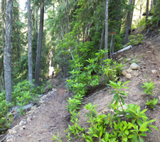
- 6mi: The next 2mi of the trail is a little more technical, clinging to the hillside next to the river, with some short climbs over rocky and rooty terrain. Pass Secret campground (across the river) at 7.6mi, just after crossing Indian Creek.
- 9.2mi: Cross Coal Creek, then turn around at FR2133 at 9.4mi, with an option of taking on Youngs Rock Tr3685 or more of Middle Fork Willamette Tr3609.

Trail Index
This Ride
Middle Fork Willamette Trail 3609
Area
Alpine Trail 3450, Aubrey Mountain Trail 3554, Box Canyon Trail 3660, Bunch Grass Trail 3559, Chucksney Mountain Trail 3306, Cloverpatch Trail 3457, Deception Butte Trail 3466, Eagles Rest Trail 3461, Eugene to Pacific Crest Trail 3559, Eula Ridge Trail 3463, Goodman Creek Trail 3461.1, Grasshopper Mountain Trail 3569, Grasshopper Spur Trail 3314, Hardesty Trail 3469, Hardesty Way Trail 1402, Larison Creek Trail 3646, Larison Rock Trail 3607, Lawler Trail 3473, Lone Wolf-Patterson Mountain Trail 3470, Lost Creek Trail 3462, Mayflower Loop Trail 1559, McBee Trail 3523, Moon Point Trail 3688, Mount June Trail 1400, North Fork Trail 3666, Salmon Creek Trail 4233, Sawtooth Trail 1401, South Willamette Trail 3465, Tire Mountain Trail 3485, Winberry Divide Trail 3476, Windy Pass Trail 3643, Youngs Rock Trail 3685
Waldo Lake
Betty Lake Trail 3664, Bobby Lake Trail 3663, Douglas Horse Pasture Trail 4382, Fuji Mountain Trail 3674, Gold Lake Trail 3677, Maiden Lake Trail 41, Maiden Peak Trail 3681, Metolius-Windigo Trail 99, Moore Creek Trail 3840, Mount Ray Trail 2682, South Waldo Lake Trail 3586, The Twins Trail 3595, Waldo Lake Trail 3590
Hiking
Indigo Lake Trail 3649, June Lake Trail 3639, Start O Willamette Trail 3642, Timpanogas Lake Trail 3638
Campgrounds
Campers Flat Campground, Indigo Springs Campground, Sacandaga Campground, Sand Prairie Campground, Secret Campground, Timpanogas Campground
Trail Rankings
Ranking consistently applied to all of the listed trails.
- Overall Rating: Ride quality and challenge
- Aerobic: Ascent challenge
- Technical Difficulty: Terrain challenge
- Steepness: Average incline
- Flow: Uninterrupted riding
- Elevation Change: Total elevation gain
- Ride Difficulty: Terrain challenge
