
Lost Creek Trail 3462 and Sawtooth Trail 1401 Area Mountain Biking and Hiking Topo Map
Map includes: Eagles Rest Trail 3461, Eula Ridge Trail 3463, Goodman Creek Trail 3461.1, Hardesty Trail 3469, Hardesty Way Trail 1402, Lost Creek Trail 3462, Mount June Trail 1400, Sawtooth Trail 1401 and South Willamette Trail 3465 Mountain Biking and Hiking Trails.
Lost Creek, Mount June, Hardesty Way, Sawtooth OAB
TH: From the FR511 Lost Creek TH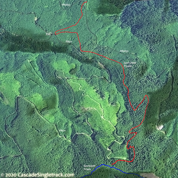
View of the Lost Creek TH, ascend 1400' on Lost Creek Tr3462.
2.7mi: Go right on Sawtooth Tr1401, then climb Mount June Tr1400, reaching the ride summit at 3.3mi. Return to Sawtooth Tr1401, passing the Lost Creek Tr3462 intersection on the left at 4.4mi, then continuing to Hardesty Way Tr1402.
5.3mi: Go right onto Hardesty Way Tr1402 and ride OAB to FR161, then return to Sawtooth Tr1401 and go right and ride to the FR550 TH.
11.6mi: From the Sawtooth Tr1401 FR550 TH, pass the Hardesty Tr3469 intersection on the right at 12.2mi, with an option to ride Hardesty Tr3469 OAB 1.2mi. Return on Sawtooth Tr1401 to Lost Creek Tr3462.
14.7mi: Go right on Lost Creek Tr3462 and return to TH.


Draggable map: Map window adjusts to screen size and will respond to touch control. Use scrollbar for mouse control.
No Map? Browser settings and some browser extensions can prevent the maps from appearing. Please see Site Tech

