
Alpine Tr3450
Twitter Search
#AlpineTrailOR

Overall: 10
Aerobic: 8
Technical: 7
Steepness: 7
Flow: 7
Singletrack: 50%
There are several ways to experience the epic Oakridge Oregon Alpine ridgeline trail, depending on ride and climbing preferences. Ascending FR1910 to create an Alpine loop may not seem very epic to some people.
Type
Loop
Length
Avg: 19.5mi
Ascent
Moderate
Elevation Change
TH:1200'
Avg Ascent:5600'
Ascent Incline
11%
Duration
Avg: 5hr
Weather
Forecast
NOAA
popup
USFS

The southern Alpine terrain is also part of the Tire Mtn Tr3485 and Cloverpatch Tr3457 CCW Loop.
Forest roads create mid and northern Alpine Tr3450 access points.
The initial 1mi ascent is a 19% grade (followed by a 10% incline over 5.5mi), but strong climbers might be able to hike-a-bike the first mile and climb the rest. Beware: Consider that virtually all of the traffic flow is North to South, and that the steepest sections of the trail have loose conditions due to all the high speed downhill traffic.
From the west, Alpine Tr3450 can also be accessed from the 3.5mi (17% ascent) Gold Point Tr3468, although that approach is too steep for most riders.
FR5828 OAB: A better OAB option is to drive 1.6mi from the Alpine North Fork TH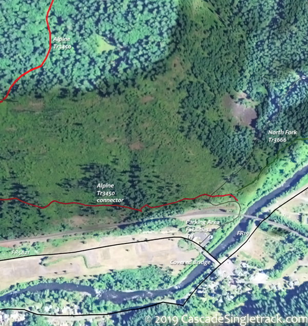
View of the Alpine North Fork TH, towards Lookout Point Lake on FR5821, then go right on FR5828 for 3.8mi. This avoids the last 1.5mi of Alpine Tr3450, resulting in a 37.5mi (9700' ascent) epic OAB ride.

Northern approach: A moderate 29mi (7200' ascent) OAB option is to start from the Alpine FR1835 TH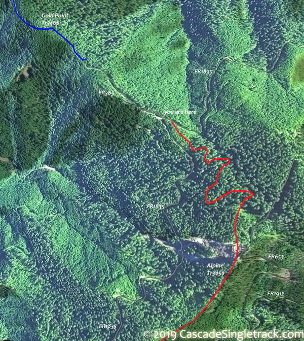
View of the Alpine FR1835 TH, using FR18/FR1835, with a Windy Pass or Tire Mountain Tr3485 intersection turnaround (just prior to the southern descent).

The steepest incline is 7%, on the Sourgrass Mountain ascent from MP5 to MP9.
FR1910-Alpine CCW Loop: Although a popular loop option, the FR1910 8mi road climb option involves climbing 4500' over an uneven 10% grade, and so is not much easier than simply climbing/hiking Alpine.
Directions: See Map. View Larger Map. No Map?.


Loop Directions
FR1910 road climb

- TH: From the FR5821 parking area, cross the covered bridge and go left on FR19 to FR1910. North Fork Tr3666 is designated hiker-only.
- 2.8mi: Go left onto FR1910 and climb 8mi to Alpine Tr3450 at Windy Pass. Option: continue 3.2mi on FR1912 from Windy Pass to the TH which is just north of Sourgrass Mountain.
- 8.1mi: Bear right at the FR683 intersection.
- 10.7mi: Go left onto Alpine Tr3450.
- 12.1mi: Tire Mountain Tr3485 intersection.
- 13.6mi: Cross FR683 and pass the Buckhead Shelter on the left.
- 15.6mi: Trail parallels then crosses FR5828.
- 17.9mi: Partway down the steep descent to FR5821, go sharply back to the left on the connector trail, which leads back to North Fork Tr3666, then back to the TH.


Trail Index
This Ride
Alpine Trail 3450, Gold Point Trail 3468
Area
Aubrey Mountain Trail 3554, Box Canyon Trail 3660, Bunch Grass Trail 3559, Chucksney Mountain Trail 3306, Clark Butte Trail 3456.1, Cloverpatch Trail 3457, Deception Butte Trail 3466, Eagles Rest Trail 3461, Eugene to Pacific Crest Trail 3559, Eula Ridge Trail 3463, Goodman Creek Trail 3461.1, Grasshopper Mountain Trail 3569, Grasshopper Spur Trail 3314, Hardesty Trail 3469, Hardesty Way Trail 1402, Jones Trail 3472, Larison Creek Trail 3646, Larison Rock Trail 3607, Lawler Trail 3473, Lone Wolf-Patterson Mountain Trail 3470, Lost Creek Trail 3462, McBee Trail 3523, Middle Fork Willamette Trail 3609, Mount June Trail 1400, Salmon Creek Trail 4233, Sawtooth Trail 1401, South Willamette Trail 3465, Tire Mountain Trail 3485, Winberry Divide Trail 3476
Waldo Lake
Betty Lake Trail 3664, Bobby Lake Trail 3663, Douglas Horse Pasture Trail 4382, Fuji Mountain Trail 3674, Gold Lake Trail 3677, Maiden Lake Trail 41, Maiden Peak Trail 3681, Metolius-Windigo Trail 99, Moore Creek Trail 3840, Mount Ray Trail 2682, South Waldo Lake Trail 3586, The Twins Trail 3595, Waldo Lake Trail 3590
Hiking
North Fork Trail 3666, Saddleblanket Tr3487
Campgrounds
Black Canyon Campground, Shady Dell Campground
Trail Rankings
Ranking consistently applied to all of the listed trails.
- Overall Rating: Ride quality and challenge
- Aerobic: Ascent challenge
- Technical Difficulty: Terrain challenge
- Steepness: Average incline
- Flow: Uninterrupted riding
- Elevation Change: Total elevation gain
- Ride Difficulty: Terrain challenge
