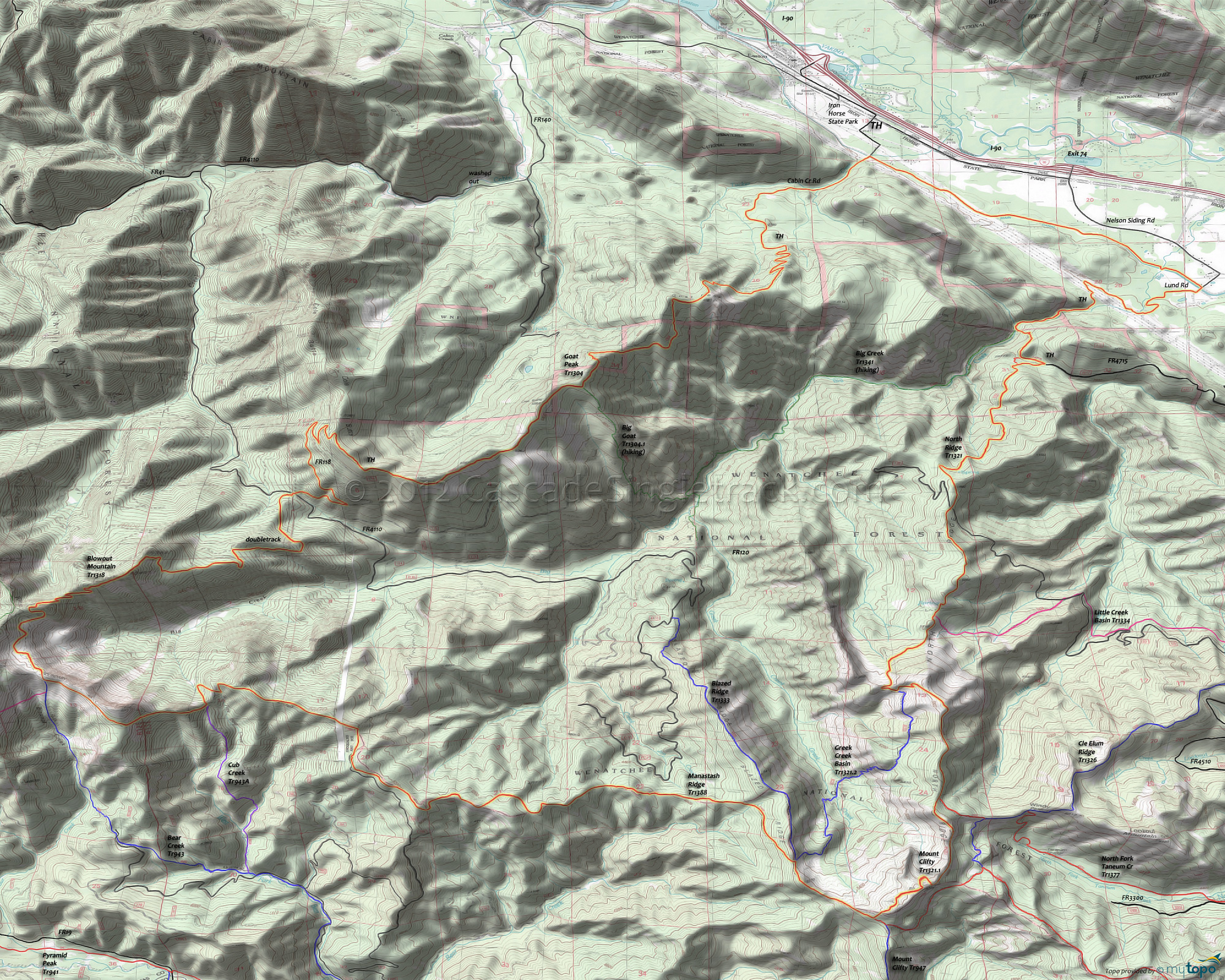
Blowout Mountain Trail 1318, North Ridge Trail 1321 and Goat Peak Trail 1304 Area Mountain Biking and Hiking Topo Map
Map includes: Big Creek Trail 1341, Big Goat Trail 1304.1, Blazed Ridge Trail 1333, Blowout Mountain Trail 1318, North Ridge Trail 1321, Goat Peak Trail 1304, Granite Creek Trail 1326.1, Greek Creek Basin Trail 1321.2 and Mount Clifty Trail 1321.1 Mountain Biking and Hiking Trails.
TH: Park at Iron Horse state park, then ride alongside the canal on Filbert Rd., to Lund Rd (under the powerlines), to the Big Creek Tr1341 access trail TH.
5.6mi: Ride the access trail to North Ridge Tr1321 and traverse the steep Big Creek drainage to the ridgeline. This section of the trail will prove if this ride was a good idea or not.
9.3mi: Reach the ridgeline, then cross FR120 at 9.5mi before resuming the North Ridge ascent. Pass the Greek Creek Basin Tr1321.2 intersection on the right at 11.8mi, a trail which traverses the 1000' deep Greek Creek drainage.
13.3mi: After reaching a ridgeline peak at 12.3mi, go right onto Mount Clifty Tr1321.1 and ride the rough terrain around the Mount Clifty summit.
15mi: Go right onto Manastash Ridge Tr1388, which drops off the ridgeline at the 15.8mi Mount Clifty Tr1321.1 intersection. The descend ends at 17mi, followed by a section of gradually ascending rough trail. The extensive Orv use makes portions of this section hike-a-bike.
20.2mi: Pass the FR780 intersection on the left. The trail detours steeply off then back onto the ridgeline, just prior to passing the Cub Creek Tr943A intersection on the left at 22.2mi.
23.5mi: At the Bear Creek Tr943 intersection, go right onto Blowout Mountain Tr1318. Snake along the ridgeline to the doubletrack at 26.3mi, then descend the steep access road to FR4110.
28.2mi: At FR4110, cross the road and bear to the right onto FR118, climbing back out of the valley. Follow the topo and certainly use a gps, as there are a number of spur trails in the area.
31mi: Go on Goat Peak Tr1304 at the end of the doubletrack, passing the Cole Butte summit at 32.6mi and passing the Big Goat Tr1304.1 intersection at 33mi. Drop off the ridgeline in some tight switchbacks to a saddle, then climb past the Goat Peak summit at 34.8mi.
36.7mi: After a steep, switchback descent from Goat Peak, reach Cabin Creek Rd and go left, following the Tucker Creek drainage back to the Iron Horse SP TH.
Draggable map: Map window adjusts to screen size and will respond to touch control. Use scrollbar for mouse control.
No Map? Browser settings and some browser extensions can prevent the maps from appearing. Please see Site Tech


