
Boulder De Roux Trail 1392 Area Mountain Biking and Hiking Topo Map
Map includes: Boulder De Roux Trail 1392, Hawkins Mountain Trail 1228, Camp Creek Trail 1208, Camp Creek Mine Trail 1208.1, Elsnor Mine Trail 1392.8, Paris Creek Trail 1393.1 Mountain Biking and Hiking Trails.
TH: Ride from the Camp Creek TH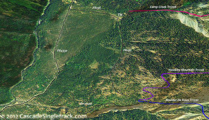
View of the Boulder De Roux,Camp Creek,Hawkins Mountain TH .9mi to Boulder De Roux Tr1392 and begin the rugged ascent, with creek crossings at 1.9mi, 2.3mi, 2.5mi and 3mi. Pass the South Fork Boulder Tr1392.7 intersection on the right at 2.7mi, followed by a creek crossing, then pass the Elsnor Mine Tr1392.8 intersection on the right at 3.2mi.
4.1mi: Climb out of the Big Boulder Creek drainage at 3.5mi then reach FR301, go left and continue ascending to FR304, which is just past where the Boulder De Roux Tr1392 singletrack resumes (on the right side of the road, towards the De Roux Creek drainage).
4.7mi: Go left onto FR304, cross Big Boulder Creek, and ride to the end of the wide dirt road, onto Camp Creek Mine Tr1208.1 at 6.1mi.
6.6mi: At the 4-way Hawkins Mountain Summit intersection, which is also the ride summit, go left onto Hawkins Mountain Tr1228 and descend the very steep trail to Camp Creek Tr1208.
7mi: Go right onto Camp Creek Tr1208, or continue on Hawkins Mountain Tr1228 if able to handle the extreme terrain which it covers. Cross Camp Creek at 7.5mi, then begin the switchback descent at 8.2mi, to the TH.

Draggable map: Map window adjusts to screen size and will respond to touch control. Use scrollbar for mouse control.
No Map? Browser settings and some browser extensions can prevent the maps from appearing. Please see Site Tech

