Rock Creek to Basalt Ridge Tr1515

Overall: 8
Aerobic: 8
Technical: 7
Steepness: 8
Flow: 7
Singletrack: 100%
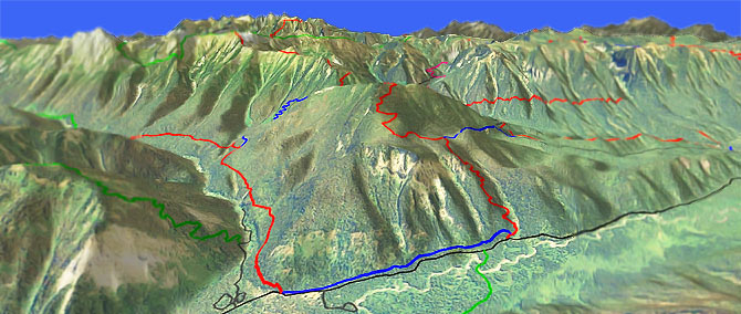
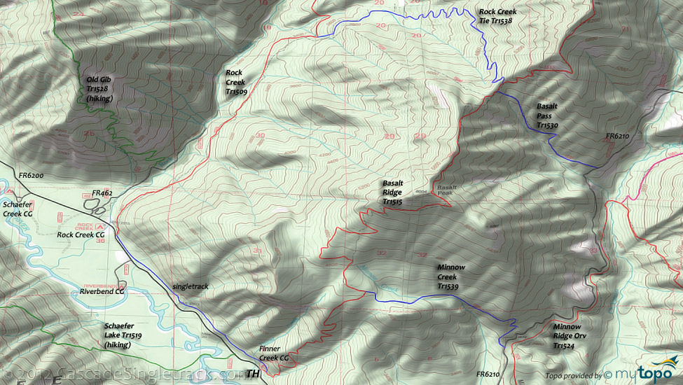
Ascend Rock Creek Tr1509 to Rock Creek Tie Tr1538, followed by a swooping descent on Basalt Ridge Tr1515.
Type
Loop
Length
Avg: 11.5mi
Ascent
Mt Goat
Elevation Change
TH:2450'
Avg Ascent:4500'
Ascent Incline
14%
Duration
Avg: 4hr
Weather
Forecast
NOAA
popup
USFS
Trail
Review
The toughest ascent of the ride is on the 2.4mi (1800', 14% grade) Rock Creek Tie Tr1538, although the switchbacks are mostly rideable.
The Lake Wenatchee washington Basalt Ridge Trail can also be accessed from Minnow Ridge Orv Tr1524 or FR6210, using Minnow Creek Tr1539 (1000', 13% ascent) and Basalt Pass Tr1530 (1300', 25% ascent) to form an 8mi (3600' ascent) advanced-skills CW loop.
Add Chikamin Creek Orv Tr1534 to create a near-epic 18mi (6900' ascent) excursion, possibly the best area ride.
As with all trails where it is possible, please sign in at the trailhead, to help let the forest service know that mountainbikers are using the trail.
Ding: Although Orv are prohibited on these trails, mountainbikers are infrequent users as well, so the trail can become overgrown in late summer and maintenance can be as infrequent as well.
Wilderness Hiking: Rock Creek ascends to the base of Carne Mountain, with several great hiking trails in the Glacier Peak Wilderness Area.
Old Gib Tr1528 offers a rugged ridgeline route, over Estes Butte and Old Gib Mountain, to Carne Mountain.
The hike can be extended with Leroy Creek High Route Tr1512 and FR6200 is well suited for shuttling.
FR6200 Camping: (listed from north to south) Phelps Creek CG, Alpine Meadows CG, Nineteenmile CG, Atkinson Flat CG, Schaefer Creek CG, Rock Creek CG, Riverbend CG, Huckleberry Ford CG, Grouse Creek CG, Meadow Creek CG.
Directions: NW Forest Pass required right at the TH. SR207 to Lake Wenatchee, then cross the Wenatchee River, then bear right onto Chiwawa Loop Road. Go for 1.3mi, then turn left on FR62/SR3 (Chiwawa River Rd). Go for 11.1mi, then continue on gravel road for another 4mi. Go past the Basalt Ridge TH to the Finner Creek campground or Rock Creek campground TH. View Larger Map. No Map?.

Loop Directions
top of the world
- TH: From the Finner Creek campground, ride FR6200 or the Finner Creek Tie trail towards the Rock Creek campground. Cross Finner Creek and several other creeks.
- 1.7mi: Just prior to reaching the Rock Creek campground, go right onto Rock Creek Tr1509 and ascend alongside Rock Creek, crossing 4 creeks prior to reaching the Rock Creek Tie Tr1538 intersection. Traverse the steep hillside for 1mi, then settle into a steady ascent to the next crest, at 3.7mi, crossing 3 steep creek drainages along the way.
- 4.1mi: Just prior to the 4th creek crossing, reach the Rock Creek Tie Tr1538 intersection and go right (intersection is marked with a tree marker, if you can find it..). Ascend 1800' in 2.4mi over increasingly tougher terrain. The trail is smooth but there is a traverse at 5.6mi which is followed by 5 tough switchbacks (13 switchbacks total), which will require some hike-a-bike for intermediate riders.
- 6.6mi: At the saddle intersection, go right onto Basalt Ridge Tr1515 and immediately pass the Basalt Pass Tr1530 intersection on the left. Hike-a-bike .3mi out of the saddle, with 2 more .3mi climbs to reach Basalt Peak (more hike than bike). Ascend the increasingly exposed and rocky terrain, requiring some technical skills and likely to be hike-a-bike for intermediate riders, before reaching the 7.7mi Basalt Peak ride summit. There is a summit viewpoint to the right, with Basalt Ridge Tr1515 bearing to the left. View Shaefer Lake, the White Mountains and Glacier Peak Wilderness from this amazing vista, then prepare for some relentless downhill.
- 9.8mi: After a steep, wide-open switchback descent, pass the Minnow Creek Tr1539 intersection on the left, with a viewpoint trail on the right. Descend the final 1.5mi to the TH over relatively smooth but very steep switchback terrain.
Trail Index
This Ride
Basalt Pass Trail 1530, Basalt Ridge Trail 1515, Minnow Creek Trail 1539, Rock Creek Trail 1509, Rock Creek Tie Trail 1538
Area
Wilderness
Carne Mountain Trail 1508, Estes Butte Trail 1527, Garland Peak Trail 1408, Leroy Creek High Route Trail 1512, Phelps Creek Trail 1511, Old Gib Trail 1528, Schaefer Lake Trail 1519
Campgrounds
Finner Creek Campground, Riverbend Campground, Rock Creek Campground
Trail Rankings
Ranking consistently applied to all of the listed trails.
- Overall Rating: Ride quality and challenge
- Aerobic: Ascent challenge
- Technical Difficulty: Terrain challenge
- Steepness: Average incline
- Flow: Uninterrupted riding
- Elevation Change: Total elevation gain
- Ride Difficulty: Terrain challenge


