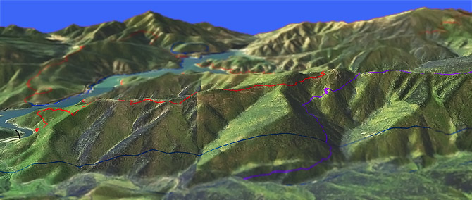
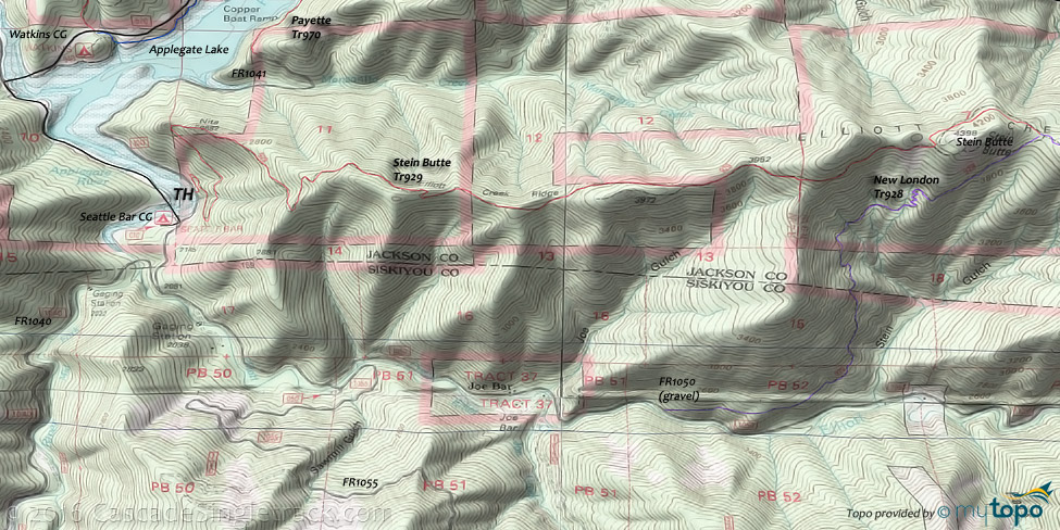
Stein Butte Tr929
Twitter Search
#steinbuttetrail

Overall: 7
Aerobic: 7
Technical: 6
Steepness: 6
Flow: 7
Singletrack: 80%
The Applegate Lake Oregon Stein Butte Tr929 can be combined with New London Tr928 for a solid OAB or CW loop ride, or use Carlton Pasture Tr930 and FR1050 for an extended CW loop.
Type
Loop
Length
Avg: 19mi
Ascent
Intense
Elevation Change
TH:2100'
Avg Ascent:6700'
Ascent Incline
13%
Duration
Avg: 4hr
Weather
Forecast
NOAA
popup
USFS
Stein Butte named after a prospector who mined in this vicinity during the early gold rush years of the 1850s and 1860s. Past hydraulic, surface and lode mining activity can be seen along the trail.
The shortest (9.8mi, 4200' ascent) loop is Stein Butte Tr929 to New London Tr928, returning on FR1050.
Over a 1000' of the ascent is on FR1050 (due to uneven terrain), when a ridge return is entirely rideable.
Returning on FR1050 wastes the effort of the 13% Stein Butte Tr929 ascent, and extending the ride to Carlton Pasture Tr930 and returning on FR1050 is even tougher, resulting in 2000' of road ascent.
Considering the length of the FR return, the best ride (as described in the guide below) may be a 19mi OAB to the end of New London Tr928, which has 6700' of climbing (1500' of which is due to uneven terrain and not steady climbing).
The Oaks Flats trail, shown beyond Carlton Pasture Tr930, may not be rideable.
The longest loop (CCW, 23mi, 7700' climbing) involves riding the entire length of New London Tr928 (also known as Elliot Rdg Tr) out to Summit Lake Tr926, then a 5mi return on FR1075 to Payette Tr970 and a lakeside cruise back to the TH.
Carlton Pasture Tr930 is a steep switchback through a mixed conifer and hardwood forest.
Directions: At the south lake shore on Co. Rd 859, go left at the Carberry Cr. Rd. "T" and continue for 1mi. Cross the bridge and park in the gravel lot on the left. View Larger Map. No Map?.

Loop Directions
no FR req'd
- TH: Ascend Elliot Ridge 4mi to the Stein Butte summit.
- 6.3mi: Trail merges with ridgeline doubletrack FR550, near Mingo Gap. Go straight at 7mi, onto FR500, then ascend from Carlton peak to Prospect peak.
- 9.1mi: Pass trail on the left, then reach the Carlton Pasture Tr930 intersection, near Summit Lake at 9.6mi. Return to the TH, or extend the ride.
Trail Index
This Ride
Carlton Pasture Trail 930, New London Trail 928, Stein Butte Trail 929, Summit Lake Trail 926
Area
Hiking
Harr Ridge Trail 947, Little Squaw Trail 923, Squaw Lakes E Trail 925
Campgrounds
Carberry Campground, Flumet Flat Campground, French Gulch Campground, Harr Point Campground, Hart-Tish Campground, Jackson Campground, Latgawa Cove Campground, Seattle Bar Campground, Squaw Lakes Campground, Tipsu Tyee Campground, Watkins Campground
Trail Rankings
Ranking consistently applied to all of the listed trails.
- Overall Rating: Ride quality and challenge
- Aerobic: Ascent challenge
- Technical Difficulty: Terrain challenge
- Steepness: Average incline
- Flow: Uninterrupted riding
- Elevation Change: Total elevation gain
- Ride Difficulty: Terrain challenge


