Wynoochee Lake Tr878
Twitter Search
#wynoochee

Overall: 5
Aerobic: 4
Technical: 3
Steepness: 4
Flow: 8
Singletrack: 100%
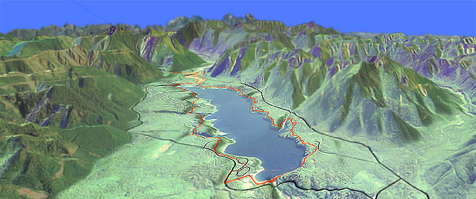
The Aberdeen Washington Wynoochee Lake Trail begins at the north end of Coho CG and travels around the lake through second growth forest.
Type
Loop
Length
Avg: 15mi
Ascent
Easy
Elevation Change
TH:900'
Avg Ascent:2000'
Ascent Incline
4%
Duration
Avg: 2hr
Weather
Forecast
NOAA
popup
USFS
Trail
Review
Typical of most lakeside rides, expect some brief 50' - 100' climbs, which helps keep the ride interesting.
Wynoochee Lake Tr878 is shown as a CW ride, but CCW is fine as well.
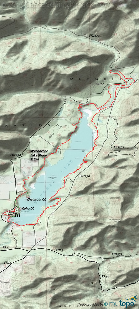
Some of the many creek and access road crossings are noted on the profile map.
Nearby West Fork Humptulips Tr806 is open to biking, but is rarely ridden due to relentless river crossings.
Not a destination trail, the 21mi (2100' ascent) West Fork Humptulips Tr806 OAB to Campbell Tree Grove CG might be worth trying if camping in the area, but otherwise is more suitable for hiking.
The 1mi Lower Petes Creek Tr858.1 is also open to biking but far too short to be of any use other than as something to explore from the Campbell Tree Grove CG.
Olympic National Park Hiking
The National Park includes most of the National Forest, with some wilderness areas at the periphery.
Expect a lot of summer hiking traffic in the Lake Quinalt area trails. Go further north (into the park) to escape the crowds.
Always carry the 10 Essentials: map, compass, flashlight, knife, matches, nylon cord, extra food and water, and rain gear with warm clothes.
The ONP site offers current wilderness trail conditions and map.
For ONP camping permits, go to the Wilderness Information Center (WIC) in Port Angeles. No reservations necessary.
Directions: Go 35mi west of Montesano on Wynoochee Valley Rd, which turns into FR22. At the intersection, go left to stay on FR22, then go right on FR2294 and continue for 1mi to the Coho CG. View Larger Map. No Map?.

Loop Directions
lake loop
- TH: Ride north from the Coho campground, crossing FR240 at .5mi, near the Chetwoot campground. Cross Scatter Creek at 1mi and an unnamed creek at 1.9mi.
- 2.2mi: Merge with FR360 for .2mi then traverse the hillside in the first of four ascents. Cross a small creek at 3.3mi, descend to the lakeside, then ascend the hill for the Trout Creek crossing at 4.3mi.
- 4.8mi: Approach the Wynoochee River, with an option to cross it and head back to the TH. Go left and ride alongside the river, prior to climbing to the Eleanor Creek crossing at the 6.7mi ride summit.
- 7.2mi: Cross the Wynoochee River on FR2270, then rejoin the trail and descend gentle terrain alongside the river, crossing FR181 at 9.4mi.
- 11.7mi: After crossing several creeks and riding at the shoreline, cross FR140. Ascend a cove and cross Sixteen Creek at 12.5mi. Approach FR100 at 13.7mi.
- 14.2mi: Pass a campground then cross Wynoochee Dam and return to the TH.
Trail Index
This Ride
Wynoochee Lake Shore Trail 878
Area
Church Creek Trail 871, Dry Creek Trail 872, Gold Creek Trail 830, Lower Dungeness Trail 833, Lower Pete's Creek Trail 858.1, Lower South Fork Skokomish Trail 873, West Fork Humptulips Trail 806
Green Mountain SF
Beaver Pond Trail, Dry Creek Trail 872, Gold Creek Trail, Pine Lake Trail 887.1, Plummer Trail, Tin Mine Trail, Vista Trail, Wildcat Trail
Tahuya SF
1.9 Mile Trail, Deraileur 2 Trail, Hoof and Tail Trail, Howell Lake Trail, JBxR Trail, Mission Creek Trail, Noble Trail, Northwest Passage Trail, Nucleus Trail, Overland Trail, Rail's Grade Trail, Raines Grade Trail, Randy's H2O Stop Trail, Road Apple Trail, Salmon Trail, Sims Trail, Stoffer Trail, Tayuha River Trail, Tommy Trail, Twin Lakes Trail, UB Lost Trail
Olympic NF Hiking
Colonel Bob Trail 851, Fletcher Canyon Trail 857, Graves Creek Primitive Trail 874, Pete's Creek Trail 858
Olympic NP Wilderness Hiking
Big Creek Trail, Elip Creek Trail, Finley Peak Route, Irely Lake Trail, Martins Park Primitive Trail, North Fork Quinault River Trail, Rustler Creek Route, Skyline Trail
NF Campgrounds
Campbell Tree Grove Campground, Chetwoot Campground, Coho Campground, North Fork Campground, Wynoochee Falls Campground
Trail Rankings
Ranking consistently applied to all of the listed trails.
- Overall Rating: Ride quality and challenge
- Aerobic: Ascent challenge
- Technical Difficulty: Terrain challenge
- Steepness: Average incline
- Flow: Uninterrupted riding
- Elevation Change: Total elevation gain
- Ride Difficulty: Terrain challenge


