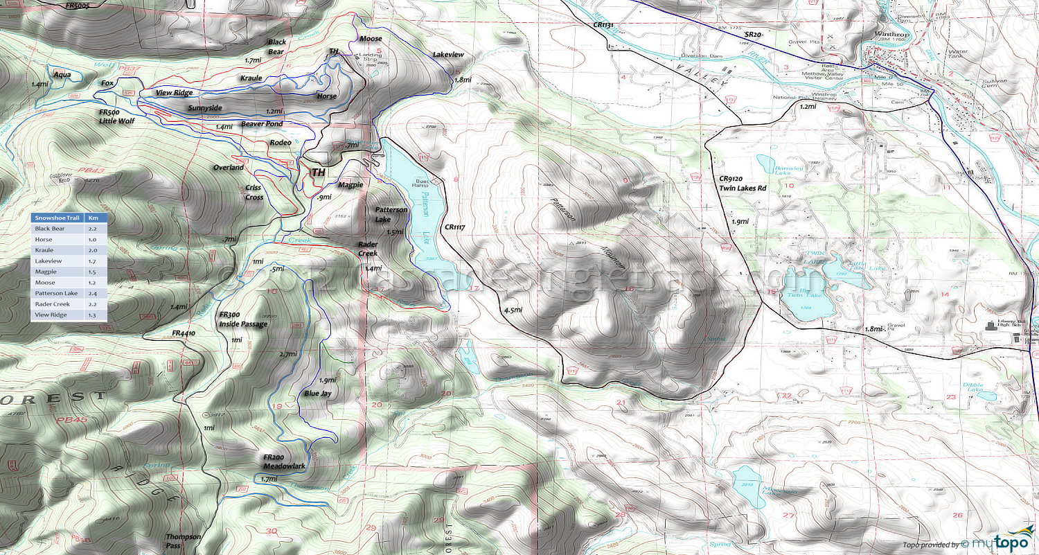
Sun Mountain Area XC Ski, Mountain Biking and Hiking Topo Map
Map includes: Aqua Loop Trail, Beaver Pond Trail, Black Bear Trail, Bluejay Trail, Cabin Trail, Chickadee Trail, Criss Cross Trail, Fox Trail, Horse Trail, Inside Passage Trail, Kraule Trail, Lakeview Trail, Magpie Trail, Meadowlark Trail, Moose Trail, Little Wolf Trail, Overland Trail, Patterson Lake Trail, Pine Forest Trail, Rader Creek Trail, Raven Trail, Rodeo Trail, Sunnyside Trail, View Ridge Trail, Wolf Creek Trail, Yellowjacket Trail Mountain Biking and Hiking Trails.
TH: From the Chickadee TH, ride .4mi, then go left onto FR320 (Inside Passage) and ascend towards Thompson Ridge alongside Rader Creek. Merge onto FR300 at 1.3mi and continue the ascent for 1mi.
2.3mi: Go left onto FR4410 at the ride summit and descend 1mi to FR200 (Meadowlark).
3.3mi: Go left onto FR200, then bear left at the 4mi FR220 (Goshawk) intersection and traverse the hillside to the 4.5mi Thompson Creek crossing. After a brief descent, go right onto Bluejay and continue traversing the hillside on the mostly doubletrack trail, passing a connector trail at 6.3mi.
6.9mi: Go right onto Meadowlark and descend the steep doubletrack to FR320, then go right.
8mi: Go right onto Rader Creek and continue the descent (through 2 gates) to Patterson Lake, then go left onto Patterson Lake (the trail. do not turn left into the lake.) at 9.5mi, near a doubletrack intersection.
11mi: After a gradual lakeside climb, go left onto the road and ride Cabin Trail to Magpie, then ride Magpie back to Rader Creek. Go right, then go right onto FR320 and cross FR4410. This completes the southern figure 8 loop.
12.3mi: Ride Criss Cross to FR500 (Little Wolf), crossing Overland at 12.7mi. Go right at FR500, then left onto Yellowjacket and ride alongside FR500 to the doubletrack (Fox) intersection, then go right.
14.2mi: Go right onto the doubletrack and ride past the Hough Homestead to Black Bear, which soon becomes singletrack. Descend the gradual Wolf Creek hillside traverse to the 16.2mi Moose intersection, then go onto Lakeview and continue the descent to the creek.
17.2mi: At the creek, go right onto the doubletrack and ascend alongside the creek to the 18mi CR1117 (Patterson Lake Rd) intersection. Go right and continue to the climb to the Chickadee TH.
Draggable map: Map window adjusts to screen size and will respond to touch control. Use scrollbar for mouse control.
No Map? Browser settings and some browser extensions can prevent the maps from appearing. Please see Site Tech


