
Tilly Jane Trail Area Mountain Biking and Hiking Topo Map
Twitter Search
#MountHoodWilderness
Map includes: Cooper Spur Trail 600B, Eden Park Trail 600H, Elk Cove Trail 631, Laurance Lake Loop Trail 632, Mazama Trail 625, McNeil Point Trail 600M, Pinnacle Ridge Trail 630, Polallie Falls Trail 29, Polallie Ridge Trail 643A, Tilly Jane Trail 643, Tilly Jane Trail 600A, Timberline Trail 600, Vista Ridge Trail 626 Mountain Biking and Hiking Trails.
Tilly Jane, Polallie Ridge CCW Loop
TH: Ascend Tilly Jane Tr643 from the Sno-Park TH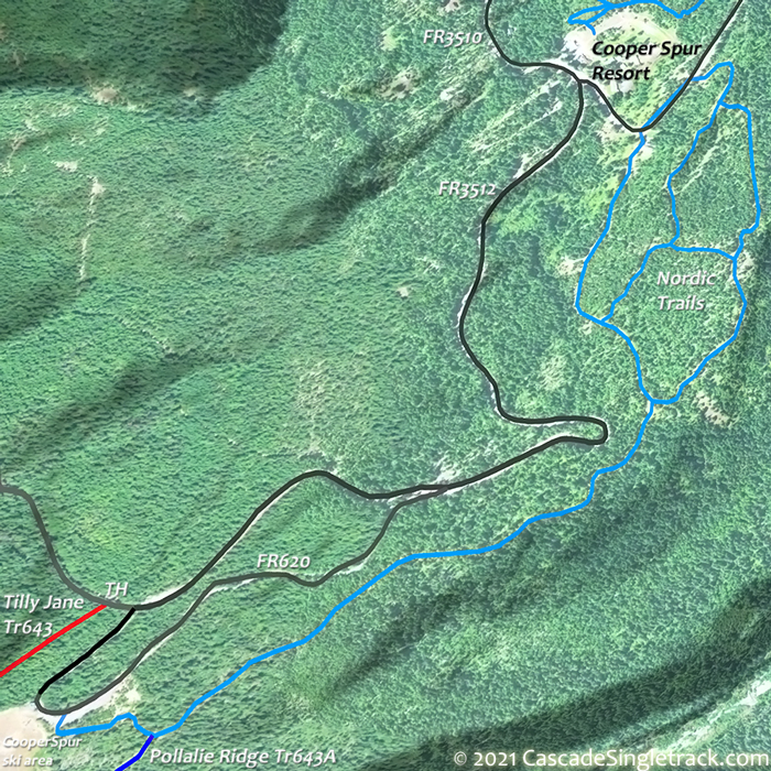
View of Cooper Spur Ski Area TH.
.6mi: Cross Doe Creek, followed by a steep .6mi ascent which may require some hike-a-bike.
1.9mi: Pass the upper Polallie Falls Tr29 intersection, then cross a tributary of Tilly Jane Creek.
2.3mi: Go left onto Polallie Ridge Tr643A, with an option to continue on Tilly Jane Tr643 to the Tilly Jane CG shelter, prior to descending Polallie Ridge Tr643A. From the campground, Tilly Jane Tr600A continues on to Timberline Tr600 wilderness area.
2.7mi: Pass the lower Polallie Falls Tr29 intersection. Continue descending the ridgeline to the ski area.
4.1mi: At the ski area, either go left to Tilly Jane Tr643 or ride the doubletrack switchback to the parking area.
Mount Hood Wilderness Hiking
Timberline Trail 600, Pacific Crest Trail 2000-G and surrounding trails form a hub and spoke trail system around Mount Hood in classic Pacific Northwest trails circumnavigating Mount Hood with alpine vistas, waterfalls, alpine meadows and west side Cascade forest.
This section of the Pacific Crest Trail extends from Barlow Pass to Lolo Pass, with Timberline Trail 600 surrounding the north and east sides of Mount Hood at the treeline, from Yocum Ridge to Timberline Lodge.
Timberline Trail 600 was constructed by the Civilian Conservation Corps in the 1930’s, with challenging glacial-fed drainages crossing Newton, Coe, Muddy Fork, Sandy and White Rivers.
Wilderness permits are required and locator beacons are suggested. Mount Hood Summit info. Don't become a statistic, be prepared, especially if climbing above Timberline Tr600. Consider using a guide if not experienced climbing Mt Hood.
The Area Maps on the following pages cover most of this trail system Pioneer Bridle Trail 795 East Fork Trail 650, Sahalie Falls Trail 667C, Timberline Glade Trail 661.
Timberline Tr600 TopSpur east to Cloud Cap crosses Lad, Coe and Eliot streams, with late season snow due to northern exposure and well established campsites at Mcneil Point, Carin basin (stone shelter) and Elk Cove.
Elk Cove Tr631 offers open views of the northern Mount Hood. The upper section wanders gently along the broadening ridge, crossing a shallow stream, then following a drainage switchback to the Timberline Tr600 intersection.
Pinnacle Ridge Tr630 follows Pinnacle Ridge to the scenic timberline area of Wy’east Basin and the Barrett Spur. After several stream crossings on the way to the treeline, cross a wet meadow area, after which the trail becomes faint, then is reestablished in the woods. Cross alpine meadows on the upper section of the trail, with close views of Mount Hood snowfields and spurs.
Vista Ridge Tr626 combines with Eden Park Loop Tr600H and Timberline Tr600, and offers relatively quick access to Elk Cove, Barrett Spur, Eden Park, Cairn Basin and Wy'east Basin.

Draggable map: Map window adjusts to screen size and will respond to touch control. Use scrollbar for mouse control.
No Map? Browser settings and some browser extensions can prevent the maps from appearing. Please see Site Tech

