
Boulder Lake Tr463
Twitter Search
#BoulderLakeTrail

Overall: 7
Aerobic: 6
Technical: 5
Steepness: 6
Flow: 6
Singletrack: 95%
The Mount Hood Oregon Gunsight Ridge Trail to Boulder Lake Tr463 offers an alternative to the well-known Gunsight to Gumjuwac CW Loop ride, with more moderate terrain and less road climbing.
The 2020 White River Fire damaged FR48 and the southern access to the Boulder Lake area. See the NF Site for closures.
As always, it is best to call the local Ranger District for trail conditions and other restrictions prior to riding, as the NF website may not contain trip-specific details.
Type
OAB
Length
Avg: 18mi
Ascent
Moderate
Elevation Change
TH:5900'
Avg Ascent:4200'
Ascent Incline
5%
Duration
Avg: 4hr
Weather
Forecast
NOAA
popup
USFS

Intermediate loop: The 18mi, (3800', 7%) Boulder Lake Tr463 to Gunsight Tr485 OAB. FR3550 can be used as an alternative to returning on Gunsight Tr485.

Hiking: As of August 2012, Crane Creek Tr478 was impassible at the Crane Prairie marsh and it is not currently listed as an open trail. It may be rerouted in the future so check with the forest service for current conditions if attempting that loop. Crane Prairie Tr464 is also not currently listed, so shown with dashed lines on the Area map. These trails along with Bonney Meadows Trail 471 are more easily accessible than most of the Badger Creek Wilderness terrain.
Directions: Boulder Lake TH: Take SR35S to FR48, then go 14.1mi to FR4880 and continue 6.4mi to the Boulder Lake TH. Note: FR4890/FR4891 to the Bonney Meadows CG 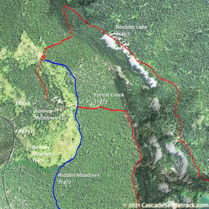
Bonney Meadows CG are rough and may not be passable by car. View Larger Map. No Map?.


OAB Directions
ridgeride
- A moderate 11mi, (3800', 7% ascent) loop ride starts at the FR4880 Boulder Lake TH, ascending Boulder Lake Tr463 to Forest Creek Tr473, returning on Hidden Meadows Tr472, with a CW loop providing an easier ascent.

Mount Hood Forest Hiking
Timberline Trail 600, Pacific Crest Trail 2000-G and surrounding trails form a hub and spoke trail system around Mount Hood in classic Pacific Northwest trails circumnavigating Mount Hood with alpine vistas, waterfalls, alpine meadows and west side Cascade forest.
The brief section of the Pacific Crest Trail 'F' shown on the Area Map extends from Barlow Pass to Clear Lake, and is the main connector trail for the Twin Lakes area.
The steep and rough Barlow Butte Trail 670 is the primary north-south connector, extending through meadows and along rocky viewpoints from Barlow Pass to the White River, near the Barlow Creek CG.
The steep Frog Lake Trail 530 returns through moss-lined forest to the Frog Lake CG from Twin Lakes Tr495. The very popular Lower Twin Lake is a short hike from the parking lot. The Upper Twin Lake offers more seclusion, with a cliff-edge viewpoint of Mount Hood and the Historic Barlow Creek Valley.
Twin Lakes Tr495 from Upper Twin Lake to PCT Tr2000-F is a narrow, rocky tread with some short steep grades.
From the Barlow Creek CG, Catalpa Lake Tr535 is a family-friendly trail, which provides easy access to a small, secluded and peaceful lake surrounded by firs and hemlocks and a rocky, rugged butte. Ascend through old growth forest, then cross Green Lake Creek and hike the gradual grade .7mi to Catalpa Lake. The trail continues around the lake to a primitive campground.
Trail Index
This Ride
Boulder Lake Trail 463, Forest Creek Trail 473, Hidden Meadows Trail 472
Area
Bottle Prairie Trail 455, Cedar Creek Trail 457, Cooks Meadow Trail 639, Dog River Trail 675, East Fork Trail 650, Eightmile Creek Trail 459, Fifteenmile Trail 456, Gumjuwac Trail 480, Gunsight Trail 485, Horkelia Meadows Trail 20, Knebal Springs Trail 474, Lookout Mountain Trail 450, Oak Ridge Trail 688A, Pocket Creek Trail 684, Polallie Ridge Trail 643A, Surveyors Ridge Trail 688, Tilly Jane Trail 643, Underhill Trail 683, Zig Zag Trail 678
Mount Hood Wilderness Hiking
Badger Creek Trail 479, Barlow Butte Trail 670, Blue Box Trail 483, Bonney Meadows Trail 471, Bluegrass Ridge Trail 647, Catalpa Lake Trail 535, Devils Half Acre Trail 482A, Elk Meadows Trail 645, Frog Lake Trail 530, Frog Lake Butte Trail 484, Little Boulder Trail 463A, Palmateer Trail 482, Polallie Falls Trail 29, Robinhood Trail 11, Tamanawas Falls Trail 650B, Tamanawas Tie Trail 650B, Twin Lakes Trail 495, White River Trail 538
XC Ski
Campgrounds
Badger Lake Campground, Barlow Creek Campground, Barlow Crossing Campground, Bonney Meadows Campground, Camp Windy, Clear Lake Campground, Devils Half Acre Meadow Campground, Forest Creek Campground, Frog Lake Campground, Grindstone Campground, Post Campground, White River Station Campground
Trail Rankings
Ranking consistently applied to all of the listed trails.
- Overall Rating: Ride quality and challenge
- Aerobic: Ascent challenge
- Technical Difficulty: Terrain challenge
- Steepness: Average incline
- Flow: Uninterrupted riding
- Elevation Change: Total elevation gain
- Ride Difficulty: Terrain challenge
