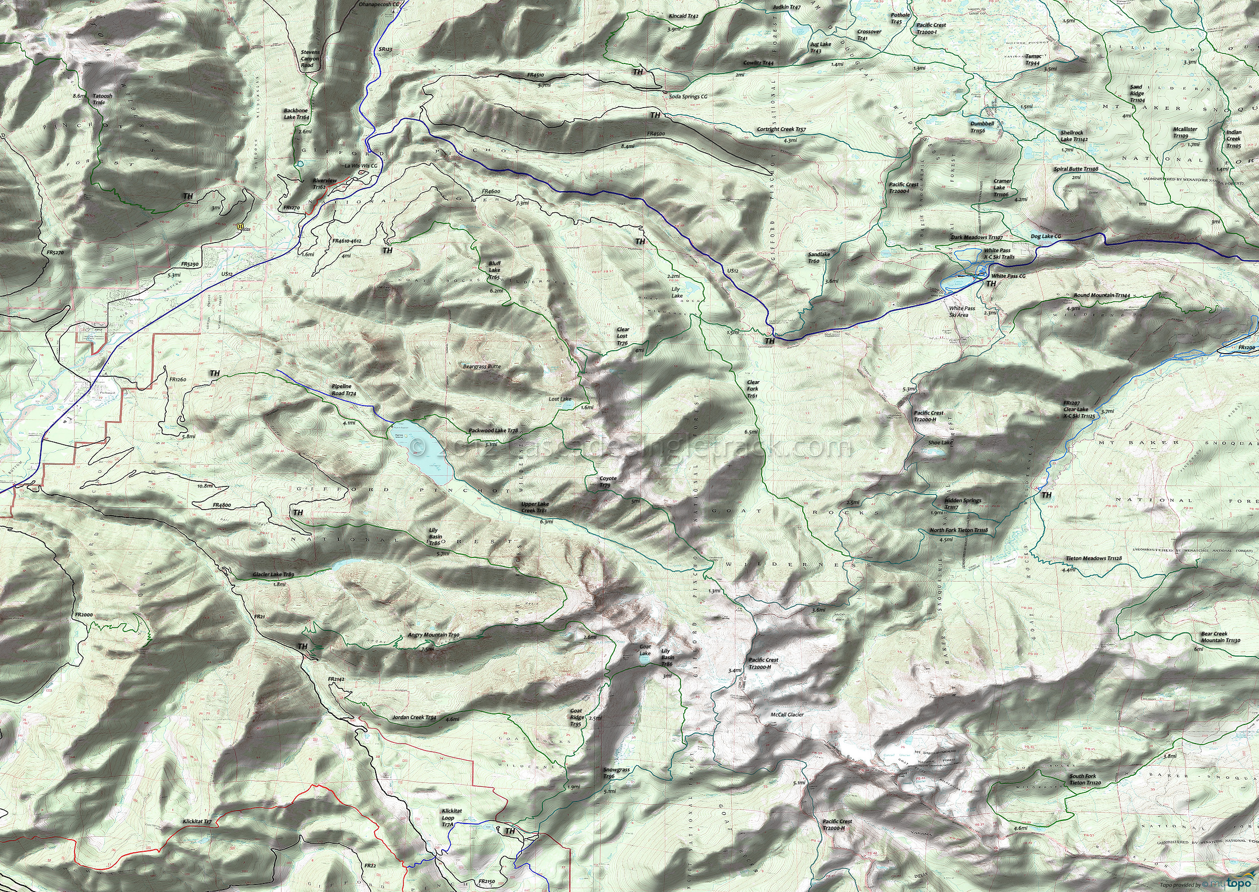
Goat Rocks Wilderness and Pacific Crest Trail Hiking Topo Map
Twitter Search
#PacificCrestTrail
Map includes: Angry Mountain Trail 90, Clear Fork Trail 61, Cowlitz Trail 44, Coyote Trail 79, Pacific Crest Trail 2000-H, Packwood Lake Trail 78 and Shellrock Lake Trail Hiking Trails.
Goat Rocks Hiking: Centered on the McCall Glacier and extending north to US12 and the William O Douglas wilderness, this easily accessible area offers many trailheads and campgrounds along FR21, US12 and Rimrock Lake.
Lily Basin Tr86 climbs a timbered, rugged ridgeline for 4mi to the west face of Johnson Peak, merging with the alpine Snowgrass Tr96 before reaching Pacific Crest Trail 2000-H at Snowgrass Flat (a 10 acre subalpine meadow in a bowl near the headwaters of Snowgrass Creek). Expect the upper sections of this hike to have snow cover until August. Snowgrass Tr96 switchbacks through talus and timber, part of the Klickitat Trail system used by Native Americans traveling over Cispus Pass to the Klickitat River drainage.
Clear Fork Tr61 passes Lily Lake then ascends the Clear Fork of the Cowlitz River, climbing steeply into a forested landscape to Pacific Crest Trail 2000-H at Tieton Pass. Likewise, Upper Lake Creek Tr81 ascends from Packwood lake to the Packwood Saddle, merging with Coyote Tr79. Packwood Lake Tr78 provides access to both of these trails, creating a good day hike loop option. The 452 acre Packwood Lake was used by the Taidnapam people as a fishing and camping site, formed when soil and rock slid off Snyder Mountain 1,200 years ago.
William O Douglas wilderness: North of US12 is a patchwork of easily accessible trails, which extend up to SR410. Tumac Mountain is the central feature, with many loop options from the east or south. Pacific Crest Tr2000-I starts at US12, near the Mount Rainier - Goat Rocks Observation Site, and is the connector trail for this area.
Kincaid Tr42 reaches the top of the ridge near Log Springs, crosses the summit burn, then follows the semiopen ridge. Offering excellent views of Rainier, the trail descends to Jug Lake Tr43 just east of Kincaid Lake. In the 1920s and 1930s the trail was used by sheepherders to reach their camps.
Cowlitz Tr44 winds through dense forest into subalpine terrain, crossing small streams and passing by lakes and small potholes, including Penoyer Lake. A main Native American route across the Cascades, Cowlitz Tr44 is part of the prehistoric Yakama Cowlitz Trail, which linked people from the Cowlitz Valley with people from the Yakima River drainage.
From Rimrock Lake FR1200, FR1207 provides access to Tieton Meadows Tr1128 and Bear Creek Mountain Tr1130. North Fork Tieton Tr1118 and Hidden Springs Tr1117 can be combined with Pacific Crest Trail 2000-H into a relatively short day hike.
Draggable map: Map window adjusts to screen size and will respond to touch control. Use scrollbar for mouse control.
No Map? Browser settings and some browser extensions can prevent the maps from appearing. Please see Site Tech


