Grouse Creek Vista: Pyramid Rock Tr180F
Twitter Search
#tarbelltrail

Overall: 6
Aerobic: 7
Technical: 6
Steepness: 7
Flow: 5
Singletrack: 100%
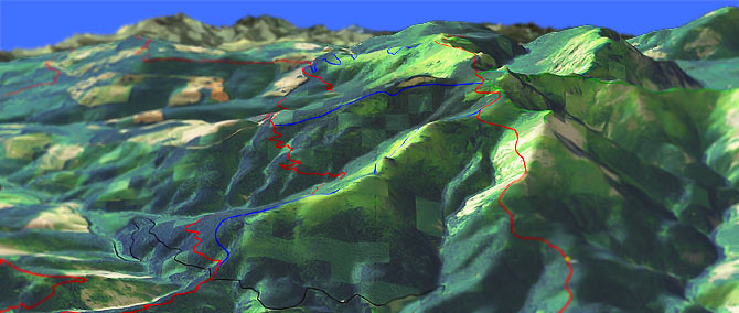
Grouse Creek Vista: The Vancouver Washington Pyramid Rock Trail ride is a variation of the Tarbell lollipop loop, commonly called Grouse Vista, because it starts from the Grouse Creek Vista trailhead.
Type
Loop
Length
Avg: 13mi
Ascent
Intense
Elevation Change
TH:2400'
Avg Ascent:4000'
Ascent Incline
14%
Duration
Avg: 3hr
Weather
Forecast
NOAA
popup
Silver Star Area Trails
At the edge of the Gifford Pinchot National Forest, this system of trails has three main trailheads, at Tarbell, Silver Star and Grouse Creek Vista.
Near Vancouver, the Silver Star area trails are popular with hikers, bikers and equestrians. As a result, the trails get a lot of use and receive good maintenance. There is enough terrain variety and trail length to create decent weekend destination rides, but not the kind of epic rides found further into the Gifford Pinchot National Forest.
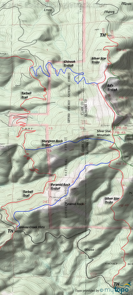
The typical 13mi CCW loop is a tour of Pyramid Rock, then Silver Star mountain to Kloochman Butte, passing Sturgeon Rock on way back.
Combining Pyramid Rock Tr180F, Silver Star Tr180, maybe an Indian Pit Tr180E OAB, Chinook Tr180B and Tarbell creates a tough CW or CCW loop, using either Pyramid Rock Tr180F or Chinook Tr180B for the Silver Star ascent.
The ride starts with the 2mi Pyramid Rock Tr180F, ascending 1460' (14% grade).
Many riders will not be able to clean the ascent, but it gets the big elevation gains out of the way at the start of the ride.
The only shuttle option would be to start at the northern Silver Star TH at FR4109, then ride to the Grouse Creek Vista TH, with about 16mi of driving using FR4109, L1100, L1210 and L1200 for just 5mi of downhill. Might be better to just grind through the Pyramid Rock Tr180F wall of pain.
Nearby Bells Mt is a good trail for those seeking easier terrain, but good shuttle opportunities on the other trails creates opportunities for advanced beginners.
Directions: From Battle Ground, go on Lucia Falls Park Rd to Moulton Falls, then to Sunset Falls Rd. Go right onto Sunset Falls and go 2.1mi to Dole Valley Rd. Go right onto Dole Valley and go 3.9mi, then the road turns into L1200. Continue 6.3mi to the Grouse Creek Vista TH. View Larger Map. No Map?.

Loop Directions
the wall
- TH: Steep .9mi Pyramid Rock ascent, with .4mi across the summit, then .8mi of steep climbing to Silver Star Tr180.
- 2.1mi: But wait, there's more.. Grind out another .5mi to finish the summit climb, then at 2.6mi, maybe go check out Indian Pit Tr180E.
- 3.7mi: Descend from Silver Star summit, then go left on Chinook Tr180B for a fast switchback ride to Tarbell Trail.
- 6.5mi: Go left at the Tarbell Trail and descend to the Coyote Creek Falls.
- 8.1mi: Cross the creek and begin 1000' switchback climb to Sturgeon Rock summit. Bail out point: In the first switchback, there is a jeep trail which leads to L1210.
- 10.2mi: At the Sturgeon Rock summit, pass the Sturgeon Rock Tr180C intersection, then descend 500' to Rock Creek Falls. Cross Rock Creek and continue on to the Grouse Creek Vista TH. Bail out point: At the Sturgeon Rock summit, there is a jeep trail which leads to L1210.
Trail Index
This Ride
Chinook Trail 180B, Pyramid Rock Trail 180F, Silver Star Trail 180, Tarbell Trail
Area
Campgrounds
Cold Creek Campground, Rock Creek Campground, Sunset Campground
Trail Rankings
Ranking consistently applied to all of the listed trails.
- Overall Rating: Ride quality and challenge
- Aerobic: Ascent challenge
- Technical Difficulty: Terrain challenge
- Steepness: Average incline
- Flow: Uninterrupted riding
- Elevation Change: Total elevation gain
- Ride Difficulty: Terrain challenge


