
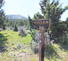
Gray Butte Trail 852
Twitter Search
#GreyButteTrail

Overall: 7
Aerobic: 6
Technical: 5
Steepness: 6
Flow: 6
Singletrack: 95%
The Redmond Oregon Gray Butte Tr852 is adjacent to Smith Rock State Park, with nearby Ridge Rider loops covering additional Crooked River National Grassland terrain.
Type
Loop
Length
Avg: 20mi
Ascent
Moderate
Elevation Change
TH:2700'
Avg Ascent:3300'
Ascent Incline
10%
Duration
Avg: 4hr
Weather
Forecast
NOAA
popup
USFS

Gray Butte Tr852 loop can be ridden in the winter when the ground has had time to dry out. The westside trail surface is a mix of clay and sand and sticks to everything when wet, to the point where riders have to carry their bikes because the tires won't roll. So avoid the Springtime thaw and after rainfall.
Gray Butte Tr852 ascends to the 23mi Cole Loop Tr854, with the 9mi Warner Tr854A as a spur loop.
Origins
Gray Butte basalt is about 18 million years old, with lava flows from the Newberry volcano flowing through the Crooked River canyon about 1.2 million years ago.
The volcanic center of Gray Butte is made of rhyolite tuff that was deposited as an ash flow about 12 million years ago.

Cole Loop Tr854 encircles Gray Butte and Warner is relatively flat. Consider using FR7290 (SW Park Ln) as the Cole Loop TH. This is a shared TH with some nearby ORV trails.

If the Ridge Rider trails are not open, the Gray Butte Tr852 can be ridden as a 12mi OAB or lolipop ride from the Burma Road intersection.
Summit and River Trail can be added to a Gray Butte ride, and are a great return to the state park TH.
Note: virtually all of the roads near the trails are merely doubletrack jeep trails. The three-digit 'roads' are little more than hiking trails.
The Crooked River is more of an irrigation waterway than anything else, and can become somewhat stagnant during the dry summer months, with short periods of seasonal whitewater rafting available as well.
Smith Rock State Park is a very popular rock climbing destination. Expect the most crowded trail conditions within the park area.
OR State Park Info. Although this page currently has links to the Deschutes NF, Gray Butte is part of the National Forest Grasslands area, at the edge of the Ochoco NF, so the page will be linked to that trail set once developed.
Directions: US97 to Terrebonne, then turn right on Smith Rock Rd and follow signs to the Park. View Larger Map. No Map?.


Loop Directions
shackle ride
- TH: From the parking area, descend the Canyon Trail to the bridge and go right, then ride Wolf Tree trail to the aqueduct and Burma Road.
- 1.7mi: Ascend the steep Burma Road (700' in 1mi) to the Summit/Gray Butte intersection.
- 2.7mi: Go right onto Gray Butte Tr852 and pass through a gate on the ascent to the doubletrack saddle crossing, then continue on to the FR5720 parking area.
- 5mi: At the parking area, cross the road to find the trail on the northeast side of the road (the return trail is on the west side of the road). Descend beside the stream to FR5710.
- 6.9mi: Cross the cattle guard and go left onto FR5710. Go left onto FR57 at the T intersection.
- 8.9mi: The Gray Butte Tr852 TH is on the left side of the road. Ascend to the ride summit at FR060, then descend through somewhat rocky terrain, some switchbacks and a gate, to FR5720.
- 12.6mi: With the loop complete, ride past the parking area and descend the hillside terrain, through the gate and back to the Summit Trail intersection.
- 15mi: Descend the steep, tight Summit Trail switchbacks, briefly passing a great Smith Rock State Park viewpoint, then continue the steep descent (passing through some private land) to the River Trail.
- 17mi: Pass the Monkey Face rock and ride alongside the Crooked River back to the TH. Expect many interactions with hikers, including small children and pets.


Henderson Flat OHV

Covered on both Area maps, the Henderson Flat OHV area has 18mi of trails over nearly 1500 acres in the Crooked River National Grassland and is open from April through November.
Trails are open to Class I (Quads, 3-wheelers less than 50" wide and 800 pounds) and Class III (motorcycles) ATVs.
See the Ochoco NF OHV page for more area info.
Trail Index
This Ride
Gray Butte Tr852, River Trail, Summit Trail, Wolf Tree Trail
Sisters Area Trails
Cross District Trail 4082, Green Ridge Trail 4025, Little Three Creek Lake Trail 4076, Maston Trails, Park Meadow Tie Trail 4102, Ridge Rider Trail 854 - Cole Loop, Ridge Rider Trail 854A - Warner Loop, Sisters Mountain Bike Trail 4090, Six Mile Butte Trail, Three Creek Meadow Trail 4103
Hiking
Canyon Trail, Homestead Trail, Horse Ford Trail, Mesa Verde Trail, Misery Ridge Trail, Rimrock Springs Trail, Rope De Dope Trail
Bend Area
Bens Trail 50, COD Trail 71, Edison-Lava Trail 31, Elfin Magic Trail 45, Farewell Trail 26, Flagline Trail 41, Flagline Access Trail 40.1, Flagline Tie Trail 41.1, Funner, Grand Slam Trail 44, Kents Trail 43, KGB Trail 72, Mrazek Trail 32, MTB Trail 51, North Fork Trail 24.2, Phils Trail 42, Sector 16 Trail 27, Skyliners Trail 28, South Fork Trail 25, Sparks Lake Trail 4, Storm King Trail 48, Swampy Lake Trail 23, Swampy Loop Trail 23.2, Swampy-Dutchman Trail 40, Swede Ridge Trail 52, Tiddlywinks, Tumalo Creek Trail 25.1, Tumalo Ridge Trail 25.2, Voodoo Trail 46
Campgrounds
Cyrus Horse Camp, Haystack Reservoir Campground, Skull Hollow Campground
Trail Rankings
Ranking consistently applied to all of the listed trails.
- Overall Rating: Ride quality and challenge
- Aerobic: Ascent challenge
- Technical Difficulty: Terrain challenge
- Steepness: Average incline
- Flow: Uninterrupted riding
- Elevation Change: Total elevation gain
- Ride Difficulty: Terrain challenge
